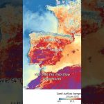
Satellites like Copernicus Sentinel-3 measure land surface temperature — that’s the heat coming directly from the ground, not the air above it. And yes, it’s often hotter in the summer than what your app tells you.
📹 European Space Agency (ESA) 📸 Contains modified Copernicus Sentinel data (2025), processed by ESA
ESA’s state-of-the-art Biomass mission is designed to provide new insights into the health and evolution of the world’s forests, helping us understand how they are changing over time and, importantly, their critical role in the global carbon cycle. Equipped with the first-ever fully polarimetric P-band synthetic aperture radar, this satellite can penetrate dense forest canopies. The long 70 cm wavelength of the radar enables it to measure ‘biomass’—the woody trunks, branches and stems—where trees store the majority of their carbon.
Credits: European Space Agency (ESA)
★ Subscribe: http://bit.ly/ESAsubscribe and click twice on the bell button to receive our notifications.
We are Europe’s gateway to space. Our mission is to shape the development of Europe’s space capability and ensure that investment in space continues to deliver benefits to the citizens of Europe and the world. Check out https://www.esa.int/ to get up to speed on everything space related.
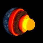
Geology is the study of the Earth itself. But contrary to popular belief, geologists don’t just look at rocks all day. Of course rocks are important to study, but geologists also study earthquakes, volcanoes, glaciers, and the structure of the Earth from the crust all the way to the core. What kinds of techniques do they use, and what have they discovered? Let’s find out together in this geology series!
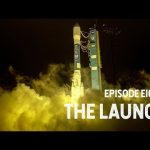
It’s 5 a.m. on a normal September day and #NASAExplorers have gathered in a California field to watch a rocket launch light up the pre-dawn sky. On board the rocket is a satellite more than 10 years in the making, with one single instrument that will revolutionize the study of ice on Earth. Join the team in the excitement and stress of watching ICESat-2 launch into space and begin its work measuring our home planet.
This week, #NASAExplorers head back in time…by going underground. In the Arctic, a frozen layer of soil – permafrost – trapped dead plants and animals for thousands of years. As the climate warms, that soil is beginning to thaw, releasing carbon dioxide and methane.
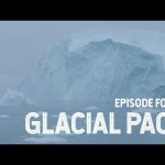
#NASAExplorers study Earth’s glaciers and ice sheets more than almost any other part of the cryosphere. As they melt and change, glaciers and ice sheets dramatically affect sea level rise and the climate system as a whole, creating an urgency to understand and forecast their behavior.
NASA Explorers is a new digital series that takes you inside the space agency and follows the pioneers, risk-takers and experts at the front line of exploration. Season 1, “Cryosphere,” joins NASA scientists on their journey to the frozen ends of the Earth as they study our rapidly changing world from satellites, planes and boots on the ground. The Cryosphere is a place we all depend on, but many of us will never go to. As temperatures rise, the frozen regions of Earth are changing rapidly. NASA scientists are locked in a race against time to understand our shifting climate and how it affects life on Earth.