Tag: fly

  • Fly across Nili Fossae with ESA’s Mars Express

    Fly across Nili Fossae with ESA’s Mars Express

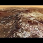
    Mars’s surface is covered in all manner of scratches and scars. Its many marks include the fingernail scratches of Tantalus Fossae, the colossal canyon system of Valles Marineris, the oddly orderly ridges of Angustus Labyrinthus, and the fascinating features captured in today’s video release from Mars Express: the cat scratches of Nili Fossae.

    Nili Fossae comprises parallel trenches hundreds of metres deep and several hundred kilometres long, stretching out along the eastern edge of a massive impact crater named Isidis Planitia.

    This new video features observations from Mars Express’s High Resolution Stereo Camera (HRSC). It first flies northwards towards and around these large trenches, showing their fractured, uneven appearance, before turning back to head southwards. It ends by zooming out to a ‘bird’s eye’ view, with the landing site of NASA’s Perseverance rover, Jezero Crater, visible in the lower-middle part of the final scene. (You can explore this crater further via ESA’s interactive map.)

    The trenches of Nili Fossae are actually features known as ‘graben’, which form when the ground sitting between two parallel faults fractures and falls away. As the graben seem to curve around Isidis Planitia, it’s likely that they formed as Mars’s crust settled following the formation of the crater by an incoming space rock hitting the surface. Similar ruptures – the counterpart to Nili Fossae – are found on the other side of the crater, and named Amenthes Fossae.

    Scientists have focused on Nili Fossae in recent years due to the impressive amount and diversity of minerals found in this area, including silicates, carbonates, and clays (many of which were discovered by Mars Express’s OMEGA instrument). These minerals form in the presence of water, indicating that this region was very wet in ancient martian history. Much of the ground here formed over 3.5 billion years ago, when surface water was abundant across Mars. Scientists believe that water flowed not only across the surface here but also beneath it, forming underground hydrothermal flows that were heated by ancient volcanoes.

    Because of what it could tell us about Mars’s ancient and water-rich past, Nili Fossae was considered as a possible landing site for NASA’s Curiosity rover, before the rover was ultimately sent to Gale Crater in 2012. Another mission, NASA’s Perseverance rover, was later sent to land in the nearby Jezero Crater, visible at the end of this video.

    Mars Express has visited Nili Fossae before, imaging the region’s graben system back in 2014. The mission has orbited the Red Planet since 2003, imaging Mars’s surface, mapping its minerals, studying its tenuous atmosphere, probing beneath its crust, and exploring how various phenomena interact in the martian environment. For more from the orbiter and its HRSC, see ESA’s Mars Express releases.

    Disclaimer: This video is not representative of how Mars Express flies over the surface of Mars. See processing notes below.

    Processing notes: The video is centred at 23°N, 78°E. It was created using Mars Chart (HMC30) data, an image mosaic made from single-orbit observations from Mars Express’s HRSC. This mosaic was combined with topography derived from a digital terrain model of Mars to generate a three-dimensional landscape. For every second of the movie, 62.5 separate frames are rendered following a pre-defined camera path. The vertical exaggeration is three-fold. Atmospheric effects – clouds and haze – have been added, and start building up at a distance of 50 km.

    Credit: ESA/DLR/FU Berlin & NASA/JPL-Caltech/MSSS, CC BY-SA 3.0 IGO

    ★ Subscribe: http://bit.ly/ESAsubscribe and click twice on the bell button to receive our notifications.

    Check out our full video catalog: http://bit.ly/SpaceInVideos
    Follow us on Twitter: http://bit.ly/ESAonTwitter
    On Facebook: http://bit.ly/ESAonFacebook
    On Instagram: http://bit.ly/ESAonInstagram
    On LinkedIn: https://bit.ly/ESAonLinkedIn
    On Pinterest: https://bit.ly/ESAonPinterest
    On Flickr: http://bit.ly/ESAonFlickr

    We are Europe’s gateway to space. Our mission is to shape the development of Europe’s space capability and ensure that investment in space continues to deliver benefits to the citizens of Europe and the world. Check out https://www.esa.int/ to get up to speed on everything space related.

    Copyright information about our videos is available here: https://www.esa.int/ESA_Multimedia/Terms_and_Conditions

    #ESA #Mars #Satellite

  • Fly across Mars’s ‘labyrinth of night’ with Mars Express

    Fly across Mars’s ‘labyrinth of night’ with Mars Express

    Nestled between the colossal martian ‘Grand Canyon’ (Valles Marineris) and the tallest volcanoes in the Solar System (the Tharsis region) lies Noctis Labyrinthus – a vast system of deep and steep valleys that stretches out for around 1190 km (roughly the length of Italy here on Earth).

    This video visualises a flight over the eastern part of Noctis Labyrinthus as seen by Mars Express’s High Resolution Stereo Camera (HRSC). It presents a perspective view down and across this fascinating landscape, showing distinctive ‘graben’ – parts of the crust that have subsided in relation to their surroundings. The intense volcanism in the nearby Tharsis region is to blame for the formation of these features; this volcanism caused large areas of martian crust to arch upwards and become stretched and tectonically stressed, leading to it thinning out, faulting and subsiding.

    The highest plateaus seen here represent the original surface level before chunks of surface fell away. The intersecting canyons and valleys are up to 30 km wide and six km deep. In many places, gigantic landslides can be seen covering the valley slopes and floors, while other valley slopes show large dune fields created by sands blown both down and upslope by martian winds.

    ESA has highlighted Mars Express images of Noctis Labyrinthus before, in 2006 and 2015. Mars Express has orbited the Red Planet since 2003, imaging Mars’s surface, mapping its minerals, studying its tenuous atmosphere, probing beneath its crust, and exploring how various phenomena interact in the martian environment. For more from the mission and HRSC, see ESA’s Mars Express releases.

    Processing notes: The video was created using an image mosaic built over eight orbits (0442, 1085, 1944, 1977, 1988, 10497, 14632 and 16684) by ESA’s Mars Express and its HRSC. This mosaic is combined with topographic information from a digital terrain model to generate a three-dimensional landscape, with every second of the video comprising 50 separate frames rendered according to a pre-defined camera path. The opening credits (Mars globe, first 24 seconds) were created using the recent 20-year Mars global colour mosaic; this opening sequence has a three-fold vertical exaggeration, while the subsequent flight animation has a 1.5-fold exaggeration. Haze has been added to conceal the limits of the terrain model, and starts building up at distance of between 150 and 200 km. The video is centred at the martian coordinates of 7°S, 265°E.

    Alt-text: The video begins on a rotating full-globe of Mars, with white polar caps and mottled tan surface visible. It then zooms in on the westernmost part of the large Valles Marineris canyon system, a region highlighted by a white box, and swaps to a new Mars Express visualisation of Noctis Labyrinthus. The camera then flies slowly across a landscape that is broken apart by deep intersecting valleys and canyons.

    Credit: ESA/DLR/FU Berlin & NASA/JPL-Caltech/MSSS, CC BY-SA 3.0 IGO

    ★ Subscribe: http://bit.ly/ESAsubscribe and click twice on the bell button to receive our notifications.

    Check out our full video catalog: http://bit.ly/SpaceInVideos
    Follow us on Twitter: http://bit.ly/ESAonTwitter
    On Facebook: http://bit.ly/ESAonFacebook
    On Instagram: http://bit.ly/ESAonInstagram
    On LinkedIn: https://bit.ly/ESAonLinkedIn
    On Pinterest: https://bit.ly/ESAonPinterest
    On Flickr: http://bit.ly/ESAonFlickr

    We are Europe’s gateway to space. Our mission is to shape the development of Europe’s space capability and ensure that investment in space continues to deliver benefits to the citizens of Europe and the world. Check out https://www.esa.int/ to get up to speed on everything space related.

    Copyright information about our videos is available here: https://www.esa.int/ESA_Multimedia/Terms_and_Conditions

    #ESA
    #Mars
    #MarsExpress

  • Fly a Rocket! programme

    Fly a Rocket! programme

    The Fly a Rocket! programme offers the chance to University students early in their studies to learn about rocketry and to launch their very own rocket from Andøya Space Center. This programme is realised in partnership with the Norwegian Center for Space-related Training (NAROM) and the Norwegian Space Center (Norsk Romsenter).

    More info: https://www.esa.int/Education/Fly_A_Rocket/About_Fly_a_Rocket

    ★ Subscribe: http://bit.ly/ESAsubscribe and click twice on the bell button to receive our notifications.

    Check out our full video catalog: http://bit.ly/SpaceInVideos
    Follow us on Twitter: http://bit.ly/ESAonTwitter
    On Facebook: http://bit.ly/ESAonFacebook
    On Instagram: http://bit.ly/ESAonInstagram
    On Flickr: http://bit.ly/ESAonFlickr

    We are Europe’s gateway to space. Our mission is to shape the development of Europe’s space capability and ensure that investment in space continues to deliver benefits to the citizens of Europe and the world. Check out http://www.esa.int/ESA to get up to speed on everything space related.

    Copyright information about our videos is available here: http://www.esa.int/spaceinvideos/Terms_and_Conditions

    #ESA
    #FlyaRocket
    #Rocketry

  • Fly Your Satellite!

    Fly Your Satellite!

    Fly Your Satellite! is an educational programme for university students, created by ESA after the launch of seven university CubeSats on the 2012 Vega maiden flight. Six teams participated in the first edition of the programme, which concluded in 2016 with the launch of three satellites, while in parallel a pilot edition was undertaken to deploy a satellite from the International Space Station. The second edition of Fly Your Satellite! is currently ongoing since 2017, and participating university teams are advancing closer towards testing and launch. The call for proposals for the third edition is now open.

    Apply: http://bit.ly/FlyYourSatellite3Call

    Credits: ESA

    ★ Subscribe: http://bit.ly/ESAsubscribe and click twice on the bell button to receive our notifications.

    Check out our full video catalog: http://bit.ly/SpaceInVideos
    Follow us on Twitter: http://bit.ly/ESAonTwitter
    On Facebook: http://bit.ly/ESAonFacebook
    On Instagram: http://bit.ly/ESAonInstagram
    On Flickr: http://bit.ly/ESAonFlickr

    We are Europe’s gateway to space. Our mission is to shape the development of Europe’s space capability and ensure that investment in space continues to deliver benefits to the citizens of Europe and the world. Check out http://www.esa.int/ESA to get up to speed on everything space related.

    Copyright information about our videos is available here: http://www.esa.int/spaceinvideos/Terms_and_Conditions

    #ESA
    #Education
    #FlyYourSatellite

  • NASA Prepares to Fly a Large Unmanned Aircraft in Public Airspace Without Chase Plane for First Time

    NASA Prepares to Fly a Large Unmanned Aircraft in Public Airspace Without Chase Plane for First Time

    NASA’s remotely-piloted Ikhana aircraft performs flight tests in preparation to fly in the National Airspace System without a safety chase aircraft. On June 12, 2018, NASA successfully flew the historic flight. News release: https://www.nasa.gov/press-release/nasa-flies-large-unmanned-aircraft-in-public-airspace-without-chase-plane-for-first

    The flight will help to move the United States one step closer to normalizing unmanned aircraft operations in the airspace used by commercial and private pilots. The Ikhana aircraft is based at NASA’s Armstrong Flight Research Center in Edwards, California.

  • Fly over Neukum crater

    Fly over Neukum crater

    This movie, based on images taken by ESA’s Mars Express, showcases the 102 km wide Neukum Crater in the southern hemisphere of Mars.

    The crater is named for the German physicist and planetary scientist, Gerhard Neukum, one of the founders of ESA’s Mars Express mission who inspired and led the development of the high-resolution stereo camera on Mars Express.

    This complex impact crater has a diverse geologic history, as indicated by various features on the crater rim and floor. Particularly striking are the dark dune fields, likely made up of volcanic material blown in and shaped by strong winds.

    The crater’s shallow interior has been infilled by sediments over its history. It is also marked with two irregular depressions that may be a sign of a weaker material that has since eroded away, leaving behind some islands of more resistant material.

    Over time the crater rim has undergone varying degrees of collapse, with landslides and slumped material visible in the crater walls. Many smaller craters have also overprinted the rim and pockmarked the interior since Neukum Crater was formed, highlighting its long history.

    Neukum Crater is situated in Noachis Terra, one of the oldest known regions on Mars, dating back to at least 3.9 billion years.

    Credits: Animation: ESA/DLR/FU Berlin, CC BY-SA 3.0 IGO; Music: Coldnoise, CC BY-SA 4.0 and Adrian Neesemann

    ★ Subscribe: http://bit.ly/ESAsubscribe

    Learn more: http://bit.ly/ESACraterNeukum

  • Fly into the Great Red Spot of Jupiter with NASA’s Juno Mission

    Fly into the Great Red Spot of Jupiter with NASA’s Juno Mission

    This animation takes the viewer on a simulated flight into, and then out of, Jupiter’s upper atmosphere at the location of the Great Red Spot. It was created by combining an image from the JunoCam imager on NASA’s Juno spacecraft with a computer-generated animation.

    The perspective begins about 2,000 miles (3,000 kilometers) above the cloud tops of the planet’s southern hemisphere. The bar at far left indicates altitude during the quick descent; a second gauge next to that depicts the dramatic increase in temperature that occurs as the perspective dives deeper down. The clouds turn crimson as the perspective passes through the Great Red Spot. Finally, the view ascends out of the spot.

    For more, visit https://www.nasa.gov/feature/jpl/nasas-juno-probes-the-depths-of-jupiters-great-red-spot

  • Tonight Showbotics: Jimmy Meets Sophia the Human-Like Robot

    Tonight Showbotics: Jimmy Meets Sophia the Human-Like Robot

    Jimmy Fallon demos amazing new robots from all over the world, including an eerily human robot named Sophia that plays rock-paper-scissors.

    Subscribe NOW to The Tonight Show Starring Jimmy Fallon: http://bit.ly/1nwT1aN

    Watch The Tonight Show Starring Jimmy Fallon Weeknights 11:35/10:35c
    Get more Jimmy Fallon:
    Follow Jimmy: http://Twitter.com/JimmyFallon
    Like Jimmy: https://Facebook.com/JimmyFallon

    Get more The Tonight Show Starring Jimmy Fallon:
    Follow The Tonight Show: http://Twitter.com/FallonTonight
    Like The Tonight Show: https://Facebook.com/FallonTonight
    The Tonight Show Tumblr: http://fallontonight.tumblr.com/

    Get more NBC:
    NBC YouTube: http://bit.ly/1dM1qBH
    Like NBC: http://Facebook.com/NBC
    Follow NBC: http://Twitter.com/NBC
    NBC Tumblr: http://nbctv.tumblr.com/

    The Tonight Show Starring Jimmy Fallon features hilarious highlights from the show including: comedy sketches, music parodies, celebrity interviews, ridiculous games, and, of course, Jimmy’s Thank You Notes and hashtags! You’ll also find behind the scenes videos and other great web exclusives.

    Tonight Showbotics: Snakebot, Sophia, eMotion Butterflies
    http://www.youtube.com/fallontonight
    #FallonTonight #SophiaRobot #HansonRobotics

  • Fly over Mawrth Vallis

    Fly over Mawrth Vallis

    This movie, based on images taken by ESA’s Mars Express, highlights Mawrth Vallis, a 600 km-long, 2 km-deep outflow channel at the boundary of the southern highlands and the northern lowlands of Mars.

    The movie begins at the mouth of the channel in Chryse Planitia, and heads towards the apparent source region in the Arabia Terra highlands.

    The 4 billion year-old plateau is characterised by many impact craters, indicative of its great age.

    Zooming in, patches of light and dark deposits are revealed. The light-toned layered sediments are among the largest outcrops of clay minerals – phyllosilicates – on Mars. Their presence indicates the presence of liquid water in the past.

    The variety of water-bearing minerals and the possibility that they might contain a record of an ancient, habitable environment on Mars led scientists to propose Mawrth Vallis as a candidate landing site for the ExoMars 2020 mission.

    The animation is based on a colour mosaic and digital terrain model derived from data collected by the high-resolution stereo camera on Mars Express and released earlier this year.

    More info:
    http://exploration.esa.int/mars/54721-mawrth-vallis/
    http://www.esa.int/spaceinimages/Images/2016/09/Mawrth_Vallis_martian_mosaic

    Credits: ESA/DLR/FU Berlin, CC BY-SA 3.0 IGO

  • Fun Fly Stick

    Fun Fly Stick

    Steve Spangler demonstrating The Fun Fly Stick. An ingenious battery operated static electricity generator that allows you to float tinsel shapes on a cloud of electrons.

  • “Fly Me To The Moon” at NASA’s 50th gala

    “Fly Me To The Moon” at NASA’s 50th gala

    A special live performance directed by Quincy Jones and performed by Frank Sinatra, Jr., at the AIAA 50th anniversary celebration for NASA. Learn more at www.nasa.gov.

  • Fun Fly Stick – Cool Science Toy

    Fun Fly Stick – Cool Science Toy

    To purchase your own Fun Fly Stick, visit http://www.stevespanglerscience.com/product/fun-fly-stick Ever want to make something magically float? Well now you can! Steve Spangler discusses the science behind a cool science toy called the Fun Fly Stick.

    About Steve Spangler Science…

    Steve Spangler is a celebrity teacher, science toy designer, speaker, author and an Emmy award-winning television personality. Spangler is probably best known for his Mentos and Diet Coke geyser experiment that went viral in 2005 and prompted more than 1,000 related YouTube videos. Spangler is the founder of www.SteveSpanglerScience.com, a Denver-based company specializing in the creation of science toys, classroom science demonstrations, teacher resources and home for Spangler’s popular science experiment archive and video collection. Spangler is a frequent guest on the Ellen DeGeneres Show where he takes classroom science experiments to the extreme. Check out his pool filled with 2,500 boxes of cornstarch!

    Cool Science Toys – http://www.SteveSpanglerScience.com
    Sign up for the Experiment of the Week – http://www.stevespanglerscience.com/experiment-of-the-week
    Watch Spangler’s Science Videos – http://www.stevespanglerscience.com/video/
    Attend a Spangler Hands-on Science Workshop for Teachers – http://www.stevespanglerscience.com/teacher_training/
    Visit Spangler’s YouTube Channel – http://www.youtube.com/stevespanglerscience

    Join the conversation on Steve Spangler’s blog – http://www.SteveSpangler.com

    Additional Information:

    On the education side, Spangler started his career as a science teacher in the Cherry Creek School district for 12 years. Today, Steve travels extensively training teachers in ways to make learning more engaging and fun. His hands-on science boot camps and summer institutes for teachers inspire and teach teachers how to prepare a new generation for an ever-changing work force. Over the last 15 years, he has also made more than 500 television appearances as an authority on hands-on science and inquiry-based learning.

    On the business side, Spangler is the founder and CEO of Steve Spangler Science, a Denver-based company specializing in the creation of educational toys and kits and hands-on science training services for teachers. The companys unique business strategies and viral creations have been featured in the Wall Street Journal, Inc. Magazine, Wired and TIME Magazine where online readers voted Steve Spangler #18 in the Top 100 Most Influential People of the Year for 2006 (what were they thinking?). You’ll find more than 140 Spangler created products available online at SteveSpanglerScience.com and distributed to toy stores and mass-market retailers worldwide.

    Spangler joined NBC affiliate 9News in 2001 as the science education specialist. His weekly experiments and science segments are designed to teach viewers creative ways to make learning fun. His now famous Mentos Geyser experiment, turning 2-liter bottles of soda into erupting fountains, became an Internet sensation in September 2005 when thousands of people started posting their own Mentos explosions on YouTube.com.

    As founder of SteveSpanglerScience.com, Spangler and his design team have developed more than 140 educational toys and science-related products featured by mass-market retailers like Target, Wal-Mart, Toys R’ Us, Discovery Channel Stores and over 1,400 independent specialty toy stores. His educational science catalog and on-line business offers more than a thousand science toys and unique learning resources. Recently, Spangler has been featured in the Wall Street Journal, Inc. Magazine, WIRED, the History Channel, Food Network and TIME Magazine where on-line readers voted Steve Spangler #18 in the Top 100 Most Influential People of the Year for 2006.

    His recent appearances on the Ellen DeGeneres Show have taught viewers how to blow up their food, shock their friends, create mountains of foam, play on a bed of nails, vanish in a cloud of smoke and how to turn 2,500 boxes of cornstarch and a garden hose into a swimming pool of fun.