This time-lapse video taken by NASA astronaut Nick Hague squeezes a 30-minute International Space Station trip over a cloudy Earth into 60 seconds, covering the Pacific to the Atlantic.
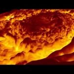
In this animation the viewer is taken low over Jupiter’s north pole to illustrate the 3-D aspects of the region’s central cyclone and the eight cyclones that encircle it.
Read more: https://www.nasa.gov/feature/jpl/nasa-s-juno-mission-provides-infrared-tour-of-jupiter-s-north-pole
The movie utilizes imagery derived from data collected by the Jovian Infrared Auroral Mapper (JIRAM) instrument aboard NASA’s Juno mission during its fourth pass over the massive planet. Infrared cameras are used to sense the temperature of Jupiter’s atmosphere and provide insight into how the powerful cyclones at Jupiter’s poles work. In the animation, the yellow areas are warmer (or deeper into Jupiter’s atmosphere) and the dark areas are colder (or higher up in Jupiter’s atmosphere). In this picture the highest “brightness temperature” is around 260K (about -13°C) and the lowest around 190K (about -83°C). The “brightness temperature” is a measurement of the radiance, at 5 µm, traveling upward from the top of the atmosphere towards Juno, expressed in units of temperature.
Credit: NASA/JPL-Caltech/SwRI/ASI/INAF/JIRAM
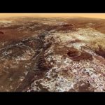
This movie, based on images taken by ESA’s Mars Express, highlights Mawrth Vallis, a 600 km-long, 2 km-deep outflow channel at the boundary of the southern highlands and the northern lowlands of Mars.
The movie begins at the mouth of the channel in Chryse Planitia, and heads towards the apparent source region in the Arabia Terra highlands.
The 4 billion year-old plateau is characterised by many impact craters, indicative of its great age.
Zooming in, patches of light and dark deposits are revealed. The light-toned layered sediments are among the largest outcrops of clay minerals – phyllosilicates – on Mars. Their presence indicates the presence of liquid water in the past.
The variety of water-bearing minerals and the possibility that they might contain a record of an ancient, habitable environment on Mars led scientists to propose Mawrth Vallis as a candidate landing site for the ExoMars 2020 mission.
The animation is based on a colour mosaic and digital terrain model derived from data collected by the high-resolution stereo camera on Mars Express and released earlier this year.
NASA’s 747 Shuttle Carrier Aircraft, carrying space shuttle Endeavour, as it flew over NASA’s Ames Research Center in Mountain Valley, Calif. on Sept. 21.