Tag: pollution

  • Keeping an eye on ocean plastic pollution…from space!

    Keeping an eye on ocean plastic pollution…from space!

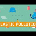
    Meet bag, bottle and straw, three bits of plastic left on the beach.
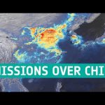
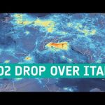
    They are only small, but they are heading into the ocean, where they could cause big damage. ESA is exploring how satellites can help detect and reduce plastic pollution in the ocean. From spotting build-ups of marine litter to tracking ocean currents, satellites could be game-changing in tackling this enormous environmental problem.

    Though engaging for children and adults alike, this video is designed with primary
    school students in mind. In particular, teachers can use it to introduce the topic of marine litter in subjects such as geography and science.

    Dutch version available here: https://youtu.be/ScSCXaSnjhE

    Credits: ESA – Science Office
    Project coordination: Nicole Shearer (EJR-Quartz for ESA) and Mariana Barrosa (Science Office) Scientific advice: Peter de Maagt and Paolo Corradi (both ESA), Joana
    Mira Veiga (Deltares)
    Educational advice: Petra de Clippelaar (BSO ‘t Vogelnest) and Connor Mackelvey (Iroquois Elementary School)
    Design and animation: David Santos and Rui Braz (both Science Office)

    ★ Subscribe: http://bit.ly/ESAsubscribe and click twice on the bell button to receive our notifications.

    Check out our full video catalog: http://bit.ly/SpaceInVideos
    Follow us on Twitter: http://bit.ly/ESAonTwitter
    On Facebook: http://bit.ly/ESAonFacebook
    On Instagram: http://bit.ly/ESAonInstagram
    On Pinterest: https://bit.ly/ESAonPinterest
    On Flickr: http://bit.ly/ESAonFlickr

    We are Europe’s gateway to space. Our mission is to shape the development of Europe’s space capability and ensure that investment in space continues to deliver benefits to the citizens of Europe and the world. Check out https://www.esa.int/ to get up to speed on everything space related.

    Copyright information about our videos is available here: https://www.esa.int/ESA_Multimedia/Terms_and_Conditions

    #ESAKids
    #PlasticPollution
    #EarthObservation

  • The Journey of Resilience to The Space Station on This Week @NASA – November 21, 2020

    The Journey of Resilience to The Space Station on This Week @NASA – November 21, 2020

    The journey of Resilience to the space station, the next ocean-observing satellite, and an update on a critical rocket test series for our Artemis missions … a few of the stories to tell you about – This Week at NASA!

    Download link: images-assets.nasa.gov/video/The Journey of Resilience to The Space Station on This Week @NASA – November 21 2020/The Journey of Resilience to The Space Station on This Week @NASA – November 21 2020~orig.mp4

    Producer: Andre Valentine
    Editor: Sonnet Apple
    Music: Universal Production Music

  • Monitoring air quality

    Monitoring air quality

    Featuring how the Sentinel-5P mission of the European Union’s Copernicus Programme has become a game-changer for monitoring our atmosphere while being one of the most important sources of data for the Copernicus Atmosphere Monitoring Service.

    ★ Subscribe: http://bit.ly/ESAsubscribe and click twice on the bell button to receive our notifications.

    Check out our full video catalog: http://bit.ly/SpaceInVideos
    Follow us on Twitter: http://bit.ly/ESAonTwitter
    On Facebook: http://bit.ly/ESAonFacebook
    On Instagram: http://bit.ly/ESAonInstagram
    On Flickr: http://bit.ly/ESAonFlickr

    We are Europe’s gateway to space. Our mission is to shape the development of Europe’s space capability and ensure that investment in space continues to deliver benefits to the citizens of Europe and the world. Check out http://www.esa.int/ESA to get up to speed on everything space related.

    Copyright information about our videos is available here: http://www.esa.int/spaceinvideos/Terms_and_Conditions

    #ESA
    #EarthObservation
    #AirQuality

  • Nitrogen dioxide emissions over China

    Nitrogen dioxide emissions over China

    This animation, using data from the Copernicus Sentinel-5P satellite, shows the nitrogen dioxide emissions from 20 December 2019 until 16 March 2020 – using a 10-day moving average. The drop in emissions in late-January is visible, coinciding with the nationwide quarantine, and from the beginning of March, the nitrogen dioxide levels have begun to increase.

    Learn more: http://bit.ly/COVID19NitrogenDioxideOverChina

    Credits: contains modified Copernicus Sentinel data (2019-20), processed by ESA, CC BY-SA 3.0 IGO

    ★ Subscribe: http://bit.ly/ESAsubscribe and click twice on the bell button to receive our notifications.

    Check out our full video catalog: http://bit.ly/SpaceInVideos
    Follow us on Twitter: http://bit.ly/ESAonTwitter
    On Facebook: http://bit.ly/ESAonFacebook
    On Instagram: http://bit.ly/ESAonInstagram
    On Flickr: http://bit.ly/ESAonFlickr

    We are Europe’s gateway to space. Our mission is to shape the development of Europe’s space capability and ensure that investment in space continues to deliver benefits to the citizens of Europe and the world. Check out http://www.esa.int/ESA to get up to speed on everything space related.

    Copyright information about our videos is available here: http://www.esa.int/spaceinvideos/Terms_and_Conditions

    #ESA
    #

  • Coronavirus: nitrogen dioxide emissions drop over Italy

    Coronavirus: nitrogen dioxide emissions drop over Italy

    New data from the Copernicus Sentinel-5P satellite reveal the decline of air pollution, specifically nitrogen dioxide emissions, over Italy. This reduction is particularly visible in northern Italy which coincides with its nationwide lockdown to prevent the spread of the coronavirus.

    The animation shows the fluctuation of nitrogen dioxide emissions across Europe from 1 January 2020 until 11 March 2020, using a 10-day moving average. These data are thanks to the Tropomi instrument on board the Copernicus Sentinel-5P satellite which maps a multitude of air pollutants around the globe.

    Claus Zehner, ESA’s Copernicus Sentinel-5P mission manager, comments, “The decline in nitrogen dioxide emissions over the Po Valley in northern Italy is particularly evident.

    “Although there could be slight variations in the data due to cloud cover and changing weather, we are very confident that the reduction in emissions that we can see, coincides with the lockdown in Italy causing less traffic and industrial activities.”

    Josef Aschbacher, ESA’s Director of Earth Observation Programmes, says, “Copernicus Sentinel-5P Tropomi is the most accurate instrument today that measures air pollution from space. These measurements, globally available thanks to the free and open data policy, provide crucial information for citizens and decision makers.”

    The coronavirus disease (COVID-19) was recently declared a pandemic by the World Health Organisation, with more than 125 000 current cases of the disease reported globally. In Italy, the number of coronavirus cases drastically soared making it the country with the largest number of cases outside of China.

    In an attempt to reduce the spread of the disease, Italy’s Prime Minister Giuseppe Conte announced a lockdown of the entire country – closing schools, restaurants, bars, museums and other venues across the country.

    The Sentinel-5 Precursor – also known as Sentinel-5P – is the first Copernicus mission dedicated to monitoring our atmosphere. The satellite carries the Tropomi instrument to map a multitude of trace gases such as nitrogen dioxide, ozone, formaldehyde, sulphur dioxide, methane, carbon monoxide and aerosols – all of which affect the air we breathe and therefore our health, and our climate.

    Given the growing importance and need for the continuous monitoring of air quality, the upcoming Copernicus Sentinel-4 and Sentinel-5 missions, as part of the EU’s Copernicus programme, will monitor key air quality trace gases and aerosols. These missions will provide information on air quality, stratospheric ozone and solar radiation, as well as climate monitoring.

    Credits: contains modified Copernicus Sentinel data (2020), processed by ESA, CC BY-SA 3.0 IGO

    ★ Subscribe: http://bit.ly/ESAsubscribe and click twice on the bell button to receive our notifications.

    Check out our full video catalog: http://bit.ly/SpaceInVideos
    Follow us on Twitter: http://bit.ly/ESAonTwitter
    On Facebook: http://bit.ly/ESAonFacebook
    On Instagram: http://bit.ly/ESAonInstagram
    On Flickr: http://bit.ly/ESAonFlickr

    We are Europe’s gateway to space. Our mission is to shape the development of Europe’s space capability and ensure that investment in space continues to deliver benefits to the citizens of Europe and the world. Check out http://www.esa.int/ESA to get up to speed on everything space related.

    Copyright information about our videos is available here: http://www.esa.int/spaceinvideos/Terms_and_Conditions

    #ESA
    #Coronavirus
    #Pollution

  • Air quality: what’s space got to do with it?

    Air quality: what’s space got to do with it?

    Air pollution is a global environmental health problem that is responsible for millions of people dying prematurely every year. In cities and towns, traffic pumps pollutants such as nitrogen oxides and carbon monoxide directly into the air we breathe, which can increase the risk of cardiovascular and respiratory diseases, for example. Governments and decision-makers rely heavily on satellite data, such as that from the Copernicus Sentinel-5P mission, and computer models to show how pollution accumulates and how it is carried in the air so that they can develop appropriate mitigation strategies.

    The United Nations World Health Organization marks World Health Day on 7 April every year. The third Sustainable Development Goal underlines the right to health: Ensure healthy lives and promote well-being for all at all ages. On-orbit research, space technology and space applications can help improve health on Earth by monitoring our environment, helping track disease, improving diagnostics, and working on new medicines among other things. The UN is also focusing particularly this year on universal health coverage.

    ★ Subscribe: http://bit.ly/ESAsubscribe and click twice on the bell button to receive our notifications.

    Check out our full video catalog: http://bit.ly/SpaceInVideos
    Follow ESA on Twitter: http://bit.ly/ESAonTwitter
    On Facebook: http://bit.ly/ESAonFacebook
    On Instagram: http://bit.ly/ESAonInstagram
    On Flickr: http://bit.ly/ESAonFlickr

    ESA is Europe’s gateway to space. Our mission is to shape the development of Europe’s space capability and ensure that investment in space continues to deliver benefits to the citizens of Europe and the world. Check out http://www.esa.int/ESA to get up to speed on everything space related.

    Copyright information about our videos is available here: http://www.esa.int/spaceinvideos/Terms_and_Conditions

    #ESA
    #AirQuality
    #Pollution

  • ESA Euronews: Universidade de Bremen é pioneira no mapeamento da poluição atmosférica

    ESA Euronews: Universidade de Bremen é pioneira no mapeamento da poluição atmosférica

    Certamente já usou uma aplicação no telemóvel para consultar a previsão meteorológica. Hoje, graças a uma rede de satélites e estações terrestres, é possível obter informações sobre poluição em várias cidades no seu telemóvel.

    O jornalista Claudio Rosmino reporta-nos como a Universidade de Bremen, está a recolher esta variedade de dados para chegar a uma visão global da poluição atmosférica.

    A atmosfera terrestre é um sistema complicado que depende de vários factores. Os satélites de observação que orbitam à volta do planeta monitorizam constantemente o estado do ar que inalamos e o modo como é afectado pela poluição natural e pela de origem humana.

    Uma missão essencial uma vez que, segundo dados recentes da Organização Mundial de Saúde, uma em cada oito mortes a nível mundial se deve à poluição do ar.

    Os investigadores da Universidade de Bremen são pioneiros na medição da poluição atmosférica cruzando os dados obtidos no espaço e os valores colhidos em estações terrestres.