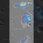
Our Mars Express has revisited one of Mars’s most intriguing features the Medusae Fossae, revealing what seems to be layers of water ice below the dusty surface.
If melted, this potential water would be enough to fill Earth’s Red Sea, or cover Mars in a layer of water up to 2.7 m deep!
📸 Planetary Science Institute/Smithsonian Institution 📸 European Space Agency / DLR / FU Berlin 📸 CReSIS/KU/Smithsonian Institution
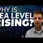
Global sea levels are rising as a result of human-caused global warming, with recent rates being unprecedented over the past 2,500-plus years. NASA JPL’s sea level rise expert Ben Hamlington explains how our warming planet is causing sea levels to rise.
Satellite images of our planet have become essential to our survival, offering a new outlook of our world. With rising seas being one of the biggest threats to society, satellite altimeter missions such as Copernicus Sentinel-6 are essential in monitoring global and regional changes in sea level.
Unbeknown to many, the island of Crete, Greece, plays an important role in the Copernicus satellite altimetry constellation and on an international stage. Satellite altimetry data have to be continuously monitored at the ESA’s Permanent Facility for Altimetry Calibration where different techniques have pioneered the use of transponders to provide the best measurements to validate satellite altimeters in space soon after launch.
This documentary explains how measurements are taken from the top of the White Mountains to make sure users get the best data on sea height from satellite altimetry.
It features interviews with Craig Donlon, Head of ESA’s Earth Surfaces and Interior Earth and Mission Science Division and Stelios Mertikas, Director of Laboratory of Geodesy & Geomatics Engineering at the @Technical University of Crete.
We are Europe’s gateway to space. Our mission is to shape the development of Europe’s space capability and ensure that investment in space continues to deliver benefits to the citizens of Europe and the world. Check out https://www.esa.int/ to get up to speed on everything space related.
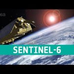
This November the newest member of the EU’s Copernicus programme, Sentinel-6 Michael Freilich, will take to the heavens from Vandenberg Air Force Base in California. The satellite is named after NASA’s former Director of Earth Observation and is a radar altimetry mission to monitor sea-level rise, wave-height and windspeed.
The mission is a collaboration between ESA, the European Commission, EUMETSAT, NASA and NOAA, with support from the French space agency CNES. It will continue a three-decade-long time-series of radar altimetry missions that started with the Topex-Poseidon mission and was then followed by the Jason missions.
★ Subscribe: http://bit.ly/ESAsubscribe and click twice on the bell button to receive our notifications.
We are Europe’s gateway to space. Our mission is to shape the development of Europe’s space capability and ensure that investment in space continues to deliver benefits to the citizens of Europe and the world. Check out https://www.esa.int/ to get up to speed on everything space related.
In a cleanroom in Ottobrunn, Germany, the latest Copernicus Sentinel satellite is ready for final testing before it is packed up and shipped to the US for liftoff next year. Designed and built to chart changing sea level, it is the first of two identical Sentinel-6 satellites that will be launched consecutively to continue the time series of sea-level measurements. This new mission builds on heritage from previous ocean topography satellites, including the French–US Topex-Poseidon and Jason missions, previous ESA missions such as the ERS satellites, Envisat and CryoSat, as well as Copernicus Sentinel-3. With millions of people around the world at risk from rising seas, it is essential to continue measuring the changing height of the sea surface so that decision-makers are equipped to take appropriate mitigating action – as is being currently highlighted at the COP-25 Climate Change Conference in Spain.
We are Europe’s gateway to space. Our mission is to shape the development of Europe’s space capability and ensure that investment in space continues to deliver benefits to the citizens of Europe and the world. Check out http://www.esa.int/ESA to get up to speed on everything space related.
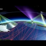
At sea, space technology is used to help save lives every day: managing traffic between ships, picking up migrants and refugees in distress or spotting oil spills. The European Space Agency is once again at the forefront developing new technologies and satellites: to keep us safe at sea and to monitor the environment. Space makes a difference here on Earth and certainly at sea where there is no infrastructure.
Disponer de internet a alta velocidad se ha convertido en una necesidad en cualquier lugar del planeta, ya sea en un pueblo aislado o en un tren. La mejor solución llega desde el espacio: La conexión a internet vía satélite.