In this week’s edition of the Earth from Space programme, Copernicus Sentinel-2 takes us over the Vandenberg Air Force Base, in California, US, where the Copernicus Sentinel-6 Michael Freilich satellite will soon launch from.
Download the image: https://www.esa.int/ESA_Multimedia/Images/2020/11/Vandenberg_Air_Force_Base_California
Tag: Vandenberg Air Force Base
-

Earth from Space: Vandenberg Air Force Base, California
-
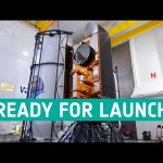
Copernicus Sentinel-6 ready for launch
Final preparations are underway in California for the launch of Sentinel-6 Michael Freilich, a joint European and US satellite designed to take precise measurements of sea-level change. The satellite forms part of the European Union’s Copernicus Earth Observation programme and will employ a radar altimeter to map sea-surface topography. The satellite will provide fundamental data for climate science and policymaking, helping to protect the 600 million people who live in vulnerable coastal areas. It will also deliver near-realtime information for marine and weather forecasts.
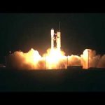
The mission is a collaboration between ESA, the European Commission, EUMETSAT, NASA and NOAA, with support from the French space agency CNES. Scheduled for launch on 21 November on a SpaceX Falcon 9 rocket from the Vandenberg Air Force Base on the California coast, the satellite is named Michael Freilich after NASA’s former Director of Earth Science.
★ Subscribe: http://bit.ly/ESAsubscribe and click twice on the bell button to receive our notifications.
Check out our full video catalog: http://bit.ly/SpaceInVideos
Follow us on Twitter: http://bit.ly/ESAonTwitter
On Facebook: http://bit.ly/ESAonFacebook
On Instagram: http://bit.ly/ESAonInstagram
On Flickr: http://bit.ly/ESAonFlickrWe are Europe’s gateway to space. Our mission is to shape the development of Europe’s space capability and ensure that investment in space continues to deliver benefits to the citizens of Europe and the world. Check out https://www.esa.int/ to get up to speed on everything space related.
Copyright information about our videos is available here: https://www.esa.int/ESA_Multimedia/Terms_and_Conditions
#ESA
#Sentinel6
#SeeingTheSeas -

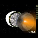
Copernicus Sentinel-6 measuring sea levels using radar altimetry
This November the newest member of the EU’s Copernicus programme, Sentinel-6 Michael Freilich, will take to the heavens from Vandenberg Air Force Base in California. The satellite is named after NASA’s former Director of Earth Observation and is a radar altimetry mission to monitor sea-level rise, wave-height and windspeed.
The mission is a collaboration between ESA, the European Commission, EUMETSAT, NASA and NOAA, with support from the French space agency CNES. It will continue a three-decade-long time-series of radar altimetry missions that started with the Topex-Poseidon mission and was then followed by the Jason missions.
★ Subscribe: http://bit.ly/ESAsubscribe and click twice on the bell button to receive our notifications.
Check out our full video catalog: http://bit.ly/SpaceInVideos
Follow us on Twitter: http://bit.ly/ESAonTwitter
On Facebook: http://bit.ly/ESAonFacebook
On Instagram: http://bit.ly/ESAonInstagram
On Flickr: http://bit.ly/ESAonFlickrWe are Europe’s gateway to space. Our mission is to shape the development of Europe’s space capability and ensure that investment in space continues to deliver benefits to the citizens of Europe and the world. Check out https://www.esa.int/ to get up to speed on everything space related.
Copyright information about our videos is available here: https://www.esa.int/ESA_Multimedia/Terms_and_Conditions
#ESA
#Sentinel6
#SeeingTheSeas -
NASA Launches NOAA Weather Satellite to Improve Forecasts
Early on the morning of Saturday, Nov. 18, NASA successfully launched for the National Oceanic and Atmospheric Administration (NOAA) the first in a series of four advanced polar-orbiting satellites, equipped with next-generation technology and designed to improve the accuracy of U.S. weather forecasts out to seven days. The Joint Polar Satellite System-1 (JPSS-1) lifted off on a United Launch Alliance Delta II rocket from Vandenberg Air Force Base on California’s central coast. JPSS-1 data will improve weather forecasting and help agencies involved with post-storm recovery by visualizing storm damage and the geographic extent of power outages.
This video is available for download from NASA’s Image and Video Library: https://images.nasa.gov/details-NHQ_2017_1118_NASA%20Launches%20NOAA%20Weather%20Satellite%20to%20Improve%20Forecasts.html
-
NASA Earth Science Mission Launches
NASA’s Soil Moisture Active Passive (SMAP) spacecraft launched Jan. 31 from California’s Vandenberg Air Force Base. SMAP is the first U.S. Earth-observing satellite designed to collect global observations of surface soil moisture. The mission’s high resolution space-based measurements of soil moisture will give scientists a new capability to better predict natural hazards of extreme weather and improve our understanding of Earth’s water, energy and carbon cycles.