Tag: weather

  • Advancing weather forecasting in a changing climate

    Advancing weather forecasting in a changing climate

    The effects of the climate crisis are felt more acutely in the Arctic than anywhere else on the planet. The weather in the Arctic is not only severe, but it changes extremely quickly. More frequent data are urgently needed to improve weather forecasts for this susceptible polar region.

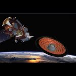
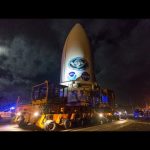
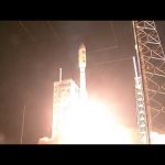
    Enter ESA’s Arctic Weather Satellite: a brand new prototype mission to show exactly how this can be achieved. The satellite will provide precise, short-term weather forecasts for the Arctic region. It is equipped with a 19-channel cross-track scanning microwave radiometer which will provide high-resolution humidity and temperature soundings of the atmosphere in all weather conditions.

    The Arctic Weather Satellite is the forerunner of a potential constellation of satellites, called EPS-Sterna, that ESA would build for Eumetsat if this first prototype Arctic Weather Satellite performs well.

    Credits: ESA – European Space Agency

    ★ Subscribe: http://bit.ly/ESAsubscribe and click twice on the bell button to receive our notifications.

    Check out our full video catalog: http://bit.ly/SpaceInVideos
    Follow us on Twitter: http://bit.ly/ESAonTwitter
    On Facebook: http://bit.ly/ESAonFacebook
    On Instagram: http://bit.ly/ESAonInstagram
    On LinkedIn: https://bit.ly/ESAonLinkedIn
    On Pinterest: https://bit.ly/ESAonPinterest
    On Flickr: http://bit.ly/ESAonFlickr

    We are Europe’s gateway to space. Our mission is to shape the development of Europe’s space capability and ensure that investment in space continues to deliver benefits to the citizens of Europe and the world. Check out https://www.esa.int/ to get up to speed on everything space related.

    Copyright information about our videos is available here: https://www.esa.int/ESA_Multimedia/Terms_and_Conditions

    #ESA #Satellite #ArcticWeatherSatellite

  • Heatwave hits Antarctica ♨️ #shorts

    Heatwave hits Antarctica ♨️ #shorts

    According to the @worldmetorg, July 2023 is likely to have been the hottest month on record. While much of Europe, North America and Asia suffered the immediate consequences of these brutal temperatures, extreme events are also hitting hard far away in the icy reaches of Antarctica. In a paper published today, scientists highlight Antarctica’s vulnerability to extremes and the role that satellites play in monitoring this remote region.

    #ESA
    #Heatwave
    #Antarctica

  • Is There Weather on the Moon? We Asked a NASA Scientist

    Is There Weather on the Moon? We Asked a NASA Scientist

    Is there weather on the Moon? Yes, but not the weather you’re used to. The Sun’s solar wind is a type of “space weather” that can have a big impact on the Moon due to its lack of atmosphere. It can also affect all sorts of things like satellites, electronics and communications. Better understanding how space weather interacts with the Moon will be critical as we send #Artemis astronauts to the lunar surface. https://go.nasa.gov/3WmUB69

    Producers: Jessica Wilde, Scott Bednar
    Editor: James Lucas

    Credit: NASA

  • Launch of JPSS-2 Weather Satellite & LOFTID Mars Tech Demo (Official NASA Broadcast)

    Launch of JPSS-2 Weather Satellite & LOFTID Mars Tech Demo (Official NASA Broadcast)

    Watch live as a new weather forecasting satellite and experimental Mars technology take to the skies.

    The National Oceanic and Atmospheric Administration (NOAA)’s Joint Polar Satellite System-2 (JPSS-2) is now set for launch Thursday, Nov. 10 at 4:25 a.m. EST (0925 UTC).

    The mission will lift off aboard a United Launch Alliance (ULA) Atlas V 401 rocket from Space Launch Complex-3 at Vandenberg Space Force Base in California. JPSS-2 is a new generation polar-orbiting operational environmental satellite system.

    Also aboard the Atlas V 401 rocket will be the secondary payload, NASA’s Low-Earth Orbit Flight Test of an Inflatable Decelerator (LOFTID). LOFTID will demonstrate inflatable heat shield technology for atmospheric entry and re-entry. This technology could enable a variety of proposed NASA missions to destinations such as Mars, Venus, and Titan, as well as returning heavier payloads from low-Earth orbit.

    More on NASA climate science missions: https://nasa.gov/climate

    Credit: NASA

  • NEW Weather Satellite on its way to launch 🛰️

    NEW Weather Satellite on its way to launch 🛰️

    The final pre-launch preparations for the first Meteosat Third Generation (MTG) satellite are underway. The first satellite, called MTG-I1, built by a European industrial consortium led by Thales Alenia Space carries two imagers: an advanced Flexible Combined Imager and, in a first for Europe, a Lightning Imager that will allow the earlier detection of storms and extreme weather events, as well as improve aviation safety.

    Building on the long-standing partnership between ESA and Eumetsat, the MTG-I1 will be one of six satellites operating in a fleet, of three at a time, to ensure the continuity of data from the previous Meteosat satellites over the next 20 years. The first Meteosat was launched in 1977 and this third generation of spacecraft will be the most advanced yet, with improved image resolution and providing close to real time data for users, or ‘nowcasting’ of fast-developing, high-impact weather.

    The launch is currently scheduled for the end of 2022.

    The film includes soundbites from ESA Director of Earth Observation Programmes: Simonetta Cheli, ESA Meteosat Programme Manager: Paul Blythe, ESA Meteosat Third Generation Payload Manager: Donny Aminou and EUMETSAT, Meteosat Third Generation Programme Manager: Alexander Schmid.

    ★ Subscribe: http://bit.ly/ESAsubscribe and click twice on the bell button to receive our notifications.

    Check out our full video catalog: http://bit.ly/SpaceInVideos
    Follow us on Twitter: http://bit.ly/ESAonTwitter
    On Facebook: http://bit.ly/ESAonFacebook
    On Instagram: http://bit.ly/ESAonInstagram
    On LinkedIn: https://bit.ly/ESAonLinkedIn
    On Pinterest: https://bit.ly/ESAonPinterest
    On Flickr: http://bit.ly/ESAonFlickr

    We are Europe’s gateway to space. Our mission is to shape the development of Europe’s space capability and ensure that investment in space continues to deliver benefits to the citizens of Europe and the world. Check out https://www.esa.int/ to get up to speed on everything space related.

    Copyright information about our videos is available here: https://www.esa.int/ESA_Multimedia/Terms_and_Conditions

    #ESA
    #MTG
    #WeatherSatellite

  • Watch NOAA’s GOES-T Weather Satellite Launch to Geostationary Orbit

    Watch NOAA’s GOES-T Weather Satellite Launch to Geostationary Orbit

    We’re ready to GOES – are you? Join us to watch the launch of the National Oceanic and Atmospheric Administration’s (NOAA) next weather observing and environmental monitoring system satellite. The satellite, currently known as GOES-T, will provide critical data to improve weather forecasting and to better track storms and other hazards.

    GOES-T is scheduled for liftoff at 4:38 p.m. EST (21:38 UTC) aboard a United Launch Alliance Atlas V 451 rocket to join our fleet of spacecraft monitoring Earth from space. There is a two-hour launch window. This launch is being managed by NASA’s Launch Services Program based at Kennedy Space Center. NOAA’s Geostationary Operational Environmental Satellites (GOES) constantly monitor weather across the Western Hemisphere, as well as weather in space caused by activity from our Sun.

    Image Credit: United Launch Alliance

  • Weather vs. Climate | Meet the experts

    Weather vs. Climate | Meet the experts

    Ice and snow can be a hot topic when talking about climate. The polar regions are very fragile and can tell us a lot about how Earth’s climate is changing. Andrew Shepherd of the University of Leeds is a leading climate scientist working with ESA and NASA. In this episode he explains how we can separate the effects of weather versus climate from data records and the role of space in studying changes to our planet in real-time and in the future.

    Learn more: http://bit.ly/ExpeditionHome12_18YearsOld

    ★ Subscribe: http://bit.ly/ESAsubscribe and click twice on the bell button to receive our notifications.

    Check out our full video catalog: http://bit.ly/SpaceInVideos
    Follow us on Twitter: http://bit.ly/ESAonTwitter
    On Facebook: http://bit.ly/ESAonFacebook
    On Instagram: http://bit.ly/ESAonInstagram
    On Flickr: http://bit.ly/ESAonFlickr

    We are Europe’s gateway to space. Our mission is to shape the development of Europe’s space capability and ensure that investment in space continues to deliver benefits to the citizens of Europe and the world. Check out http://www.esa.int/ESA to get up to speed on everything space related.

    Copyright information about our videos is available here: http://www.esa.int/spaceinvideos/Terms_and_Conditions

    #ESA
    #MeetTheExperts
    #ExpeditionHome

  • Views of Hurricane Dorian from the International Space Station – September 6, 2019

    Views of Hurricane Dorian from the International Space Station – September 6, 2019

    Cameras outside the International Space Station captured views at 8:10 a.m. Eastern time September 6 of a weakening Hurricane Dorian from 260 miles in altitude as it churned just off the outer banks of North Carolina. In its 8 a.m. EDT advisory, the National Hurricane Center said category 1 Hurricane Dorian is moving toward the northeast near 14 mph with maximum sustained winds of 90 miles an hour. The general motion of Dorian, with an increase in forward speed, is expected through Saturday. On the forecast track, the center of Dorian will move near or over the coast of North Carolina during the next several hours. The center should move to the southeast of extreme southeastern New England tonight and Saturday morning, and then across Nova Scotia late Saturday or Saturday night.

    Dorian should remain a potent hurricane as it moves near or along the coast of North Carolina during the next several hours. Dorian is forecast to become a post-tropical cyclone with hurricane-force winds by Saturday night as it approaches Nova Scotia. Hurricane-force winds extend outward up to 45 miles from the center of the system and tropical-storm-force winds extend outward up to 220 miles.

    Download this video: https://images.nasa.gov/details-iss060m262491204_Expedition_60_Hurricane_Dorian_Flyover_09-06-19.html

    For the latest updates on Hurricane Dorian from NASA, visit: https://blogs.nasa.gov/hurricanes/tag/dorian-2019/

  • Views of Hurricane Dorian from the International Space Station – September 2, 2019

    Views of Hurricane Dorian from the International Space Station – September 2, 2019

    Cameras outside the International Space Station captured views at 11:27 a.m. EDT on Sept. 2 of Hurricane Dorian from 260 miles in altitude as it churned over northwestern Bahamas. In its 11:00 a.m. EDT advisory, the National Hurricane Center said Dorian was almost stationary, moving toward the west at just 1 mile an hour just over 100 miles east of West Palm Beach, Florida, packing catastrophic sustained winds of 155 miles an hour. A slow westward to west-northwestward motion is forecast during the next day or so, followed by a gradual turn toward the northwest and north. On this track, the core of extremely dangerous Hurricane Dorian will continue to pound Grand Bahama Island through much of today and tonight. The hurricane will move dangerously close to the east coast of Florida tonight through Wednesday evening and dangerously close to the Georgia and South Carolina coasts Wednesday night and Thursday. Currently, Dorian is a category 4 hurricane on the Saffir-Simpson Hurricane Wind Scale. Although gradual weakening is forecast, Dorian is expected to remain a powerful hurricane during the next couple of days while moving on a possible track up the southeastern U.S. seaboard.

    Download this footage: https://images.nasa.gov/details-jsc2019m000806_Hurricane_Dorian_190902.html

    For the latest updates on Hurricane Dorian from NASA, visit: https://blogs.nasa.gov/hurricanes/tag/dorian-2019/

  • Views of Hurricane Dorian from the International Space Station – September 1, 2019

    Views of Hurricane Dorian from the International Space Station – September 1, 2019

    Cameras outside the International Space Station captured views September 1 of Hurricane Dorian from 260 miles in altitude at 12:16 p.m. Eastern time as it churned over the Atlantic Ocean over the northern Bahamas. The storm, which is moving in a westerly direction with sustained winds of 180 miles an hour, is a dangerous Category 5 hurricane, carrying the strongest winds in recorded history for the northwestern Bahamas. The National Hurricane Center said in its 11 a.m. EDT advisory that Dorian is inflicting catastrophic damage to the Abacos and Grand Bahama Islands. Dorian is forecast to approach the east coast of Florida before taking a possible track up the southeastern U.S. seaboard later this week.

    Download this video: https://images.nasa.gov/details-jsc2019m000805_Hurricane_Dorian_190901.html

    For the latest updates on Hurricane Dorian from NASA, visit: https://blogs.nasa.gov/hurricanes/tag/dorian-2019/

  • Views of Hurricane Dorian from the International Space Station – August 30, 2019

    Views of Hurricane Dorian from the International Space Station – August 30, 2019

    Cameras outside the International Space Station captured views August 30 of rapidly intensifying Hurricane Dorian at 12:18 p.m. Eastern time as it churned over the Atlantic Ocean. The storm, which is moving to the northwest, is forecast by the National Hurricane Center to approach the east coast of Florida Monday evening as a likely category 4 hurricane.

    To download this video, visit https://images.nasa.gov/details-jsc2019m000803_Hurricane_Dorian_190830.html

    For the latest updates on orbital views of Hurricane Dorian from NASA, visit: https://blogs.nasa.gov/hurricanes/tag/dorian-2019/

  • How NASA Earth Satellites Track Hurricanes

    How NASA Earth Satellites Track Hurricanes

    NASA has a unique and important view of hurricanes around the planet. Satellites and aircraft watch as storms form, travel across the ocean and sometimes, make landfall. After the hurricanes have passed, the satellites and aircraft see the aftermath of hurricanes, from downed forests to mass power loss. Complete transcript available.

    Music credit: “Northern Breeze” by Denis Levaillant [SACEM], “Stunning Horizon” by Maxime Lebidois [SACEM], Ronan Maillard [SACEM], “Magnetic Force” by JC Lemay [SACEM] from Killer Tracks

    This video is public domain and along with other supporting visualizations can be downloaded from the Scientific Visualization Studio at: http://svs.gsfc.nasa.gov/13216

    Credit: NASA’s Goddard Space Flight Center/Joy Ng

  • The Coriolis Effect

    The Coriolis Effect

    The Coriolis effect says that anytime you’re rotating—whether it’s on a playground toy or your home planet—objects moving in straight lines will appear to curve. This bizarre phenomenon affects many things, from the paths of missiles to the formation of hurricanes.

    You may have heard that the Coriolis effect makes water in the bathtub spiral down the drain in a certain way, or that it determines the way that a toilet flushes. That’s actually wrong.

    Although, as you may have noticed while tracking a hurricane on the news, storms in the Northern Hemisphere spin counterclockwise, while those in the Southern Hemisphere spin clockwise. Why do storms spin in different directions depending on their location? And why do they spin in the first place? The answer is the Coriolis effect.

    SUBSCRIBE here: https://www.youtube.com/WhatThePhysics?sub_confirmation=1

    ** PRODUCTION CREDITS
    ————————————————————

    – Host, Producer: Greg Kestin
    – Filming: Greg Kestin
    – Research, Writing: Greg Kestin
    Samia Bouzid

    – Editing, Animating: Samia Bouzid
    Greg Kestin

    – Editorial Input: Julia Cort, Ari Daniel
    – Science consultants: David Holland, Louis Deslauriers, Kerry Emanuel, Daniel Jacob
    – Media: Shutterstock, NASA, ESA
    – Special thanks: Harvard Lecture Demonstration Group (Daniel Davis, Allen Crockett, Daniel Rosenberg)
    – Special thanks: Entire NOVA team
    – From the producers of PBS NOVA © WGBH Educational Foundation – Funding provided by FQXi
    – Music provided by APM

  • Profiling the wind

    Profiling the wind

    ESA’s Earth Explorer Aeolus satellite will be launched later this year to measure the world’s winds from space. The satellite carries one of the most sophisticated instruments ever to be put into orbit: Aladin, which includes two powerful lasers, a large telescope and very sensitive receivers. The laser generates ultraviolet light that is beamed down into the atmosphere to profile the world’s winds – a completely new approach to measuring the wind from space. These vertical slices through the atmosphere, along with information it gathers on aerosols and clouds, will improve our understanding of atmospheric dynamics and contribute to climate research. As well as advancing science, Aeolus will play an important role in improving weather forecasts. The mission will also complement information about the atmosphere being provided by the Copernicus Sentinel missions.

    Visit our website to learn more: http://www.esa.int/Our_Activities/Observing_the_Earth/Aeolus

  • Advanced Weather Satellite Launched into Orbit

    Advanced Weather Satellite Launched into Orbit

    The first spacecraft in a new series of NASA-built advanced geostationary weather satellites launched into orbit aboard a United Launch Alliance Atlas V rocket Nov. 19 from Cape Canaveral Air Force Station in Florida. Once in geostationary orbit, GOES-R will be known as GOES-16 and will provide images of weather patterns and severe storms as regularly as every five minutes or as frequently as every 30 seconds. These images can be used to aid in weather forecasts, severe weather outlooks, watches and warnings, lightning conditions, maritime forecasts and aviation forecasts.

  • Do It Yourself Weather Vane – Sick Science! #074

    Do It Yourself Weather Vane – Sick Science! #074

    Learn more at http://www.stevespanglerscience.com/content/experiment/weather-vane Early weathermen and women didn’t use Doppler radar or computers to forecast the weather, they relied on tools that were much more simple. Take, for instance, the weather vane. You have probably seen weather vanes atop barns, houses, or mailboxes and they are used to show wind direction. Even though weather vanes are usually made of welded metal, you can make an equally functional weather vane using supplies in your own home!

    Want more experiments like this? Check out http://www.stevespanglerscience.com/product/fire-bubbles-exploding-toothpaste-book

    Sick Science™ is a trademark of Steve Spangler, inc.

    © 2012 Steve Spangler Science all rights reserved

  • Weather and Science Day 2011 – Steve Spangler

    Weather and Science Day 2011 – Steve Spangler

    Learn more about the event at http://www.stevespangler.com/special-science-event/weather-and-science-day-2011-erupting-clouds-giant-smoke-rings-and-exploding-trash-cans-captivate-huge-audience/

    Steve Spangler along with his Demo Team and 9News Meteorologist Kathy Sabine, put on the 2nd annual Weather and Science Day at Coors Field in Colorado on May 17th, 2011. Thanks to Colle McVoy, Steve was able to borrow the worlds largest smoke ring launcher to fire 9′ smoke rings into the crowd. 10,000 people showed up for the pre-game event and using Boom Whackers, created the biggest drum circle ever seen… or heard!

  • Weather & Science Day – You Did It

    Weather & Science Day – You Did It

    Hosted by 9News, the Colorado Rockies and Steve Spangler Science, over 7,000 attended the first annual Weather & Science Day at Coors Field. Thanks for your help in setting a new Guinness World Record.

  • Guinness World Record – Largest Physics Lesson

    Guinness World Record – Largest Physics Lesson

    The largest physics lesson involved 5,401 participants who were taught by Steve Spangler Science (USA) during a presentation at Coors Field in Denver, Colorado, USA, on 7 May 2009. The event was part of the 9News Weather & Science Day hosted by Steve Spangler and Kathy Sabine. Guinness World Records™ Adjudicator, Danny Girton, was present at the event to award the new record.