Tag: Copernicus

  • Sentinel-3A prepares for liftoff (4K timelapse)

    Sentinel-3A prepares for liftoff (4K timelapse)

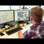
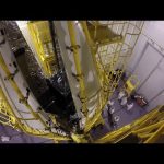
    This timelapse video shows Sentinel-3A, from final preparations to liftoff on a Rockot launcher from the Plesetsk Cosmodrome in northern Russia, at 17:57 GMT (18:57 CET) on 16 February 2016.

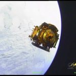
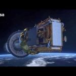
    Sentinel-3A is the third satellite to be launched for Europe’s Copernicus environment monitoring programme.

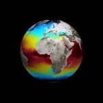
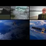
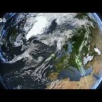
    Designed as a two-satellite constellation – Sentinel-3A and -3B – the Sentinel-3 mission carries a series of cutting-edge instruments for systematic measurements of Earth’s oceans, land, ice and atmosphere. Over oceans, Sentinel-3 measures the temperature, colour and height of the sea surface as well as the thickness of sea ice. These measurements will be used, for example, to monitor changes in sea level, marine pollution and biological productivity. Over land, this innovative mission will monitor wildfires, map the way land is used, provide indices of vegetation state and measure the height of rivers and lakes.

    More about Sentinel-3A: http://esa.int/sentinel-3

    Credits: Directed by Stephane Corvaja, ESA; Edited by Manuel Pedoussaut, Zetapress ; Music by Hubrid-Rockot

  • Sentinels for Copernicus

    Sentinels for Copernicus

    On 16 February 2016 at 18:57 CET (17:57 GMT), Sentinel-3A will be launched on top of a Rockot from the Russian Plesetsk Cosmodrome.

    This satellite will be the third Sentinel for the Copernicus Programme. Copernicus is the most ambitious Earth Observation programme to date. It will provide accurate, timely and easily accessible information to improve the management of the environment, understand and mitigate the effects of climate change and ensure civil security. This initiative is headed by the European Commission (EC) in partnership with the European Space Agency.

    ESA coordinates the delivery of data and is developing a new family of satellites, the Sentinels, specifically for the operational needs of Copernicus. The EC, acting on behalf of the European Union, is responsible for the overall initiative, setting requirements and managing the services. These services fall into six main categories: land management, the marine environment, atmosphere, emergency response, security and climate change.

    This video explains what the Sentinels represent within Copernicus.

  • Sentinel-3: Technology and heritage

    Sentinel-3: Technology and heritage

    ESA’s new Earth observation satellite Sentinel-3A will soon be launched into orbit. Once more the European Space Agency proves it is on the forefront of monitoring our environment and the climate.

    Using state of the art and proven technology the Sentinel-3 satellite is a fabulous piece of engineering set to play a key role in the European Commission’s Copernicus programme. However this technological piece of craftsmanship is only possible as the result of earlier scientific missions such as ERS, Envisat and Cryosat, with Sentinel-3 building on their heritage.

    More about Sentinel-3:
    http://www.esa.int/sentinel-3

  • Earth from Space: Sierra Leone River Estuary

    Earth from Space: Sierra Leone River Estuary

    Earth from Space is presented by Kelsea Brennan-Wessels from the ESA Web-TV virtual studios. Ahead of World Wetlands Day, a wetland of international importance in Sierra Leone is featured in the one hundred seventy-first edition.

    See also http://www.esa.int/spaceinimages/Images/2016/01/Sierra_Leone_River_Estuary to download the image.

  • Earth from Space: Colours of the Persian Gulf

    Earth from Space: Colours of the Persian Gulf

    Earth from Space is presented by Malì Cecere from the ESA Web-TV virtual studios. The one hundred seventieth edition features a Sentinel-2 satellite image of Bahrain and surroundings

    See also http://www.esa.int/spaceinimages/Images/2016/01/Colours_of_the_Persian_Gulf to download the image.

  • Moving ahead with Sentinel-2

    Moving ahead with Sentinel-2

    The green light has been given for all users to have open access to all of the data from ESA’s Sentinel-2A satellite, launched in June for the Copernicus programme.

    This video celebrates Sentinel-2A’s life, from its birth to what it has become today, and what it can give us tomorrow.

    Access Sentinel-2 data:
    https://sentinel.esa.int/web/sentinel/sentinel-data-access

  • ESA Euronews: Space for Earth

    ESA Euronews: Space for Earth

    We have all heard of climate change, but what’s really happening to our planet now, in November 2015? As the COP21 summit in Paris looms in December, we set out to establish some of the scientific fundamentals, and hear how space technology is being used to get a truly global view of Earth’s vital signs.

    Near Les Deux Alps in the French Alps, some 3,200 metres above sea level, we look at how satellite data and glacier measurements can help us to understand the effects of global warming with remote sensing scientist Jean-Pierre Dedieu.

    This video is also available in the following languages:
    French: https://youtu.be/LD2p60ddZKA
    German: https://youtu.be/g-XE_ob_wwY
    Spanish: https://youtu.be/cXFXbpkQ55c
    Italian: https://youtu.be/C1NS2Ro9yZs
    Greek: https://youtu.be/-K6eRtcJKF4
    Portuguese: https://youtu.be/HpCifL61VBA
    Hungarian: https://youtu.be/Qo-j3XJYS6A

  • Safe at sea with satellites

    Safe at sea with satellites

    At sea, space technology is used to help save lives every day: managing traffic between ships, picking up migrants and refugees in distress or spotting oil spills. The European Space Agency is once again at the forefront developing new technologies and satellites: to keep us safe at sea and to monitor the environment. Space makes a difference here on Earth and certainly at sea where there is no infrastructure.

  • Copernicus: Sentinel services

    Copernicus: Sentinel services

    On 23 June 2015 at 01:52 GMT (03:52 CEST 23 June; 22:52 local time 22 June) Sentinel-2A will launch from Europe’s Spaceport in French Guiana on top of a Vega.

    This satellite will be the second Sentinel for the Copernicus Programme. Copernicus is the most ambitious Earth observation programme to date. It will provide accurate, timely and easily accessible information to improve the management of the environment, understand and mitigate the effects of climate change and ensure civil security.

    This initiative is headed by the European Commission (EC) in partnership with the European Space Agency (ESA). ESA coordinates the delivery of data and is developing a new family of satellites, the Sentinels, specifically for the operational needs of Copernicus. The EC, acting on behalf of the European Union, is responsible for the overall initiative, setting requirements and managing the services. These services fall into six main categories: land management, the marine environment, atmosphere, emergency response, security and climate change.

    This video shows a good example of these services with GeoVille, based in Austria, which is playing a key role in Copernicus services for land applications, related to both land cover production as well as downstream services in the spatial planning domain.

  • Onboard camera view: launch and separation of Sentinel-1A

    Onboard camera view: launch and separation of Sentinel-1A

    Cameras mounted on the Soyuz Fregat upper stage that sent Sentinel-1A into space on 3 April 2014 captured this superb footage. It shows liftoff, the various stages in the rocket’s ascent and the Sentinel-1A satellite being released from the Fregat upper stage to start its life in orbit around Earth.

    The 2.3 tonne satellite lifted off on a Soyuz rocket from Europe’s Spaceport in Kourou, French Guiana at 21:02 GMT (23:02 CEST). The first stage separated 118 sec later, followed by the fairing (209 sec), stage 2 (287 sec) and the upper assembly (526 sec). After a 617 sec burn, the Fregat upper stage delivered Sentinel into a Sun-synchronous orbit at 693 km altitude. The satellite separated from the upper stage 23 min 24 sec after liftoff.

    Sentinel-1 is the first in the family of satellites for Europe’s Copernicus programme. It carries an advanced radar to scan Earth’s surface in all weather conditions and regardless of whether it is day or night. This new mission will be used to care for many aspects of our environment, from detecting and tracking oil spills and mapping sea ice to monitoring movement in land surfaces and mapping changes in the way land is used.

  • Sentinel-1A separation in space

    Sentinel-1A separation in space

    This superb footage was acquired by cameras on the Soyuz Fregat upper stage that released Sentinel-1A into orbit on 3 April 2014. It shows the Sentinel-1A satellite separating from the Fregat to start its life in orbit around Earth.

    The 2.3 tonne satellite lifted off on a Soyuz rocket from Europe’s Spaceport in Kourou, French Guiana at 21:02 GMT (23:02 CEST). The first stage separated 118 sec later, followed by the fairing (209 sec), stage 2 (287 sec) and the upper assembly (526 sec). After a 617 sec burn, the Fregat upper stage delivered Sentinel into a Sun-synchronous orbit at 693 km altitude. The satellite separated from the upper stage 23 min 24 sec after liftoff.

    Sentinel-1 is the first in the family of satellites for Europe’s Copernicus programme. It carries an advanced radar to scan Earth’s surface in all weather conditions and regardless of whether it is day or night. This new mission will be used to care for many aspects of our environment, from detecting and tracking oil spills and mapping sea ice to monitoring movement in land surfaces and mapping changes in the way land is used.

    Credits:
    Arianespace/ESA/Roscosmos

  • Sentinel-1 soundtrack

    Sentinel-1 soundtrack

    Sentinel-1A, the first satellite for Europe’s environmental monitoring Copernicus programme, is being launched from Europe’s Spaceport in Kourou, French Guiana on 3 April 2014. It will be lofted into orbit on a Soyuz rocket.

    This animation shows some of the critical stages delivering Sentinel-1 into orbit around Earth. After separating from the Fregat upper stage, the satellite takes around 10 hours to deploy its 12 m-long radar and two 10 m-long solar wings. This deployment sequence is unique, choreographed to ensure that both deploy in the safest possible way. This approach also allows power from the wings to be available as soon as possible so that the satellite is independent.

    Delivering vital information for numerous operational services, from monitoring ice in the polar oceans to tracking land subsidence, Sentinel-1 will play a key role in the largest civil Earth-observation programme ever conceived.

    The animation is set to a track called Sentinel by Mike Oldfield, a world-renowned musician and big space fan.

    Credits:
    Graphics: ESA/ATG medialab; Music written by M. Oldfield/copyright EMI Virgin

  • Why we need radar satellites

    Why we need radar satellites

    The launch of the first Sentinel-1 satellite marks a new paradigm in Earth observation focusing on operational missions to support users for decades to come. This first satellite for Europe’s environmental monitoring Copernicus programme carries an advanced radar to image Earth’s surface no matter what the weather or if it is day or night. Olaf Trieschmann from the European Maritime Safety Agency talks about the need for radar satellites and how data from Sentinel-1 will be used to monitor oil spills and for maritime surveillance. ESA’s Josef Aschbacher talks about how the wide range of services offered through Copernicus will make a step change in the way we manage the environment.

    Credit: ESA/EMSA/European Parliament/DLR/ATG medialab/Funnelweb

  • Sentinel-1: Radar mission

    Sentinel-1: Radar mission

    In early April, Sentinel-1A will be launched from Europe’s Spaceport in French Guiana on a Soyuz launcher. The radar mission is the first of the Copernicus programme, providing an all-weather, day-and-night supply of imagery for Copernicus user services.

  • Copernicus Monitoring the Earth

    Copernicus Monitoring the Earth

    Accurate information about the environmental is crucial. It helps to understand how our planet and climate are changing, the role human activity play in these changes and how this affects our daily lives. Responding to these challenges, the EU and ESA have developed an Earth observation programme called Copernicus, formerly known as Global Monitoring for Environment and Security, – a programme that becomes operational with the launch of Sentinel-1A.

  • ESA Euronews: Copernicus offers a flood of disaster data

    ESA Euronews: Copernicus offers a flood of disaster data

    The recent floods in the UK saw a lot of the management of that disaster made possible by using information from satellites. But how? In this edition of Space we find out.

    Flooding affects thousands of people every year across Europe, and this year one of them just happened to be a flood scientist – Spanish Research Fellow at Reading University in England, Javier García-Pintado.

    His back garden looks onto the Thames, he explains: “This is the bank of the Thames, and this areas was severely affected by the recent flooding. Specifically in this little bit of land we are a tiny bit higher, and we didn’t have any problems, but our neighbours around here certainly did.”

    García-Pintado knew his young family was safe at home, because he could count on his expert knowledge; his day job is using satellite data to improve flood models.

    “As hydrologists we were pretty confident that this property wouldn’t have a problem, and we told our neighbours,” he told euronews.

    Not everyone has a neighbour as knowledgeable as Javier, nor were they as lucky.

    The whole area west of London was affected as England and Wales lived through their wettest winter in almost 250 years.

  • Mike Oldfield sends greeting to ESA and the Sentinel team

    Mike Oldfield sends greeting to ESA and the Sentinel team

    World-renowned musician Mike Oldfield, composer of the music used in ESA’s Sentinel-1 video, is a big space fan. From his home, Mike and his two sons (the future generation of space scientists and explorers) sent this message to ESA and the Sentinel-1 team with best wishes for the upcoming launch.

    Sentinel-1 is an important mission, its launch will mark a new shift in Earth observation, focusing on operational missions to support users for decades to come. This first mission carries an advanced radar sensor to image Earth’s surface through cloud and rain and regardless of whether it is day or night.

    http://www.esa.int/Sentinel-1

    Video copyright: ESA/M. Oldfield
    Sentinel written by M. Oldfield
    Graphics: ESA/ATG medialab
    Music: copyright EMI Virgin