Tag: High Resolution Stereo Camera

  • Fly over Neukum crater

    Fly over Neukum crater

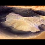
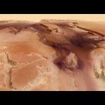
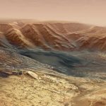
    This movie, based on images taken by ESA’s Mars Express, showcases the 102 km wide Neukum Crater in the southern hemisphere of Mars.

    The crater is named for the German physicist and planetary scientist, Gerhard Neukum, one of the founders of ESA’s Mars Express mission who inspired and led the development of the high-resolution stereo camera on Mars Express.

    This complex impact crater has a diverse geologic history, as indicated by various features on the crater rim and floor. Particularly striking are the dark dune fields, likely made up of volcanic material blown in and shaped by strong winds.

    The crater’s shallow interior has been infilled by sediments over its history. It is also marked with two irregular depressions that may be a sign of a weaker material that has since eroded away, leaving behind some islands of more resistant material.

    Over time the crater rim has undergone varying degrees of collapse, with landslides and slumped material visible in the crater walls. Many smaller craters have also overprinted the rim and pockmarked the interior since Neukum Crater was formed, highlighting its long history.

    Neukum Crater is situated in Noachis Terra, one of the oldest known regions on Mars, dating back to at least 3.9 billion years.

    Credits: Animation: ESA/DLR/FU Berlin, CC BY-SA 3.0 IGO; Music: Coldnoise, CC BY-SA 4.0 and Adrian Neesemann

    ★ Subscribe: http://bit.ly/ESAsubscribe

    Learn more: http://bit.ly/ESACraterNeukum

  • Flying over Becquerel crater

    Flying over Becquerel crater

    Becquerel crater is 167 km in diameter and lies in the Arabia Terra region on Mars, on the boundary between the southern highlands and northern lowlands. This movie shows the location of Becquerel crater on Mars and then provides a flyover of a mound of layered, sulphate-bearing deposits on the crater floor, thought to have formed under the influence of water. The darker material surrounding the mound is wind-blown dust from a source to the north, and provides evidence for effects of wind in eroding the sedimentary deposits.

    The movie was made from a mosaic of four individual images acquired by the High Resolution Stereo Camera on ESA’s Mars Express during orbits 3253/1, 5332, 5350 and 5368. The image is centred at about 22ºN / 352ºE. The average ground resolution is about 17 m per pixel.

    To download the raw images and dtms in GIS-ready formats, please follow this direct link to Becquerel crater on the HRSC mapserver: http://maps.planet.fu-berlin.de/?zoom=7&lat=21.12671&lon=-8.38806&layers=B0TFFFTTT

    Credit: ESA/DLR/FU Berlin, CC BY-SA 3.0 IGO

    Copyright Notice:
    This work is licenced under the Creative Commons Attribution-ShareAlike 3.0 IGO (CC BY-SA 3.0 IGO) licence. The user is allowed to reproduce, distribute, adapt, translate and publicly perform this publication, without explicit permission, provided that the content is accompanied by an acknowledgement that the source is credited as ‘ESA/DLR/FU Berlin’, a direct link to the licence text is provided and that it is clearly indicated if changes were made to the original content. Adaptation/translation/derivatives must be distributed under the same licence terms as this publication. To view a copy of this license, please visit http://creativecommons.org/licenses/by-sa/3.0/igo/

  • The floodwaters of Mars

    The floodwaters of Mars

    Travel across the dramatic flood plains of Mars to celebrate ten years of imaging the Red Planet with Mars Express

    Ten years ago, on 14 January 2004, Mars Express took its very first images of Mars in colour and in 3D.

    To mark the occasion, the team produced a fly-through movie of the ancient flood plain Kasei Valles. The movie is based on the 67-image mosaic released as part of the ten-years-since-launch celebrations in June 2013. See http://www.esa.int/Our_Activities/Space_Science/Mars_Express/The_floodwaters_of_Mars.

    The scene spans 987 km in the north–south direction, 19–36°N, and 1550 km in the east–west direction (280–310°E). It covers 1.55 million square kilometres, an area equivalent to the size of Mongolia.

    Kasei Valles is one of the largest outflow channel systems on Mars, created during dramatic flood events. From source to sink, it extends some 3000 km and descends 3 km.

    Kasei Valles splits into two main branches that hug a broad island of fractured terrain — Sacra Mensa — rising 2 km above the channels that swerve around it. While weaker materials succumbed to the erosive power of the fast-flowing water, this hardier outcrop has stood the test of time.

    Slightly further downstream, the flood waters did their best to erase the 100 km-wide Sharonov crater, crumpling its walls to the south. Around Sharonov many small streamlined islands form teardrop shapes rising from the riverbed as water swept around these natural obstacles.

    The Planetary Science and Remote Sensing Group at Freie Universität Berlin produced the movie. The processing of the High Resolution Stereo Camera image data was carried out at the DLR German Aerospace Center.

    Credit: ESA/DLR/FU Berlin (G. Neukum) / Music: Crabtambour

  • Fly-through movie of Hebes Chasma

    Fly-through movie of Hebes Chasma

    Fly-through movie of Hebes Chasma, the northernmost part of Valles Marineris. The movie was created from images taken by the High Resolution Stereo Camera on Mars Express.

    Copyright: ESA/DLR/FU Berlin (G. Neukum)