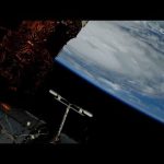
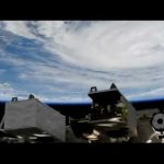
Cameras outside the International Space Station captured views at 8:10 a.m. Eastern time September 6 of a weakening Hurricane Dorian from 260 miles in altitude as it churned just off the outer banks of North Carolina. In its 8 a.m. EDT advisory, the National Hurricane Center said category 1 Hurricane Dorian is moving toward the northeast near 14 mph with maximum sustained winds of 90 miles an hour. The general motion of Dorian, with an increase in forward speed, is expected through Saturday. On the forecast track, the center of Dorian will move near or over the coast of North Carolina during the next several hours. The center should move to the southeast of extreme southeastern New England tonight and Saturday morning, and then across Nova Scotia late Saturday or Saturday night.
Dorian should remain a potent hurricane as it moves near or along the coast of North Carolina during the next several hours. Dorian is forecast to become a post-tropical cyclone with hurricane-force winds by Saturday night as it approaches Nova Scotia. Hurricane-force winds extend outward up to 45 miles from the center of the system and tropical-storm-force winds extend outward up to 220 miles.
Keeping an eye on Hurricane Dorian, the next crew headed to the International Space Station, and a better understanding of Sun-driven space weather … a few of the stories to tell you about – This Week at NASA!
This video is available for download from NASA’s Image and Video Library: https://images.nasa.gov/details-NHQ_2019_0906_Keeping%20an%20eye%20on%20Hurricane%20Dorian%20from%20Space%20on%20This%20Week%20@NASA%20%E2%80%93%20September%206,%202019.html
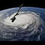
Cameras outside the International Space Station captured views at 11:27 a.m. EDT on Sept. 2 of Hurricane Dorian from 260 miles in altitude as it churned over northwestern Bahamas. In its 11:00 a.m. EDT advisory, the National Hurricane Center said Dorian was almost stationary, moving toward the west at just 1 mile an hour just over 100 miles east of West Palm Beach, Florida, packing catastrophic sustained winds of 155 miles an hour. A slow westward to west-northwestward motion is forecast during the next day or so, followed by a gradual turn toward the northwest and north. On this track, the core of extremely dangerous Hurricane Dorian will continue to pound Grand Bahama Island through much of today and tonight. The hurricane will move dangerously close to the east coast of Florida tonight through Wednesday evening and dangerously close to the Georgia and South Carolina coasts Wednesday night and Thursday. Currently, Dorian is a category 4 hurricane on the Saffir-Simpson Hurricane Wind Scale. Although gradual weakening is forecast, Dorian is expected to remain a powerful hurricane during the next couple of days while moving on a possible track up the southeastern U.S. seaboard.
Cameras outside the International Space Station captured views September 1 of Hurricane Dorian from 260 miles in altitude at 12:16 p.m. Eastern time as it churned over the Atlantic Ocean over the northern Bahamas. The storm, which is moving in a westerly direction with sustained winds of 180 miles an hour, is a dangerous Category 5 hurricane, carrying the strongest winds in recorded history for the northwestern Bahamas. The National Hurricane Center said in its 11 a.m. EDT advisory that Dorian is inflicting catastrophic damage to the Abacos and Grand Bahama Islands. Dorian is forecast to approach the east coast of Florida before taking a possible track up the southeastern U.S. seaboard later this week.
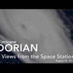
Cameras outside the International Space Station captured views August 30 of rapidly intensifying Hurricane Dorian at 12:18 p.m. Eastern time as it churned over the Atlantic Ocean. The storm, which is moving to the northwest, is forecast by the National Hurricane Center to approach the east coast of Florida Monday evening as a likely category 4 hurricane.
Cameras outside the International Space Station captured views of Hurricane Michael at 12:13 p.m. and 12:50 p.m. EDT Oct. 9 from an altitude of 255 miles as the storm churned over the Gulf of Mexico moving northwest at 12 miles an hour. More: https://go.nasa.gov/2NxKdp4
Michael is expected to make landfall Wednesday, Oct. 10 as a category 3 hurricane over the Florida panhandle.
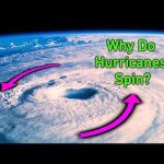
The Coriolis effect says that anytime you’re rotating—whether it’s on a playground toy or your home planet—objects moving in straight lines will appear to curve. This bizarre phenomenon affects many things, from the paths of missiles to the formation of hurricanes.
You may have heard that the Coriolis effect makes water in the bathtub spiral down the drain in a certain way, or that it determines the way that a toilet flushes. That’s actually wrong.
Although, as you may have noticed while tracking a hurricane on the news, storms in the Northern Hemisphere spin counterclockwise, while those in the Southern Hemisphere spin clockwise. Why do storms spin in different directions depending on their location? And why do they spin in the first place? The answer is the Coriolis effect.
Major hurricane Florence, seen from space, our mission to size up land and sea ice on Earth, and “catching big air” … another successful test for our Orion spacecraft … a few of the stories to tell you about – This Week at NASA!
This video is available for download from NASA’s image and Video Library: https://images.nasa.gov/details-Watching Hurricane Florence from Space on This Week @NASA – September 15, 2018.html
A high definition camera outside the International Space Station captured a stark and sobering view of Hurricane Florence at 7:50 a.m. EDT on Sept. 12. NASA satellites track the storm: https://go.nasa.gov/2CEmDGQ
This video was taken as Florence churned across the Atlantic in a west-northwesterly direction with winds of 130 miles an hour. The National Hurricane Center forecasts additional strengthening for Florence before it reaches the coastline of North Carolina and South Carolina early Friday, Sept. 14.
At 8:10 a.m. Eastern time, Sept. 10, cameras on the International Space Station captured views of Hurricane Florence. NASA satellites track the storm: https://go.nasa.gov/2CEmDGQ | Download video: https://go.nasa.gov/2Ql555y
Florence is moving in a westerly direction across the Atlantic, headed for a likely landfall along the eastern seaboard of the U.S. late Thursday or early Friday. Now a major hurricane with winds of 115 miles an hour and increasing, the National Hurricane Center says Florence’s forecast track will take the system over the southwestern Atlantic Ocean between Bermuda and the Bahamas Tuesday and Wednesday, and Florence will approach the coast of South Carolina or North Carolina on Thursday. The station was flying 255 miles over the storm at the time this video was captured.
Satellite data continues to enable weather forecasters to look inside and outside of powerful hurricanes. Imagery from NOAA’s GOES East satellite, captured Sept. 17 to Sept. 20, shows Hurricane Jose along the U.S. east coast, and Hurricane Maria, as it moved through the Leeward Islands, strengthening to a Category 5 hurricane, and making landfall in Puerto Rico. Meanwhile, The Global Precipitation Measurement (GPM) satellite found rain falling inside Maria at a rate of over 6.44 inches per hour in powerful storms that reached above 9.7 miles high. Also, SpaceX Dragon Returns with Science, Katherine Johnson Research Facility Opened, Earth’s Gravity Assist to OSIRIS-REx, Hubble Spots Asteroids Orbiting Each Other, and Engineering the Future!
The National Hurricane Center (NHC) upgraded the remnants of tropical storm Harvey to a tropical depression on August 23, 2017 at 11 a.m. EDT (1500 UTC). Harvey became better organized and was revived after moving from Mexico’s Yucatan Peninsula into the Bay of Campeche. The warm waters of the Gulf of Mexico and favorable vertical wind shear promoted the regeneration of the tropical cyclone. This video includes views from The International Space Station recorded on August 24, 2017 at 6:15 p.m. Eastern Time.
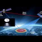
NASA held a media briefing on Nov. 10 at the agency’s headquarters to discuss the upcoming Cyclone Global Navigation Satellite System (CYGNSS) mission. GYGNSS is a constellation of eight microsatellites that will gather never-before-seen details on the formation and intensity of tropical cyclones and hurricanes.
CYGNSS, targeted for a Dec. 12 launch from Cape Canaveral Air Force Station in Florida, is the first mission competitively selected by NASA’s Earth Venture program. This program focuses on low-cost, science-driven missions to enhance our understanding of the current state of Earth and its complex, dynamic system and enable continual improvement in the prediction of future changes.
An animation of satellite observations from Oct. 21-30, 2012, shows the birth of Tropical Storm Sandy in the Caribbean Sea, the intensification and movement of Sandy in the Atlantic Ocean along the U.S. East Coast, and the landfall of Hurricane Sandy in New Jersey on Oct. 29. This visualization was created by the NASA GOES Project at NASA Goddard Space Flight Center, Greenbelt, Md., using observations from NOAA’s GOES-13 and GOES-15 satellites.