Tag: Satellite Images

  • Total solar eclipse seen from space 🌚 #shorts

    Total solar eclipse seen from space 🌚 #shorts

    A total solar eclipse swept across North America yesterday, blocking out the Sun momentarily with parts of the continent plunged into darkness. Geostationary satellites orbiting 36 000 km away captured images of the rare celestial event.

    These images, captured by the Geostationary Operational Environmental Satellite (GOES-16), captured the moon’s shadow moving across North America from approximately 16:00 to 23:00 CEST (15:00 to 22:00 BST.)

    A total solar eclipse occurs when the Moon passes between the Sun and Earth and, for a short period, blocks the face of the Sun, save for a visible ring of light, known as the Sun’s corona.

    The track of the moon’s shadow across Earth’s surface, called the path of totality, spanned across the North American continent – from Mexico to the very eastern tip of Canada.

    The GOES series is a collaborative development and acquisition effort between National Oceanic and Atmospheric Administration (NOAA) and NASA. The GOES-16 (GOES-East) satellite, the first of the series, provides continuous imagery and atmospheric measurements of Earth’s western hemisphere and monitors space weather.

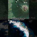
    The Copernicus Sentinel-3 mission also captured images of the eclipse with its Sea and Land Surface Temperature Radiometer (SLSTR).

    The eclipse also acts as a laboratory for researching what happens to weather when the Moon’s shadow passes over. The shadow makes air temperatures drop and can cause clouds to evolve in different ways. Data from GOES, Sentinel-3 and other satellites are now being used to explore these effects.

    Credits: ESA (Data: NOAA)

    #ESA #SolarEclipse #EarthObservation

  • A game show with satellite images? Yes, please! 🙋‍♀️🙋 #shorts

    A game show with satellite images? Yes, please! 🙋‍♀️🙋 #shorts

    Chiara’s favourite satellite image is a rare (and almost cloud-free) view of the remote Elephant Island, in Antarctica.

    This Copernicus Sentinel-2 image was captured a year ago and the full image has a 10 m resolution!

    Do you agree with Chiara’s choice?

    📸 Italy, South Georgia Island, Elephant Island: contains modified Copernicus Sentinel data (2016, 2018, 2023), processed by ESA, Creative Commons BY-SA 3.0 IGO.

    📸Namib Desert, Taranaki: KARI / ESA

    #ESA #Satellite #EarthFromSpace

  • Striking lightning from 36 000 km away

    Striking lightning from 36 000 km away

    Discover the first results from Europe’s first Lightning Imager onboard the Meteosat Third Generation. The Lightning Imager can continuously detect rapid flashes of lighting in Earth’s atmosphere whether day or night from a distance of 36 000 km.

    This is the first time a geostationary weather satellite has the capability to detect lightning across Europe, Africa and the surrounding waters. Each camera can capture up to 1000 images per second and will continuously observe lightning activity from space. The data will give weather forecasters greater confidence in their predictions of severe storms.

    For more information on the Lightning Imager first data, click here: https://www.esa.int/Applications/Observing_the_Earth/Meteorological_missions/meteosat_third_generation

    The full list of animations are available here: https://www.esa.int/ESA_Multimedia/Sets/MTG_Lightning_Imager_animations

    Credits: ESA – European Space Agency

    ★ Subscribe: http://bit.ly/ESAsubscribe and click twice on the bell button to receive our notifications.

    Check out our full video catalog: http://bit.ly/SpaceInVideos
    Follow us on Twitter: http://bit.ly/ESAonTwitter
    On Facebook: http://bit.ly/ESAonFacebook
    On Instagram: http://bit.ly/ESAonInstagram
    On LinkedIn: https://bit.ly/ESAonLinkedIn
    On Pinterest: https://bit.ly/ESAonPinterest
    On Flickr: http://bit.ly/ESAonFlickr

    We are Europe’s gateway to space. Our mission is to shape the development of Europe’s space capability and ensure that investment in space continues to deliver benefits to the citizens of Europe and the world. Check out https://www.esa.int/ to get up to speed on everything space related.

    Copyright information about our videos is available here: https://www.esa.int/ESA_Multimedia/Terms_and_Conditions

    #ESA
    #Lightning
    #Satellite

  • ESA and climate change

    ESA and climate change

    Climate change is high on the global agenda.
    To tackle climate change, a global perspective is needed and this can be provided by satellites. Their data is key if we want to prepare ourselves for the consequences of climate change. While our Earth Explorers gather data to understand how our planet works and understand the impact that climate change and human activity are having on the planet, the European Union’s Copernicus Sentinels provide systematic data for environmental services that help adapt to and mitigate change.
    The video offers an overview of how European satellites keep watch over our world. It includes interviews with Josef Aschbacher, our Director of Earth Observation Programmes, and Michael Rast, our Earth Observation Senior Advisor.

    ★ Subscribe: http://bit.ly/ESAsubscribe and click twice on the bell button to receive our notifications.

    Check out our full video catalog: http://bit.ly/SpaceInVideos
    Follow ESA on Twitter: http://bit.ly/ESAonTwitter
    On Facebook: http://bit.ly/ESAonFacebook
    On Instagram: http://bit.ly/ESAonInstagram
    On Flickr: http://bit.ly/ESAonFlickr

    ESA is Europe’s gateway to space. Our mission is to shape the development of Europe’s space capability and ensure that investment in space continues to deliver benefits to the citizens of Europe and the world. Check out http://www.esa.int/ESA to get up to speed on everything space related.

    Copyright information about our videos is available here: http://www.esa.int/spaceinvideos/Terms_and_Conditions

    #ESA
    #Earth
    #ClimateChange

  • Carbon dioxide ocean–atmosphere exchange

    Carbon dioxide ocean–atmosphere exchange

    Atmospheric carbon dioxide is the most important human-made greenhouse gas responsible for global warming. Oceans assist in removing carbon dioxide from the atmosphere: phytoplankton accumulate carbon dioxide through photosynthesis and their chlorophyll colours the ocean’s waters. Satellites use this colour to measure chlorophyll, which helps scientists to calculate how much carbon dioxide is absorbed or emitted.

    Copyright: Planetary Visions (credit: ESA/CCI Ocean Colour/Climate Monitoring User Group/Planetary Visions)