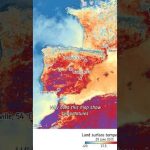
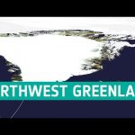
Satellites like Copernicus Sentinel-3 measure land surface temperature — that’s the heat coming directly from the ground, not the air above it. And yes, it’s often hotter in the summer than what your app tells you.
📹 European Space Agency (ESA) 📸 Contains modified Copernicus Sentinel data (2025), processed by ESA
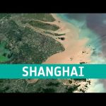
Shanghai, China is a significant global financial centre and it is also the site of one of the worlds busiest container ports because of its strategic location on the Yangtze River delta.
We are Europe’s gateway to space. Our mission is to shape the development of Europe’s space capability and ensure that investment in space continues to deliver benefits to the citizens of Europe and the world. Check out https://www.esa.int/ to get up to speed on everything space related.
This week’s edition of the Earth from Space programme features a Copernicus Sentinel-3 image showing the scale of Britain’s heatwave as it baked in extreme temperatures in August.
We are Europe’s gateway to space. Our mission is to shape the development of Europe’s space capability and ensure that investment in space continues to deliver benefits to the citizens of Europe and the world. Check out https://www.esa.int/ to get up to speed on everything space related.
The series of heatwaves we are currently experiencing in western Europe is a clear sign of human-induced global warming. ESA’s Clement Albergel explains how we monitor these events using satellites such as the Copernicus Sentinel-3 mission and puts them in the context of the long-term climate data record generated via ESA’s Climate Change Initiative.
Credits: ESA
★ Subscribe: http://bit.ly/ESAsubscribe and click twice on the bell button to receive our notifications.
We are Europe’s gateway to space. Our mission is to shape the development of Europe’s space capability and ensure that investment in space continues to deliver benefits to the citizens of Europe and the world. Check out https://www.esa.int/ to get up to speed on everything space related.
We are Europe’s gateway to space. Our mission is to shape the development of Europe’s space capability and ensure that investment in space continues to deliver benefits to the citizens of Europe and the world. Check out https://www.esa.int/ to get up to speed on everything space related.
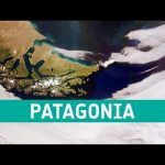
This week’s edition of the Earth from Space programme features an impressive, wide-angled view of Patagonia and the Falkland Islands (Islas Malvinas), captured by the Copernicus Sentinel-3 mission.
We are Europe’s gateway to space. Our mission is to shape the development of Europe’s space capability and ensure that investment in space continues to deliver benefits to the citizens of Europe and the world. Check out https://www.esa.int/ to get up to speed on everything space related.
This week’s edition of the Earth from Space programme features an impressive shot of the almost cloud-free Scandinavian Peninsula captured by the Copernicus Sentinel-3 mission.
We are Europe’s gateway to space. Our mission is to shape the development of Europe’s space capability and ensure that investment in space continues to deliver benefits to the citizens of Europe and the world. Check out https://www.esa.int/ to get up to speed on everything space related.
We are Europe’s gateway to space. Our mission is to shape the development of Europe’s space capability and ensure that investment in space continues to deliver benefits to the citizens of Europe and the world. Check out https://www.esa.int/ to get up to speed on everything space related.
We are Europe’s gateway to space. Our mission is to shape the development of Europe’s space capability and ensure that investment in space continues to deliver benefits to the citizens of Europe and the world. Check out http://www.esa.int/ESA to get up to speed on everything space related.
We are Europe’s gateway to space. Our mission is to shape the development of Europe’s space capability and ensure that investment in space continues to deliver benefits to the citizens of Europe and the world. Check out http://www.esa.int/ESA to get up to speed on everything space related.
We are Europe’s gateway to space. Our mission is to shape the development of Europe’s space capability and ensure that investment in space continues to deliver benefits to the citizens of Europe and the world. Check out http://www.esa.int/ESA to get up to speed on everything space related.
We are Europe’s gateway to space. Our mission is to shape the development of Europe’s space capability and ensure that investment in space continues to deliver benefits to the citizens of Europe and the world. Check out http://www.esa.int/ESA to get up to speed on everything space related.
ESA is Europe’s gateway to space. Our mission is to shape the development of Europe’s space capability and ensure that investment in space continues to deliver benefits to the citizens of Europe and the world. Check out http://www.esa.int/ESA to get up to speed on everything space related.
ESA is Europe’s gateway to space. Our mission is to shape the development of Europe’s space capability and ensure that investment in space continues to deliver benefits to the citizens of Europe and the world. Check out http://www.esa.int/ESA to get up to speed on everything space related.
ESA is Europe’s gateway to space. Our mission is to shape the development of Europe’s space capability and ensure that investment in space continues to deliver benefits to the citizens of Europe and the world. Check out http://www.esa.int/ESA to get up to speed on everything space related.
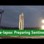
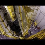
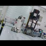
See in this time-lapse how the Sentinel-3B satellite was prepared for its liftoff on 25 April 2018 from Plesetsk in Russia.
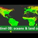
Sentinel-3B joined its twin, Sentinel-3A, in orbit. The pairing of identical satellites provides the best coverage and data delivery for Europe’s Copernicus programme – the largest environmental monitoring programme in the world. The satellites carry the same suite of cutting-edge instruments to measure oceans, land, ice and atmosphere.
Credits: Directed by Stephane Corvaja, ESA; Edited by Manuel Pedoussaut, Zetapress; Music by Hubrid-Rockot
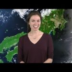
Earth from Space is presented by Kelsea Brennan-Wessels from the ESA Web TV virtual studios. A mosaic of cloud-free images from the Copernicus Sentinel-3A satellite spanning Europe is featured in this edition.
The Copernicus Sentinel-3B satellite spent six weeks at the Plesetsk cosmodrome in Russia being carefully prepared for liftoff. After being shipped from France to the launch site, the satellite was tested, joined to the rocket launch adapter, sealed from view in the fairing and taken by train to the launch pad. Sentinel-3B lifted off on 25 April 2018 at 17:57 GMT (19:57 CEST).
It joins its twin, Sentinel-3A, in orbit. The pairing of identical satellites provides the best coverage and data delivery for Europe’s Copernicus programme – the largest environmental monitoring programme in the world. The satellites carry the same suite of cutting-edge instruments to measure oceans, land, ice and atmosphere. While these data are fed primarily into the Copernicus Marine Environment Monitoring Service, all the Copernicus services benefit to produce knowledge and information products in near-real time for a wide range of applications. The Sentinel-3 mission is essential for applications for ocean and coastal monitoring, numerical weather and ocean prediction, sea-level change and sea-surface topography monitoring, ocean primary production estimation and land-cover change mapping.
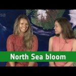
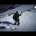
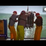
We meet a surfing scientist and toxic algae hunters to see how Sentinel-3 satellite data is used to study the coastline of the English Channel in this month’s episode of Space.
Bob Brewin is pioneering a new technique in satellite oceanography – by going surfing. The Plymouth Marine Laboratory scientist uses his board to take sea surface temperature measurements, and then use them to better interpret data from European satellite Sentinel-3.
Having a stressful day? We got you covered! Sit back, turn the volume up and enjoy a relaxing moment brought to you by ESA and Lufthansa exploring the countries which make up the European Space Agency with images taken by the Copernicus Sentinel-1A, Sentinel-2A and Sentinel-3A, Proba-V and Envisat satellites.
Don’t forget to favourite this video. You will always have a space to relax with us.
Earth from Space is presented by Kelsea Brennan-Wessels from the ESA Web TV virtual studios. In this edition, Sentinel-3A treats us to a view stretching from Sardinia to Romania.
Following its launch in February 2016 and subsequent commissioning phase, the Copernicus Sentinel-3A satellite has been systematically measuring our oceans, land, ice and atmosphere. The information feeds a range of practical applications and is used for monitoring and understanding large-scale global dynamics. Sentinel-3A will soon be joined in orbit by its identical twin, Sentinel-3B. Both satellites carry a suite of cutting-edge instruments to supply a new generation of data products, which are particularly useful for marine applications. For example, they monitor ocean-surface temperatures for ocean and weather forecasting services, aquatic biological productivity, ocean pollution and sea-level change. The mission also delivers unique and timely information about changing land cover, vegetation, urban heat islands, and for tracking wildfires. With the two satellites in orbit, global coverage and data delivery will be optimised.
Discover more about our planet with the Earth from Space video programme. In this special edition, senior scientist at France’s Collecte Localisation Satellites, Marie-Hélène Rio, joins the show to discuss how data on ocean surface currents by the Sentinel-3 satellite mission are used by people working at sea.
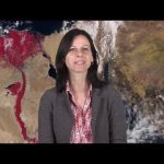
Earth from Space is presented by Malì Cecere from the ESA Web-TV virtual studios. The one hundred eightieth edition features a Sentinel-3A image of the River Nile and surroundings.
This timelapse video shows Sentinel-3A, from final preparations to liftoff on a Rockot launcher from the Plesetsk Cosmodrome in northern Russia, at 17:57 GMT (18:57 CET) on 16 February 2016.
Sentinel-3A is the third satellite to be launched for Europe’s Copernicus environment monitoring programme.
Designed as a two-satellite constellation – Sentinel-3A and -3B – the Sentinel-3 mission carries a series of cutting-edge instruments for systematic measurements of Earth’s oceans, land, ice and atmosphere. Over oceans, Sentinel-3 measures the temperature, colour and height of the sea surface as well as the thickness of sea ice. These measurements will be used, for example, to monitor changes in sea level, marine pollution and biological productivity. Over land, this innovative mission will monitor wildfires, map the way land is used, provide indices of vegetation state and measure the height of rivers and lakes.
On 16 February 2016 at 18:57 CET (17:57 GMT), Sentinel-3A will be launched on top of a Rockot from the Russian Plesetsk Cosmodrome.
This satellite will be the third Sentinel for the Copernicus Programme. Copernicus is the most ambitious Earth Observation programme to date. It will provide accurate, timely and easily accessible information to improve the management of the environment, understand and mitigate the effects of climate change and ensure civil security. This initiative is headed by the European Commission (EC) in partnership with the European Space Agency.
ESA coordinates the delivery of data and is developing a new family of satellites, the Sentinels, specifically for the operational needs of Copernicus. The EC, acting on behalf of the European Union, is responsible for the overall initiative, setting requirements and managing the services. These services fall into six main categories: land management, the marine environment, atmosphere, emergency response, security and climate change.
This video explains what the Sentinels represent within Copernicus.
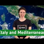
We have all heard of climate change, but what’s really happening to our planet now, in November 2015? As the COP21 summit in Paris looms in December, we set out to establish some of the scientific fundamentals, and hear how space technology is being used to get a truly global view of Earth’s vital signs.
Near Les Deux Alps in the French Alps, some 3,200 metres above sea level, we look at how satellite data and glacier measurements can help us to understand the effects of global warming with remote sensing scientist Jean-Pierre Dedieu.
Sentinel-3A’s preparation is finished and the satellite will soon be shipped to the Russian Cosmodrome of Plesetsk, in Northern Russia for its launch on top of a Rockot planned end of this year. Carrying a suite of state-of-the-art instruments, Sentinel-3 is set to play a key role in Copernicus, the world’s largest environmental monitoring programme operated by the European Commission. It will provide highly accurate measurements on Earth’s oceans, land, ice and atmosphere.
Plymouth is one of England’s historic port cities, a place from which sailors, soldiers and scientists have set off to sea for centuries. Today there’s a new twist to the tale though, as oceanographers now have a huge fleet of satellites in space to add to their list of high quality data sources in order to study and understand our seas.
The field of satellite ocean observation is due to get a boost later this year as ESA’s Sentinel-3 will join the fleet of Earth observers already in orbit. It’s part of Europe’s Copernicus programme, and heralds a new era in ocean observation by offering an uninterrupted flow of data from its speedy polar orbit, now and well into the future.
Az Európai Űrügynökség hamarosan felbocsátja a Sentinel-3 műholdat, amelynek egyik fő feladata az lesz, hogy az óceánokról gyűjtsön adatokat.
Régóta tudjuk hogy az óceánok alapvető fontosságúak a földi élet szempontjából, és ezek szabályozzák az időkárást és a klímát. De most a műholdak segítségével ezt globális léptékben figyelhetjük meg. Egy műhold egy nap alatt annyi adatot szolgáltat az óceánokról, mint egy hajó egy év alatt. Ezeket az ismereteket azonban össze kell vetni a felszínen végzett mérésekkel.
Hogyan is történik mindez: például az űrből megfigyelhető az óceán színe, ami következtetni enged a fitoplankton, egy apró algaféle mennyiségére. Ezek az apró jószágok bocsátják ki a Föld oxigéntermelésének felét, ezek a tengeri ökoszisztéma alapvető építőkockái, ugyanakkor jelzőrendszerként is funkcionálnak, mert nagyon érzékenyen reagálnak a környezet változásaira. Ugyanakkor csak mintavétellel lehet megmondani, hogy mi is az, amit a műhold a a földkörüli pályáról lát.
Ezeknek a kutatásoknak köszönhetően tudjuk, hogyan változik a vízsszint, az óceánok hőmérséklete, az élővilág állapota: ha kellő mennyiségű adat gyűlik össze, abból sokkal inkább megérthetjük a Föld klimatikus viszonyait és folyamatait, mint bármi másból.