003 – Geology
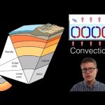
In this video Paul Andersen explains how rock is formed and changed on the planet. The video begins with a brief description of rocks, minerals, and the rock cycle. Plate tectonics is used to describe structure near plate boundaries. Hot spots and natural hazards (like volcanos, earthquake, and tsunamis) are included.
Do you speak another language? Help me translate my videos:
http://www.bozemanscience.com/translations/
Music Attribution
Intro
Title: I4dsong_loop_main.wav
Artist: CosmicD
Link to sound: http://www.freesound.org/people/CosmicD/sounds/72556/
Creative Commons Atribution License
Outro
Title: String Theory
Artist: Herman Jolly
http://sunsetvalley.bandcamp.com/track/string-theory
All of the images are licensed under creative commons and public domain licensing:
Benbennick, David. English: This Is a Locator Map Showing Kalawao County in Hawaii. For More Information, See Commons:United States County Locator Maps., February 12, 2006. Own work: English: The maps use data from nationalatlas.gov, specifically countyp020.tar.gz on the Raw Data Download page. The maps also use state outline data from statesp020.tar.gz. The Florida maps use hydrogm020.tar.gz to display Lake Okeechobee. https://commons.wikimedia.org/wiki/File:Map_of_Hawaii_highlighting_Kalawao_County.svg.
“Earth.” Wikipedia, the Free Encyclopedia, August 23, 2015. https://en.wikipedia.org/w/index.php?title=Earth&oldid=677456791.
File:Structure Volcano Unlabeled.svg, n.d. https://commons.wikimedia.org/wiki/File:Structure_volcano_unlabeled.svg.
Fir0002. A Diagram of the Rock Cycle That Is Modified off of Rockcycle.jpg by User:Woudloper. The Changes Made to This Photo Were Made according to the Conversation at Where the Original Is Being Nominated for Featured Picture Status. It Is Very Important That You Change the Chance of You Getting a Rock of Bandshoe Very Rare Rock Very Costly Too There Are Only 3 Every like It in the World and It Costs 3 Gold Mines and the Mountains Ontop of Them., February 10, 2008. Own work. https://video.kidibot.ro/wp-content/uploads/2023/06/localimages/a-3ERockcycle_edit.jpg.
“Gneiss.” Wikipedia, the Free Encyclopedia, July 29, 2015. https://en.wikipedia.org/w/index.php?title=Gneiss&oldid=673627696.
H.Stauffer, Brian F. Atwater, Marco Cisternas V. , Joanne Bourgeois, Walter C. Dudley, James W. Hendley II, and Peter. English: Vertical Slice Through a Subduction Zone, 1999. U.S. Geological Survey, Circular 1187 (http://pubs.usgs.gov/circ/c1187/illustrations/BlockDigrm_1.ai). https://commons.wikimedia.org/wiki/File:Eq-gen1.svg.
Karta24. Français: Trois Différents Types de Faille, January 20, 2008. http://earthquake.usgs.gov/learn/glossary/?term=fault earthquake.usgs.gov. https://commons.wikimedia.org/wiki/File:Fault_types.svg.
Khruner. English: commons.wikimedia.org/wiki/File:Rocks_-_Pink_granite_Baveno.JPG.
“Landslide.” Wikipedia, the Free Encyclopedia, August 27, 2015. https://en.wikipedia.org/w/index.php?title=Landslide&oldid=678171434.
USGS, derivative work: AnasofiapaixaoEarth_internal_structure png: English: Cutaway Diagram of Earth’s Internal Structure (to Scale) with Inset Showing Detailed Breakdown of Structure (not to Scale), April 27, 2013. Earth_internal_structure.png. https://commons.wikimedia.org/wiki/File:Earth-cutaway-schematic-english.svg.Own work. https://video.kidibot.ro/wp-content/uploads/2023/06/localimages/a-3EHalema-2527uma-2527u_Crater_in_Kilauea_volcano-2C_Hawaii..jpg.

Leave a Reply