Tag: antarctic

  • Flight Over a Rectangular Iceberg in the Antarctic

    Flight Over a Rectangular Iceberg in the Antarctic

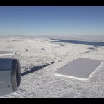
    Can you spot the sharp-angled, rectangular iceberg? This footage (partially sped up) is from an Oct. 16, 2018 flight over the northern Antarctic Peninsula by our Operation IceBridge DC-8 aircraft. Mission Scientist John Sonntag provides commentary. More: https://go.nasa.gov/2JdEy71

    Operation IceBridge is NASA’s longest-running aerial survey of polar ice. During the survey, designed to assess changes in the ice height of several glaciers draining into the Larsen A, B and C embayments, IceBridge senior support scientist Jeremy Harbeck saw a very sharp-angled, tabular iceberg floating among sea ice just off of the Larsen C ice shelf. A photo of the iceberg (seen at right) was widely shared after it was posted on social media.

  • Larsen-C crack

    Larsen-C crack

    The Copernicus Sentinel-1 satellite mission is monitoring the growing crack in Antarctica’s Larsen-C ice shelf. When the ice shelf breaks off or ‘calves’, it will create one of the largest icebergs ever recorded – but exactly how long this will take is difficult to predict.

    This animation demonstrates how scientists analyse radar data from Sentinel-1 to monitor the crack. This includes combining radar images to create an ‘interferogram’. Learn more: http://www.esa.int/spaceinimages/Images/2017/04/Larsen-C_crack_interferogram

    Credits: contains modified Copernicus Sentinel data (2017), processed by A. Hogg/CPOM/Priestly Centre, CC BY-SA 3.0 IGO

  • Changes in ice volume

    Changes in ice volume

    This animation shows changes in ice volume in Antarctica, Greenland and the Arctic ocean measured by the CryoSat satellite, 2010–15. CryoSat’s readings also contribute to our knowledge of global ocean depth.

    More about CryoSat:
    http://www.esa.int/Our_Activities/Observing_the_Earth/CryoSat

    Credit: ESA/CPOM/UCL/D Sandwell/Planetary Visions