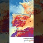
Satellites like Copernicus Sentinel-3 measure land surface temperature — that’s the heat coming directly from the ground, not the air above it. And yes, it’s often hotter in the summer than what your app tells you.
📹 European Space Agency (ESA) 📸 Contains modified Copernicus Sentinel data (2025), processed by ESA
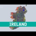
As recently reported by Copernicus ECMWF in its European State of the Climate Report, Europe experienced several climate extremes like glacier ice loss, severe floods, wildfires, and heatwaves. But the continent didn’t experience the same weather uniformly: data show a distinct east‑west contrast during 2024, with eastern areas generally sunny and warm while western areas were cloudier and wetter.
📹 European Space Agency (ESA) 📸 Contains modified CopernicusEU Sentinel data (2022 & 2024), processed by ESA CC BY-SA 3.0 IGO 📊 C3S/Copernicus ECMWF/KNMI
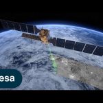
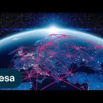
Meet Copernicus Sentinel-1 – this ground-breaking mission delivers continuous, all-weather, day-and-night imaging for land, ice and maritime monitoring.
Equipped with state-of-the-art C-band synthetic aperture radar (SAR), Sentinel-1 captures high-resolution data around the clock, in any weather, making it indispensable for detecting the subtle changes on Earth’s surface that remain hidden from the human eye.
Sentinel-1 data serves a multitude of critical applications: from ensuring the safety and efficiency of maritime traffic, tracking sea ice and icebergs, to monitoring structural integrity and natural hazards, such as earthquakes, landslides and volcanic activity.
Its enhanced radar technology provides precises precise information on ground movement, which is critical for urban planning, infrastructure resilience, subsidence risk assessment and geohazard monitoring.
Through consistent, long-term data collection, Sentinel-1 serves as a global asset, essential for environmental and safety monitoring worldwide. The mission is a beacon of innovation, advancing our understanding of our planet’s dynamic landscape.
This video features interviews with Mark Drinkwater, Head of Mission Sciences Division at ESA, Ramon Torres Cuesta, Sentinel-1 Project Manager at ESA and Julia Kubanek, Sentinel-1 Mission Scientist at ESA.
Credit: ESA – European Space Agency
★ Subscribe: http://bit.ly/ESAsubscribe and click twice on the bell button to receive our notifications.
We are Europe’s gateway to space. Our mission is to shape the development of Europe’s space capability and ensure that investment in space continues to deliver benefits to the citizens of Europe and the world. Check out https://www.esa.int/ to get up to speed on everything space related.
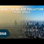
Air pollution is the largest environmental health risk in Europe and significantly impacts the health of the European population, particularly in urban areas.
Following on from the Sentinel-5P satellite – the first Copernicus mission dedicated to monitoring our atmosphere – the Sentinel-4 and Sentinel-5 missions will take current air quality measuring capabilities to the next level.
Together, the Sentinel-4 and -5 missions will provide information on atmospheric variables in support of European policies. This will include the monitoring of air quality, stratospheric ozone and solar radiation, and climate monitoring.
This video features interviews with Giorgio Bagnasco, Sentinel-4 Mission Project Manager, Ben Veilhelmann, Sentinel-4&5 Mission Scientist and Didier Martin, Sentinel-5 Mission Project Manager.
Credits: ESA – European Space Agency
★ Subscribe: http://bit.ly/ESAsubscribe and click twice on the bell button to receive our notifications.
We are Europe’s gateway to space. Our mission is to shape the development of Europe’s space capability and ensure that investment in space continues to deliver benefits to the citizens of Europe and the world. Check out https://www.esa.int/ to get up to speed on everything space related.
Climate change exacerbates droughts by making them more frequent, longer, and more severe. This can have a wide range of impacts on the environment, agriculture, ecosystems and communities including water scarcity, crop failure and food shortages.
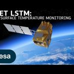
The upcoming Copernicus Land Surface Temperature Monitoring, LSTM, mission will improve sustainable agricultural productivity in a world of increasing water scarcity and variability.
The mission will carry a high spatial-temporal resolution thermal infrared sensor to provide observations of land-surface temperature.
These data are key to understand and respond to climate variability, manage water resources for agricultural production, predict droughts and also to address land degradation.
LSTM is one of six Copernicus Sentinel Expansion missions that ESA is developing on behalf of the EU. The missions will expand the current capabilities of the Copernicus Space Component – the world’s biggest supplier of Earth observation data.
This video features interviews with Ana Bolea Alamanac, LSTM Mission Project Manager, Ilias Manolis, LSTM Mission Payload Manager and Itziar Barat, LSTM Mission System and Operations Manager.
Credits: ESA – European Space Agency
★ Subscribe: http://bit.ly/ESAsubscribe and click twice on the bell button to receive our notifications.
We are Europe’s gateway to space. Our mission is to shape the development of Europe’s space capability and ensure that investment in space continues to deliver benefits to the citizens of Europe and the world. Check out https://www.esa.int/ to get up to speed on everything space related.
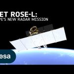
The upcoming Copernicus Radar Observation System for Europe in L-band (ROSE-L) will provide continuous day-and-night all-weather monitoring of Earth’s land, oceans and ice, and offer frequent images at a high spatial resolution.
ROSE-L will carry an active phased array synthetic aperture radar instrument. The radar antenna will be the largest planar antenna ever built measuring an impressive 40 sq m – roughly the size of 10 ping-pong tables.
ROSE-L will deliver essential information on forests and land cover, leading to improved monitoring of the terrestrial carbon cycle and carbon accounting.
The mission will also greatly extend our ability to monitor minute surface displacements and helping detect geohazards. It will automatically map surface soil moisture conditions and monitor sea and land ice – greatly helping climate change research and mitigation.
ROSE-L is one of six Copernicus Sentinel Expansion missions that ESA is developing on behalf of the EU. The missions will expand the current capabilities of the Copernicus Space Component – the world’s biggest supplier of Earth observation data.
This video features interviews with Malcolm Davidson, ROSE-L Mission Scientist, Nico Gebert, ROSE-L Payload Manager and Gianluigi Di Cosimo, ROSE-L Project Manager.
Credits: ESA – European Space Agency
★ Subscribe: http://bit.ly/ESAsubscribe and click twice on the bell button to receive our notifications.
We are Europe’s gateway to space. Our mission is to shape the development of Europe’s space capability and ensure that investment in space continues to deliver benefits to the citizens of Europe and the world. Check out https://www.esa.int/ to get up to speed on everything space related.
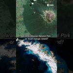
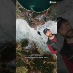
Chiara’s favourite satellite image is a rare (and almost cloud-free) view of the remote Elephant Island, in Antarctica.
This Copernicus Sentinel-2 image was captured a year ago and the full image has a 10 m resolution!
Do you agree with Chiara’s choice?
📸 Italy, South Georgia Island, Elephant Island: contains modified Copernicus Sentinel data (2016, 2018, 2023), processed by ESA, Creative Commons BY-SA 3.0 IGO.
According to the Food and Agriculture Organization (FAO), global agricultural production will need to increase by 60% by 2050 to meet the food demands of the growing global population.
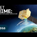
A new satellite called Copernicus Hyperspectral Imaging Mission for the Environment, or CHIME, is being developed to support EU policies on the management of natural resources – ultimately helping to address the global issue of food security.
CHIME will carry a unique visible to shortwave infrared spectrometer to provide routine hyperspectral observations to support new and enhanced services for sustainable agricultural and biodiversity management, as well as soil property characterisation.
CHIME is one of six Copernicus Sentinel Expansion missions that ESA is developing on behalf of the EU. The missions will expand the current capabilities of the Copernicus Space Component – the world’s biggest supplier of Earth observation data.
This video features interviews with Marco Celesti, CHIME Mission Scientist and Jens Nieke, CHIME Project Manager.
Credits: ESA – European Space Agency
★ Subscribe: http://bit.ly/ESAsubscribe and click twice on the bell button to receive our notifications.
We are Europe’s gateway to space. Our mission is to shape the development of Europe’s space capability and ensure that investment in space continues to deliver benefits to the citizens of Europe and the world. Check out https://www.esa.int/ to get up to speed on everything space related.
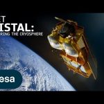
Tracking ice lost from the world’s glaciers, ice sheets and frozen land shows that Earth is losing ice at an accelerating rate. Monitoring the cryosphere is crucial for assessing, predicting and adapting to climate change.
The Copernicus Polar Ice and Snow Topography Altimeter (CRISTAL) mission will provide a full picture of the changes taking place in some of the most inhospitable regions of the world. It will carry – for the first time – a dual-frequency radar altimeter, and microwave radiometer, that will measure and monitor sea-ice thickness, overlying snow depth and ice-sheet elevations.
These data will support maritime operations in the polar oceans and contribute to a better understanding of climate processes. CRISTAL will also support applications related to coastal and inland waters, as well as providing observations of ocean topography.
CRISTAL is one of six Copernicus Sentinel Expansion missions that ESA is developing on behalf of the EU. The missions will expand the current capabilities of the Copernicus Space Component – the world’s biggest supplier of Earth observation data.
This video features interviews with Kristof Gantois, CRISTAL Project Manager and Paolo Cipollini, CRISTAL Mission Scientist.
Credits: ESA – European Space Agency
★ Subscribe: http://bit.ly/ESAsubscribe and click twice on the bell button to receive our notifications.
We are Europe’s gateway to space. Our mission is to shape the development of Europe’s space capability and ensure that investment in space continues to deliver benefits to the citizens of Europe and the world. Check out https://www.esa.int/ to get up to speed on everything space related.
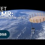
The Arctic is experiencing disproportionately higher temperature increases compared to the rest of the planet, triggering a series of cascading effects. This rapid warming has profound implications for global climate patterns, human populations and wildlife.
The Copernicus Imaging Microwave Radiometer mission (CIMR) will provide measurements to decision makers with evidence of change and impact in the polar regions – with a focus on the Arctic.
The mission has the largest radiometer developed by ESA and will provide high-resolution measurements related to sea ice, the ocean, snow and ice-sheet surfaces. This will be crucial in understanding the evolution of the climate in the polar region.
CIMR is one of six Copernicus Sentinel Expansion missions that ESA is developing on behalf of the EU. The missions will expand the current capabilities of the Copernicus Space Component – the world’s biggest supplier of Earth observation data.
This video features interviews with Craig Donlon, CIMR Mission Scientist, Rolv Midthassel, CIMR Payload Manager, Claudio Galeazzi, CIMR Project Manager, Mariel Triggianese, CIMR Satellite Engineering and AIV Manager, and Marcello Sallusti, CIMR System Performance and Operations Manager.
In the meantime Craig has changed his role but will retain his position as Mission Scientist.
Credits: ESA – European Space Agency
★ Subscribe: http://bit.ly/ESAsubscribe and click twice on the bell button to receive our notifications.
We are Europe’s gateway to space. Our mission is to shape the development of Europe’s space capability and ensure that investment in space continues to deliver benefits to the citizens of Europe and the world. Check out https://www.esa.int/ to get up to speed on everything space related.
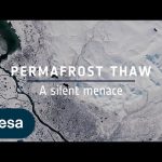
Ice is without doubt one of the first casualties of climate change, but the effects of our warming world are not only limited to ice melting on Earth’s surface. Ground that has been frozen for thousands of years, called permafrost, is thawing – adding to the climate crisis and causing serious issues for local communities.
Scientists estimate that the world’s permafrost holds almost double the amount of carbon that is currently in the atmosphere. When permafrost warms and thaws, it releases methane and carbon dioxide, adding these greenhouse gases to the atmosphere and making global warming even worse.
While permafrost cannot be directly observed from space, a lot of different types of satellite data, along with ground measurements and modelling, allow scientists to paint a picture of permafrost ground conditions.
Credits: ESA – European Space Agency
★ Subscribe: http://bit.ly/ESAsubscribe and click twice on the bell button to receive our notifications.
We are Europe’s gateway to space. Our mission is to shape the development of Europe’s space capability and ensure that investment in space continues to deliver benefits to the citizens of Europe and the world. Check out https://www.esa.int/ to get up to speed on everything space related.
The Copernicus Anthropogenic Carbon Dioxide Monitoring (CO2M) mission will be the first satellite mission to measure how much carbon dioxide is released into the atmosphere through human activity.
CO2M isn’t just a mission; it’s a crucial step in our commitment to understanding and mitigating climate change. It will offer unprecedented precision in monitoring carbon dioxide emissions from the combustion of fossil fuel at national and regional scales.
Its data will provide the EU with a unique and independent source of information to assess the effectiveness of policy measures and to track their impact towards decarbonising Europe ahead of the next Global Stocktake set to place in 2028.
The video features interviews with Valerie Fernandez, CO2M Mission Project Manager, Yannig Durand, CO2M Payload Manager and Yasjka Meijer, CO2M Mission Scientist.
We are Europe’s gateway to space. Our mission is to shape the development of Europe’s space capability and ensure that investment in space continues to deliver benefits to the citizens of Europe and the world. Check out https://www.esa.int/ to get up to speed on everything space related.
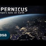
25 years ago, Copernicus set out to transform the way we see our planet. It is the largest environmental monitoring programme in the world. Learn more about the Copernicus programme and the Sentinel satellite missions developed by ESA. 👉 https://www.esa.int/Applications/Observing_the_Earth/Copernicus
Credits: ESA
★ Subscribe: http://bit.ly/ESAsubscribe and click twice on the bell button to receive our notifications.
We are Europe’s gateway to space. Our mission is to shape the development of Europe’s space capability and ensure that investment in space continues to deliver benefits to the citizens of Europe and the world. Check out https://www.esa.int/ to get up to speed on everything space related.
In the 1980s, scientists discovered a gaping hole in Earth’s ozone layer, caused by humanmade chemicals. But what is the ozone hole? Join us to find out!
We are Europe’s gateway to space. Our mission is to shape the development of Europe’s space capability and ensure that investment in space continues to deliver benefits to the citizens of Europe and the world. Check out https://www.esa.int/ to get up to speed on everything space related.
The Copernicus Data Space Ecosystem offers immediate access to a wide range of open and free Earth observation data and services. Following from the success of the current Copernicus Data Hub distribution, the new service ensures continuity and extends the portfolio for data access and data processing possibilities.
The Copernicus Data Space Ecosystem represents a significant leap forward in the way users can access and work with Earth observation data. The service aims to further improve access and exploitation of the Copernicus satellites data.
We are Europe’s gateway to space. Our mission is to shape the development of Europe’s space capability and ensure that investment in space continues to deliver benefits to the citizens of Europe and the world. Check out https://www.esa.int/ to get up to speed on everything space related.
Mecklenburg–West Pomerania is one of Germany’s least populated states. Nearly two-thirds is covered by farmland with the main crops being rye, wheat, barley and hay. The green areas present in this image are most likely winter wheat and winter rapeseed. The region’s pastures typically support sheep, horses and cattle.
On the state’s coastline on the Baltic Sea lie many holiday resorts, unspoilt nature and the islands of Rügen and Usedom, as well as many others.
We are Europe’s gateway to space. Our mission is to shape the development of Europe’s space capability and ensure that investment in space continues to deliver benefits to the citizens of Europe and the world. Check out https://www.esa.int/ to get up to speed on everything space related.
Separating the Black Sea and the Sea of Marmara, the Bosphorus strait is one of the busiest maritime passages in the world, with around 48 000 ships passing through every year. Daily traffic includes international commercial shipping vessels and oil tankers, as well as local fishing and ferries.
The two identical Copernicus Sentinel-1 satellites carry radar instruments, which can see through clouds and rain, and in the dark, to image Earth’s surface below. The multi-temporal remote sensing technique combines two or more radar images over the same area to detect changes occurring between acquisitions.
We are Europe’s gateway to space. Our mission is to shape the development of Europe’s space capability and ensure that investment in space continues to deliver benefits to the citizens of Europe and the world. Check out https://www.esa.int/ to get up to speed on everything space related.
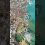
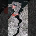
Italy has declared a state of emergency after a devastating landslide ripped through the island of Ischia on 26 November. More than 10 people have lost their lives after the landslide destroyed houses and swept cars into the sea. Satellite data shows the extent of the damage and the Copernicus Emergency Management Service has been activated to provide flood maps from space to help responders deal with the crisis.
★ Subscribe: http://bit.ly/ESAsubscribe and click twice on the bell button to receive our notifications.
We are Europe’s gateway to space. Our mission is to shape the development of Europe’s space capability and ensure that investment in space continues to deliver benefits to the citizens of Europe and the world. Check out https://www.esa.int/ to get up to speed on everything space related.
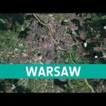
Warsaw straddles the Vistula (Wisla) River, the largest river in Poland. With a length of around 1000 km and a drainage basin of some 195 000 sq km, the Vistula is an important waterway to the nations of Eastern Europe.
We are Europe’s gateway to space. Our mission is to shape the development of Europe’s space capability and ensure that investment in space continues to deliver benefits to the citizens of Europe and the world. Check out https://www.esa.int/ to get up to speed on everything space related.
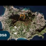
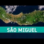
The archipelago is the largest island of the Azores autonomous region of Portugal.
The island has a region called Furnace Valley which is famous for its volcanic landscape. Local cooking methods have been influenced by their surroundings.
Cozido das Furnas is a specialty, stew type dish in the region and is prepared by lowering a pot filled with meat and vegetables into the valleys hot springs and leaving to cook for around 5 hours.
★ Subscribe: http://bit.ly/ESAsubscribe and click twice on the bell button to receive our notifications.
We are Europe’s gateway to space. Our mission is to shape the development of Europe’s space capability and ensure that investment in space continues to deliver benefits to the citizens of Europe and the world. Check out https://www.esa.int/ to get up to speed on everything space related.
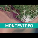
Montevideo is the southernmost capital city in the Americas and is known for its beaches – visible east of the city. The Rambla of Montevideo, the city’s famous promenade, stretches for 27 km along the coast – making it one of the longest esplanades in the world.
We are Europe’s gateway to space. Our mission is to shape the development of Europe’s space capability and ensure that investment in space continues to deliver benefits to the citizens of Europe and the world. Check out https://www.esa.int/ to get up to speed on everything space related.
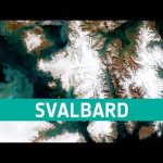
This week’s edition of the Earth from Space programme features a rare, cloud-free Copernicus Sentinel-2 acquisition over the Norwegian archipelago of Svalbard.
We are Europe’s gateway to space. Our mission is to shape the development of Europe’s space capability and ensure that investment in space continues to deliver benefits to the citizens of Europe and the world. Check out https://www.esa.int/ to get up to speed on everything space related.
Famous for its musical and artistic cultural heritage millions of tourists flock to the Venetian archipelago every year. Snaking through the central districts is the Grand Canal, with the Santa Lucia train station at its northern end and the Saint Mark Basin at its southern end.
We are Europe’s gateway to space. Our mission is to shape the development of Europe’s space capability and ensure that investment in space continues to deliver benefits to the citizens of Europe and the world. Check out https://www.esa.int/ to get up to speed on everything space related.
We are Europe’s gateway to space. Our mission is to shape the development of Europe’s space capability and ensure that investment in space continues to deliver benefits to the citizens of Europe and the world. Check out https://www.esa.int/ to get up to speed on everything space related.
The image depicts the fragmented coast, part of the Indus River Delta. A river delta forms when sediment carried from the river enters a stagnant body of water, creating an alluvial fan, which in this case extends 150 km along the coastline. The Indus River, visible on the right, veers through the Sindh Province and is one of the longest rivers in the world, rising in Tibet and flowing around 3000 km before emptying into the Arabian Sea.
We are Europe’s gateway to space. Our mission is to shape the development of Europe’s space capability and ensure that investment in space continues to deliver benefits to the citizens of Europe and the world. Check out https://www.esa.int/ to get up to speed on everything space related.
This week’s edition of the Earth from Space programme features a Copernicus Sentinel-1 radar image of the Mississippi River, one of the longest rivers in North America.
We are Europe’s gateway to space. Our mission is to shape the development of Europe’s space capability and ensure that investment in space continues to deliver benefits to the citizens of Europe and the world. Check out https://www.esa.int/ to get up to speed on everything space related.
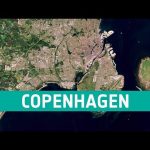
The Copenhagen-Malmö Port stretches 10 km between Zealand and Amager and 7 km along the Sound. Adjacent to the modern port facilities a star-shaped fortification, known as Kastellet, can be seen. A relic of Copenhagen’s past, this fortress is more than 340 years old.
We are Europe’s gateway to space. Our mission is to shape the development of Europe’s space capability and ensure that investment in space continues to deliver benefits to the citizens of Europe and the world. Check out https://www.esa.int/ to get up to speed on everything space related.
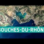
In this week’s edition of the Earth from Space programme, the Copernicus Sentinel-2 mission takes us over the department of Bouches-du-Rhône in southern France. It is from here where the first Meteosat Third Generation Imager satellite set sail on its journey to Europe’s Spaceport in French Guiana.
We are Europe’s gateway to space. Our mission is to shape the development of Europe’s space capability and ensure that investment in space continues to deliver benefits to the citizens of Europe and the world. Check out https://www.esa.int/ to get up to speed on everything space related.
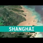
Shanghai, China is a significant global financial centre and it is also the site of one of the worlds busiest container ports because of its strategic location on the Yangtze River delta.
We are Europe’s gateway to space. Our mission is to shape the development of Europe’s space capability and ensure that investment in space continues to deliver benefits to the citizens of Europe and the world. Check out https://www.esa.int/ to get up to speed on everything space related.
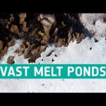
This week’s edition of the Earth from Space programme features a Copernicus Sentinel-2 image of melt ponds in the province of Avannaata in West Greenland.
We are Europe’s gateway to space. Our mission is to shape the development of Europe’s space capability and ensure that investment in space continues to deliver benefits to the citizens of Europe and the world. Check out https://www.esa.int/ to get up to speed on everything space related.
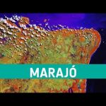
The wavelength combination used to create this image of the island of Marajó in Brazil is particularly useful for identifying different vegetation types and helps us to distinguish it very clearly from inland water bodies: water appears dark blue, while vegetation appears in a variety of bright colours.
We are Europe’s gateway to space. Our mission is to shape the development of Europe’s space capability and ensure that investment in space continues to deliver benefits to the citizens of Europe and the world. Check out https://www.esa.int/ to get up to speed on everything space related.
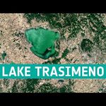
In this week’s edition of the Earth from Space programme, the Copernicus Sentinel-2 mission takes us over Lake Trasimeno, the fourth largest lake in Italy.
We are Europe’s gateway to space. Our mission is to shape the development of Europe’s space capability and ensure that investment in space continues to deliver benefits to the citizens of Europe and the world. Check out https://www.esa.int/ to get up to speed on everything space related.
We are Europe’s gateway to space. Our mission is to shape the development of Europe’s space capability and ensure that investment in space continues to deliver benefits to the citizens of Europe and the world. Check out https://www.esa.int/ to get up to speed on everything space related.
This week’s edition of the Earth from Space programme features a Copernicus Sentinel-3 image showing the scale of Britain’s heatwave as it baked in extreme temperatures in August.
We are Europe’s gateway to space. Our mission is to shape the development of Europe’s space capability and ensure that investment in space continues to deliver benefits to the citizens of Europe and the world. Check out https://www.esa.int/ to get up to speed on everything space related.
We are Europe’s gateway to space. Our mission is to shape the development of Europe’s space capability and ensure that investment in space continues to deliver benefits to the citizens of Europe and the world. Check out https://www.esa.int/ to get up to speed on everything space related.
We are Europe’s gateway to space. Our mission is to shape the development of Europe’s space capability and ensure that investment in space continues to deliver benefits to the citizens of Europe and the world. Check out https://www.esa.int/ to get up to speed on everything space related.
We are Europe’s gateway to space. Our mission is to shape the development of Europe’s space capability and ensure that investment in space continues to deliver benefits to the citizens of Europe and the world. Check out https://www.esa.int/ to get up to speed on everything space related.
We are Europe’s gateway to space. Our mission is to shape the development of Europe’s space capability and ensure that investment in space continues to deliver benefits to the citizens of Europe and the world. Check out https://www.esa.int/ to get up to speed on everything space related.
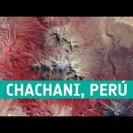
Chachani is the tallest of the mountains near the Peruvian city of Arequipa. The outskirts of the city and part of the airport runway are just visible in the centre bottom of the image.
We are Europe’s gateway to space. Our mission is to shape the development of Europe’s space capability and ensure that investment in space continues to deliver benefits to the citizens of Europe and the world. Check out https://www.esa.int/ to get up to speed on everything space related.
We are Europe’s gateway to space. Our mission is to shape the development of Europe’s space capability and ensure that investment in space continues to deliver benefits to the citizens of Europe and the world. Check out https://www.esa.int/ to get up to speed on everything space related.