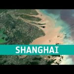
Shanghai, China is a significant global financial centre and it is also the site of one of the worlds busiest container ports because of its strategic location on the Yangtze River delta.
We are Europe’s gateway to space. Our mission is to shape the development of Europe’s space capability and ensure that investment in space continues to deliver benefits to the citizens of Europe and the world. Check out https://www.esa.int/ to get up to speed on everything space related.
The series of heatwaves we are currently experiencing in western Europe is a clear sign of human-induced global warming. ESA’s Clement Albergel explains how we monitor these events using satellites such as the Copernicus Sentinel-3 mission and puts them in the context of the long-term climate data record generated via ESA’s Climate Change Initiative.
Credits: ESA
★ Subscribe: http://bit.ly/ESAsubscribe and click twice on the bell button to receive our notifications.
We are Europe’s gateway to space. Our mission is to shape the development of Europe’s space capability and ensure that investment in space continues to deliver benefits to the citizens of Europe and the world. Check out https://www.esa.int/ to get up to speed on everything space related.
We are Europe’s gateway to space. Our mission is to shape the development of Europe’s space capability and ensure that investment in space continues to deliver benefits to the citizens of Europe and the world. Check out https://www.esa.int/ to get up to speed on everything space related.
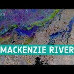
In this week’s edition of the Earth from Space programme, the Copernicus Sentinel-1 mission takes us over the Mackenzie River, a major river system in the Canadian boreal forest.
We are Europe’s gateway to space. Our mission is to shape the development of Europe’s space capability and ensure that investment in space continues to deliver benefits to the citizens of Europe and the world. Check out https://www.esa.int/ to get up to speed on everything space related.
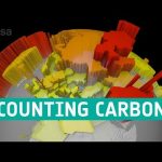
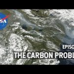
The Paris Agreement adopted a target for global warming not to exceed 1.5°C. This sets a limit on the additional carbon we can add to the atmosphere – the carbon budget. Only 18% of the carbon budget is now left. That is about 10 years at current emission rates.
Each country reports its annual greenhouse gas emissions to the United Nations. Scientists then set these emissions against estimates of the carbon absorbed by Earth’s natural carbon sinks. This is known as the bottom-up approach to calculating the carbon budget.
Another way to track carbon sources and sinks is to measure the amounts of greenhouse gases in the atmosphere from space – the top-down approach. As well as tracking atmospheric carbon, ESA’s Climate Change Initiative is using satellite observations to track other carbon stocks on land and sea.
How we use the land accounts for about a quarter of our greenhouse gas emissions. Forests are the largest store of carbon on the land. Fire acts as a conduit for carbon to pass from the land to the atmosphere. And phytoplankton in the ocean is an important carbon sink.
ESA’s RECCAP-2 project is using this information to reconcile the differences between the bottom-up and top-down approaches. Observations are combined with atmospheric and biophysical computer models to deduce carbon fluxes at the surface. This will improve the precision of each greenhouse gas budget and help separate natural fluxes from agricultural and fossil fuel emissions. This work will help us gauge whether we can stay within the 1.5°C carbon budget, or if more warming is in store.
Credits: ESA/Planetary Visions
★ Subscribe: http://bit.ly/ESAsubscribe and click twice on the bell button to receive our notifications.
We are Europe’s gateway to space. Our mission is to shape the development of Europe’s space capability and ensure that investment in space continues to deliver benefits to the citizens of Europe and the world. Check out https://www.esa.int/ to get up to speed on everything space related.
In the Arctic, fires are a natural part of the ecosystem. But as the climate changes, fires are burning longer and hotter, releasing long-buried carbon from the soil. #NASAExplorers are looking from high in the sky to deep below the ground to better understand how a warming climate affects fires in the Arctic…and how fires in the region will contribute to climate change in the future. #S3E3
Chasing smoke is a round-the-clock business. Wildfire smoke can travel long distances and over several days, so #NASAExplorers with the Fire Influence on Regional to Global Environments and Air Quality (FIREX-AQ) mission took to the field to find where it goes. From a plane directly above the Shady Fire in the middle of the afternoon to a valley in the Sawtooth Mountains at 1 in the morning, explorers are gathering important data about how fire smoke affects communities near and far. #S3E2
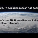
NASA has a unique and important view of hurricanes around the planet. Satellites and aircraft watch as storms form, travel across the ocean and sometimes, make landfall. After the hurricanes have passed, the satellites and aircraft see the aftermath of hurricanes, from downed forests to mass power loss. Complete transcript available.
Music credit: “Northern Breeze” by Denis Levaillant [SACEM], “Stunning Horizon” by Maxime Lebidois [SACEM], Ronan Maillard [SACEM], “Magnetic Force” by JC Lemay [SACEM] from Killer Tracks
This video is public domain and along with other supporting visualizations can be downloaded from the Scientific Visualization Studio at: http://svs.gsfc.nasa.gov/13216
Of all the planets NASA has explored, none have matched the dynamic complexity of our own. Earth is a very special place. From the vantage point of space, the perspective of sky and sea, and all across the land, we study our planet not only to learn about it, but also to protect it.
NASA is everywhere – our space technology turns up in nearly all corners of modern life. The world has come to rely on GPS signal correction software created by NASA, which enables precision agriculture, airplane navigation, smartphones, Earth science and much more. A lightweight, high-pressure tank NASA invented to hold rocket fuel now stores life-saving oxygen to keep pilots, firefighters and intensive care patients breathing — not to mention gases that power city buses and even paintball guns. Fitness enthusiasts may be surprised to learn about NASA’s contribution to the Bowflex Revolution resistance-exercise home gym.
In the pre-dawn hours of a late October day, a satellite and an airplane joined forces over the frigid Weddell Sea, taking simultaneous measurements of drifting sea ice. It was the culmination of more than a decade of planning, designing and building the best way to measure Earth’s changing ice.
#NASAExplorers are constantly pushing the limit to learn more about our world and those far beyond. Join in as they celebrate a milestone in the quest to better understand the planet we call home.
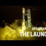
It’s 5 a.m. on a normal September day and #NASAExplorers have gathered in a California field to watch a rocket launch light up the pre-dawn sky. On board the rocket is a satellite more than 10 years in the making, with one single instrument that will revolutionize the study of ice on Earth. Join the team in the excitement and stress of watching ICESat-2 launch into space and begin its work measuring our home planet.
This week, #NASAExplorers head back in time…by going underground. In the Arctic, a frozen layer of soil – permafrost – trapped dead plants and animals for thousands of years. As the climate warms, that soil is beginning to thaw, releasing carbon dioxide and methane.
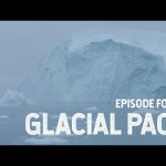
#NASAExplorers study Earth’s glaciers and ice sheets more than almost any other part of the cryosphere. As they melt and change, glaciers and ice sheets dramatically affect sea level rise and the climate system as a whole, creating an urgency to understand and forecast their behavior.
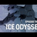
To know the evolution of sea ice and how we observe it from space is to know Dr. Claire Parkinson. Meet the scientist who continues to have a profound effect on the study of climate change through her work monitoring the health of global sea ice.
Snow is one part of the cryosphere that many of us have actually encountered, but it also plays a crucial role in regulating Earth’s climate. Through decades of remote sensing, NASA has kept a close eye on the ebb and flow of snow cover. #NASAExplorers also venture into the field at the far reaches of Earth to study snow, a critical resource for the millions of people who rely on it for drinking water.
NASA Explorers is a new digital series that takes you inside the space agency and follows the pioneers, risk-takers and experts at the front line of exploration. Season 1, “Cryosphere,” joins NASA scientists on their journey to the frozen ends of the Earth as they study our rapidly changing world from satellites, planes and boots on the ground. The Cryosphere is a place we all depend on, but many of us will never go to. As temperatures rise, the frozen regions of Earth are changing rapidly. NASA scientists are locked in a race against time to understand our shifting climate and how it affects life on Earth.
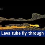
The “Cueva de los Verdes” lava tube in Lanzarote, Spain, is one of the world’s largest volcanic cave complexes with a total length of about 8 km.
Geology experts from ESA’s Pangaea-X campaign mapped most of the lava tube system as part of a project supported by local authorities Cabildo of Lanzarote and the University of Padova, Italy. The data was acquired in November 2017 by Leica Geosystems.
The map comes alive in great detail in 3D, helping institutions to protect the subterranean environment. The map also provides scientific data to study the origins of the tube and its peculiar formations.
Pangaea-X is a test campaign that brings together geology, high-tech survey equipment and space exploration. Learn more about the science and technology behind this campaign visiting http://blogs.esa.int/pangaea
ESA’s Earth Explorer Aeolus satellite will be launched later this year to measure the world’s winds from space. The satellite carries one of the most sophisticated instruments ever to be put into orbit: Aladin, which includes two powerful lasers, a large telescope and very sensitive receivers. The laser generates ultraviolet light that is beamed down into the atmosphere to profile the world’s winds – a completely new approach to measuring the wind from space. These vertical slices through the atmosphere, along with information it gathers on aerosols and clouds, will improve our understanding of atmospheric dynamics and contribute to climate research. As well as advancing science, Aeolus will play an important role in improving weather forecasts. The mission will also complement information about the atmosphere being provided by the Copernicus Sentinel missions.
NASA researchers are presenting new findings on a wide range of Earth and space science topics at the annual meeting of the American Geophysical Union this week in San Francisco. With about 24,000 attendees, the meeting is the largest gathering of Earth and space scientists in the world. The full range of NASA’s innovative science and technology is on display. Key findings include new evidence from NASA’s Curiosity rover of how ancient lakes and wet underground environments on Mars changed billions of years ago affecting their favorability for microbial life. A new Earth-observing satellite data set and imagery was released providing a near-real-time view of every large glacier and ice sheet on Earth. The meeting continues through Dec. 16.
Kasha Patel and Mike Behrenfeld chat about the North Atlantic Aerosols and Marine Ecosystems Study (NAAMES). This NASA field experiment took to the sea in May to investigate the world’s largest plankton bloom and how it gives rise to small organic particles that leave the ocean and end up in the atmosphere, ultimately influencing clouds and climate.
NASA’s first oceanographic research expedition left Alaska on June 15, 2010. The five-week ICESCAPE mission is headed into the Arctic to study sea ice and the changing ocean ecosystem. Listen to the scientists as they get ready to head to sea.