It can be seen as a dark blob passing through to the lower left.
Phobos sits very close to Mars by Solar System standards, orbiting just 6000 km from Mars’s surface. For context, our own moon lies about 385 000 km away from Earth’s surface.
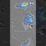
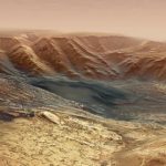
Our Mars Express has revisited one of Mars’s most intriguing features the Medusae Fossae, revealing what seems to be layers of water ice below the dusty surface.
If melted, this potential water would be enough to fill Earth’s Red Sea, or cover Mars in a layer of water up to 2.7 m deep!
📸 Planetary Science Institute/Smithsonian Institution 📸 European Space Agency / DLR / FU Berlin 📸 CReSIS/KU/Smithsonian Institution
We are Europe’s gateway to space. Our mission is to shape the development of Europe’s space capability and ensure that investment in space continues to deliver benefits to the citizens of Europe and the world. Check out https://www.esa.int/ to get up to speed on everything space related.
This video shows Jezero crater, the landing site of the @NASA Mars 2020 Perseverance rover on the Red Planet, based on images from ESA’s Mars Express mission. The planned landing area is marked with an orange ellipse.
Scheduled for launch from Cape Canaveral, Florida on 30 July 2020 on board an Atlas V rocket, the Perseverance rover will land on 18 February 2021 in Jezero crater.
An impact crater with a diameter of about 45 km, Jezero is located at the rim of the giant Isidis impact basin. Morphological evidence suggests that the crater once hosted a lake, some 3.5 billion years ago.
Jezero possesses an inlet- and an outlet channel. The inlet channel discharges into a fan-delta deposit, containing water-rich minerals such as smectite clays. Scientists believe that the lake was relatively long lived because the delta may have required 1 to 10 million years to reach its thickness and size. Other studies conclude that the lake did not experience periods of important water-level fluctuations and that it was formed by a continuous surface runoff. This makes Jezero crater to a prime target for the search for potential signs of microbial life, because organic molecules are very well preserved in river deltas and lake sediments.
The animation was created using an image mosaic made from four single orbit observations obtained by the High Resolution Stereo Camera (HRSC) on Mars Express between 2004 and 2008. The mosaic combines data from the HRSC nadir and colour channels; the nadir channel is aligned perpendicular to the surface of Mars, as if looking straight down at the surface. The mosaic image was then combined with topography information from the stereo channels of HRSC to generate a three-dimensional landscape, which was then recorded from different perspectives, as with a movie camera, to render the flight shown in the video.
Copyright:
Animation: ESA/DLR/FU Berlin, CC BY-SA 3.0 IGO
Music: Björn Schreiner
Soundtrack logo: Alicia Neesemann
★ Subscribe: http://bit.ly/ESAsubscribe and click twice on the bell button to receive our notifications.
We are Europe’s gateway to space. Our mission is to shape the development of Europe’s space capability and ensure that investment in space continues to deliver benefits to the citizens of Europe and the world. Check out http://www.esa.int/ESA to get up to speed on everything space related.
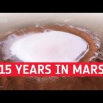
On 25 December 2003, ESA’s Mars Express entered orbit around the Red Planet. The spacecraft began returning the first images from orbit using its High Resolution Stereo Camera just a couple of weeks later, and over the course of its fifteen year history has captured thousands of images covering the globe.
This video compilation highlights some of the stunning scenes revealed by this long-lived mission. From breathtaking horizon-to-horizon views to the close-up details of ice- and dune-filled craters, and from the polar ice caps and water-carved valleys to ancient volcanoes and plunging canyons, Mars Express has traced billions of years of geological history and evolution.
ESA is Europe’s gateway to space. Our mission is to shape the development of Europe’s space capability and ensure that investment in space continues to deliver benefits to the citizens of Europe and the world. Check out http://www.esa.int/ESA to get up to speed on everything space related.
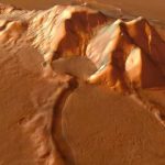
This movie, based on images taken by ESA’s Mars Express, showcases the 102 km wide Neukum Crater in the southern hemisphere of Mars.
The crater is named for the German physicist and planetary scientist, Gerhard Neukum, one of the founders of ESA’s Mars Express mission who inspired and led the development of the high-resolution stereo camera on Mars Express.
This complex impact crater has a diverse geologic history, as indicated by various features on the crater rim and floor. Particularly striking are the dark dune fields, likely made up of volcanic material blown in and shaped by strong winds.
The crater’s shallow interior has been infilled by sediments over its history. It is also marked with two irregular depressions that may be a sign of a weaker material that has since eroded away, leaving behind some islands of more resistant material.
Over time the crater rim has undergone varying degrees of collapse, with landslides and slumped material visible in the crater walls. Many smaller craters have also overprinted the rim and pockmarked the interior since Neukum Crater was formed, highlighting its long history.
Neukum Crater is situated in Noachis Terra, one of the oldest known regions on Mars, dating back to at least 3.9 billion years.
Credits: Animation: ESA/DLR/FU Berlin, CC BY-SA 3.0 IGO; Music: Coldnoise, CC BY-SA 4.0 and Adrian Neesemann
These observations of Phobos and Saturn were taken by the Super Resolution Channel of the High Resolution Stereo Camera on Mars Express. The video comprises 30 separate images acquired during Mars Express orbit 16 346 on 26 November 2016. The slight up and down movement of Saturn and Phobos in these images is caused by the oscillation of the spacecraft’s orientation after completing the turn towards the moon. Phobos can be seen in the foreground, partially illuminated, with Saturn visible as a small ringed dot in the distance. For more information go tohttp://www.esa.int/Our_Activities/Space_Science/Mars_Express/Mars_Express_views_moons_set_against_Saturn_s_rings
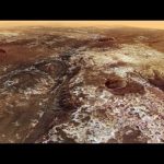
This movie, based on images taken by ESA’s Mars Express, highlights Mawrth Vallis, a 600 km-long, 2 km-deep outflow channel at the boundary of the southern highlands and the northern lowlands of Mars.
The movie begins at the mouth of the channel in Chryse Planitia, and heads towards the apparent source region in the Arabia Terra highlands.
The 4 billion year-old plateau is characterised by many impact craters, indicative of its great age.
Zooming in, patches of light and dark deposits are revealed. The light-toned layered sediments are among the largest outcrops of clay minerals – phyllosilicates – on Mars. Their presence indicates the presence of liquid water in the past.
The variety of water-bearing minerals and the possibility that they might contain a record of an ancient, habitable environment on Mars led scientists to propose Mawrth Vallis as a candidate landing site for the ExoMars 2020 mission.
The animation is based on a colour mosaic and digital terrain model derived from data collected by the high-resolution stereo camera on Mars Express and released earlier this year.
How did it all begin? What are the origins of our planet? To understand our place in the Universe we need to explore space. Find out how we’re doing this with ESA’s incredible fleet of space science missions to study our Sun and chart the stars around us, probe the dark matter and dark energy of the Universe, and tour various planets, moons and other small bodies in our Solar System.
The scene spans 987 km in the north–south direction, 19–36°N, and 1550 km in the east–west direction (280–310°E). It covers 1.55 million square kilometres, an area equivalent to the size of Mongolia.
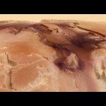
Kasei Valles is one of the largest outflow channel systems on Mars, created during dramatic flood events. From source to sink, it extends some 3000 km and descends 3 km.
Kasei Valles splits into two main branches that hug a broad island of fractured terrain — Sacra Mensa — rising 2 km above the channels that swerve around it. While weaker materials succumbed to the erosive power of the fast-flowing water, this hardier outcrop has stood the test of time.
Slightly further downstream, the flood waters did their best to erase the 100 km-wide Sharonov crater, crumpling its walls to the south. Around Sharonov many small streamlined islands form teardrop shapes rising from the riverbed as water swept around these natural obstacles.
The Planetary Science and Remote Sensing Group at Freie Universität Berlin produced the movie. The processing of the High Resolution Stereo Camera image data was carried out at the DLR German Aerospace Center.
Credit: ESA/DLR/FU Berlin (G. Neukum) / Music: Crabtambour
Fly-through movie of Hebes Chasma, the northernmost part of Valles Marineris. The movie was created from images taken by the High Resolution Stereo Camera on Mars Express.
In celebration of the 10th anniversary of Mars Express: a new and enhanced Full Orbit Video generated by multiple images acquired by the VMC camera – the Mars Webcam – on board ESA’s Mars Express
This version is a special ‘MEX birthday preview’. We’ll post a somewhat extended version late next week, to coincide with the next expected VMC image set arriving from Mars (for news, follow the VMC blog http://blogs.esa.int/vmc)
Thanks to the Mars Express Science & operations teams for generating a fabulous, unique-in-our-Solar-System view of the Red planet. And happy Birthday, Mars Express!
Credit: ESA – European Space Agency, CC BY-SA 3.0 IGO
Copyright Notice:
This work is licenced under the Creative Commons Attribution-ShareAlike 3.0 IGO (CC BY-SA 3.0 IGO) licence. The user is allowed to reproduce, distribute, adapt, translate and publicly perform this publication, without explicit permission, provided that the content is accompanied by an acknowledgement that the source is credited as ‘ESA/DLR/FU Berlin’, a direct link to the licence text is provided and that it is clearly indicated if changes were made to the original content. Adaptation/translation/derivatives must be distributed under the same licence terms as this publication. To view a copy of this license, please visit http://creativecommons.org/licenses/by-sa/3.0/igo/
The journey of Mars Express, from drawing board through launch, to its key science highlights during ten years of operations. With its suite of seven instruments, Mars Express has studied the subsurface of the Red Planet to the upper atmosphere and beyond to the two tiny moons Phobos and Deimos, providing an in depth analysis of the planet’s history and returning stunning 3D images.
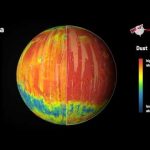
This unique atlas comprises a series of maps showing the distribution and abundance of minerals formed in water, by volcanic activity, and by weathering to create the dust that makes Mars red. Together the maps provide a global context for the dominant geological processes that have defined the planet’s history.
The maps were built from ten years of data collected by the OMEGA visible and infrared mineralogical mapping spectrometer on Mars Express.
The animation cycles through maps showing: individual sites where a range of minerals that can only be formed in the presence of water were detected; maps of olivine and pyroxene, minerals that tell the story of volcanism and the evolution of the planet’s interior; and ferric oxide and dust. Ferric oxide is a mineral phase of iron, and is present everywhere on the planet: within the bulk crust, lava outflows and the dust oxidised by chemical reactions with the martian atmosphere, causing the surface to ‘rust’ slowly over billions of years, giving Mars its distinctive red hue.
The map showing hydrated minerals includes detections made by both ESA’s Mars Express and by NASA’s Mars Reconnaissance Orbiter.