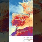
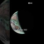
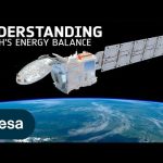
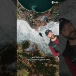
Satellites like Copernicus Sentinel-3 measure land surface temperature — that’s the heat coming directly from the ground, not the air above it. And yes, it’s often hotter in the summer than what your app tells you.
📹 European Space Agency (ESA) 📸 Contains modified Copernicus Sentinel data (2025), processed by ESA
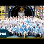
After an extraordinary six-week voyage from northern Norway, the iconic Norwegian tall ship Statsraad Lehmkuhl has docked in Nice, France, concluding ESA’s 2025 Advanced Ocean Training Course. Braving everything from wild storms to calm seas, students aboard mastered techniques for collecting ocean measurements and harnessed satellite data to unlock insights into our blue planet. Led by experts, this real-world expedition offered more than education – it sparked curiosity and a deeper commitment to understanding and protecting our oceans.
We are Europe’s gateway to space. Our mission is to shape the development of Europe’s space capability and ensure that investment in space continues to deliver benefits to the citizens of Europe and the world. Check out https://www.esa.int/ to get up to speed on everything space related.
ESA’s state-of-the-art Biomass mission is designed to provide new insights into the health and evolution of the world’s forests, helping us understand how they are changing over time and, importantly, their critical role in the global carbon cycle. Equipped with the first-ever fully polarimetric P-band synthetic aperture radar, this satellite can penetrate dense forest canopies. The long 70 cm wavelength of the radar enables it to measure ‘biomass’—the woody trunks, branches and stems—where trees store the majority of their carbon.
Credits: European Space Agency (ESA)
★ Subscribe: http://bit.ly/ESAsubscribe and click twice on the bell button to receive our notifications.
We are Europe’s gateway to space. Our mission is to shape the development of Europe’s space capability and ensure that investment in space continues to deliver benefits to the citizens of Europe and the world. Check out https://www.esa.int/ to get up to speed on everything space related.
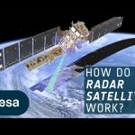
Radar allows us to see through what would otherwise be invisible. By sending out radio waves that bounce off objects and return as echoes, radar creates a detailed picture of our surrounding world.
This technology is everywhere: from guiding air traffic and enabling self-driving cars to tracking the movements of athletes. But its reach doesn’t stop there—radar is also transforming how we observe our Earth from space.
Satellites like the Copernicus Sentinel-1 mission use radar to see through clouds, darkness and any weather conditions. This capability is invaluable for detecting subtle changes on Earth’s surface—changes that are often hidden from the human eye. Discover how radar technology is helping us unlock these hidden insights about our planet.
Credit: ESA – European Space Agency
★ Subscribe: http://bit.ly/ESAsubscribe and click twice on the bell button to receive our notifications.
We are Europe’s gateway to space. Our mission is to shape the development of Europe’s space capability and ensure that investment in space continues to deliver benefits to the citizens of Europe and the world. Check out https://www.esa.int/ to get up to speed on everything space related.
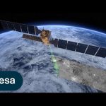
Meet Copernicus Sentinel-1 – this ground-breaking mission delivers continuous, all-weather, day-and-night imaging for land, ice and maritime monitoring.
Equipped with state-of-the-art C-band synthetic aperture radar (SAR), Sentinel-1 captures high-resolution data around the clock, in any weather, making it indispensable for detecting the subtle changes on Earth’s surface that remain hidden from the human eye.
Sentinel-1 data serves a multitude of critical applications: from ensuring the safety and efficiency of maritime traffic, tracking sea ice and icebergs, to monitoring structural integrity and natural hazards, such as earthquakes, landslides and volcanic activity.
Its enhanced radar technology provides precises precise information on ground movement, which is critical for urban planning, infrastructure resilience, subsidence risk assessment and geohazard monitoring.
Through consistent, long-term data collection, Sentinel-1 serves as a global asset, essential for environmental and safety monitoring worldwide. The mission is a beacon of innovation, advancing our understanding of our planet’s dynamic landscape.
This video features interviews with Mark Drinkwater, Head of Mission Sciences Division at ESA, Ramon Torres Cuesta, Sentinel-1 Project Manager at ESA and Julia Kubanek, Sentinel-1 Mission Scientist at ESA.
Credit: ESA – European Space Agency
★ Subscribe: http://bit.ly/ESAsubscribe and click twice on the bell button to receive our notifications.
We are Europe’s gateway to space. Our mission is to shape the development of Europe’s space capability and ensure that investment in space continues to deliver benefits to the citizens of Europe and the world. Check out https://www.esa.int/ to get up to speed on everything space related.
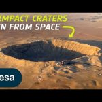
Have you ever wondered what an impact crater looks like from space? Today, we’re counting down some of our favourite impact craters here on Earth – captured by Earth-observing satellites.
Craters are inevitably part of being a rocky planet. They occur on every planetary body in our solar system – no matter the size. By studying impact craters and the meteorites that cause them, we can learn more about the processes and geology that shape our entire solar system.
We are Europe’s gateway to space. Our mission is to shape the development of Europe’s space capability and ensure that investment in space continues to deliver benefits to the citizens of Europe and the world. Check out https://www.esa.int/ to get up to speed on everything space related.
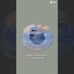
The summer solstice, which is when the Sun reaches the most northerly point in the sky, occurred on Friday 21st June at 22:50 CEST.
This is when the Northern Hemisphere will experience the longest day of the year and the Southern Hemisphere will experience the shortest.
This is because of Earth’s position in orbit around the Sun and the way the North Pole is tilted towards the Sun during the solstice.
This animation shows one image per day captured by the Meteosat Second Generation from 20 June 2023 until 19 June 2024 captured at approximately 17:30 CEST. You can see how the terminator line moved in the past year – tonight, that line will be at its greatest angle with respect to the axis of the Earth.
Do you live in the Northern or Southern Hemisphere?
ESA’s EarthCARE mission is ready for lift-off! EarthCARE is a groundbreaking satellite mission designed to unravel the mysteries of Earth’s clouds and aerosols. EarthCARE will shed light on the role that clouds and aerosols play in heating and cooling Earth’s atmosphere – contributing to our better understanding of climate change. During our live coverage, we’ll hear from mission scientists and spacecraft operators, then follow the launch on a SpaceX Falcon 9 from California, expected at 00:20 CEST. Live from ESA’s spacecraft operations centre in Germany, we take you into the main control room around 01:12 CEST for the satellite’s acquisition of signal – EarthCARE’s first sign of life from space.
Credits: ESA/SpaceX
Timestaps of the video: 00:00 – 38:24 – Start of ESA WebTV Programme – Live from the European Space Operations Centre 38:25 – 50:44 – SpaceX live broadcast begins 50:45 – 1:01:40 – Lift-off 1:01:41 – 1:06:35 – Spacecraft deployment 1:06:36 – 1:40:40 – Stay tuned 1:40:41 – 1:44:50 – ESA WebTV Programme – Live from the European Space Operations Centre 1:44:51 – 1:55:00 – Acquisition of signal
★ Subscribe: http://bit.ly/ESAsubscribe and click twice on the bell button to receive our notifications.
We are Europe’s gateway to space. Our mission is to shape the development of Europe’s space capability and ensure that investment in space continues to deliver benefits to the citizens of Europe and the world. Check out https://www.esa.int/ to get up to speed on everything space related.
As we approach the launch of ESA’s EarthCARE mission, we caught up with some of the scientists, engineers and experts behind the mission.
With the climate crisis increasingly tightening its grip, ESA’s Earth Cloud Aerosol and Radiation Explorer mission (EarthCARE) will shed new light on the complex interactions between clouds, aerosols and radiation in Earth’s atmosphere.
EarthCARE is the largest and most complex Earth Explorer mission. It comes at a critical time in the development of kilometre-scale resolution, global climate models and will provide an important contribution to an improved understanding of cloud convection and its role in Earth’s radiation budget.
EarthCARE is an ESA mission, but it has been developed as a cooperation between ESA and JAXA, the Japanese Space Agency.
This video features interviews with: Pavlos Kollias from Stony Brook University – McGill University, Thorsten Fehr, EarthCARE Mission Scientist at ESA, Robin Hogan, Senior Scientist at ECMWF, Dirk Bernaerts, EarthCARE Project Manager at ESA, Kotska Wallace, Mission and Optical Payload Manager at ESA, Tomomi Nio, EarthCARE Mission Manager at JAXA, Eiichi Tomita, EarthCARE/CPR Project Manager at JAXA, Ulla Wandinger, Senior Scientist at Leibniz Institute for Tropospheric Research and Bjoern Frommknecht, EarthCARE Mission Manager at ESA.
Follow the EarthCARE launch campaign blog for more updates.
Credits: ESA – European Space Agency
★ Subscribe: http://bit.ly/ESAsubscribe and click twice on the bell button to receive our notifications.
We are Europe’s gateway to space. Our mission is to shape the development of Europe’s space capability and ensure that investment in space continues to deliver benefits to the citizens of Europe and the world. Check out https://www.esa.int/ to get up to speed on everything space related.
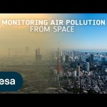
Air pollution is the largest environmental health risk in Europe and significantly impacts the health of the European population, particularly in urban areas.
Following on from the Sentinel-5P satellite – the first Copernicus mission dedicated to monitoring our atmosphere – the Sentinel-4 and Sentinel-5 missions will take current air quality measuring capabilities to the next level.
Together, the Sentinel-4 and -5 missions will provide information on atmospheric variables in support of European policies. This will include the monitoring of air quality, stratospheric ozone and solar radiation, and climate monitoring.
This video features interviews with Giorgio Bagnasco, Sentinel-4 Mission Project Manager, Ben Veilhelmann, Sentinel-4&5 Mission Scientist and Didier Martin, Sentinel-5 Mission Project Manager.
Credits: ESA – European Space Agency
★ Subscribe: http://bit.ly/ESAsubscribe and click twice on the bell button to receive our notifications.
We are Europe’s gateway to space. Our mission is to shape the development of Europe’s space capability and ensure that investment in space continues to deliver benefits to the citizens of Europe and the world. Check out https://www.esa.int/ to get up to speed on everything space related.
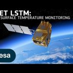
Climate change exacerbates droughts by making them more frequent, longer, and more severe. This can have a wide range of impacts on the environment, agriculture, ecosystems and communities including water scarcity, crop failure and food shortages.
The upcoming Copernicus Land Surface Temperature Monitoring, LSTM, mission will improve sustainable agricultural productivity in a world of increasing water scarcity and variability.
The mission will carry a high spatial-temporal resolution thermal infrared sensor to provide observations of land-surface temperature.
These data are key to understand and respond to climate variability, manage water resources for agricultural production, predict droughts and also to address land degradation.
LSTM is one of six Copernicus Sentinel Expansion missions that ESA is developing on behalf of the EU. The missions will expand the current capabilities of the Copernicus Space Component – the world’s biggest supplier of Earth observation data.
This video features interviews with Ana Bolea Alamanac, LSTM Mission Project Manager, Ilias Manolis, LSTM Mission Payload Manager and Itziar Barat, LSTM Mission System and Operations Manager.
Credits: ESA – European Space Agency
★ Subscribe: http://bit.ly/ESAsubscribe and click twice on the bell button to receive our notifications.
We are Europe’s gateway to space. Our mission is to shape the development of Europe’s space capability and ensure that investment in space continues to deliver benefits to the citizens of Europe and the world. Check out https://www.esa.int/ to get up to speed on everything space related.
After years of development and a rigorous testing programme, ESA’s EarthCARE satellite has left Munich, Germany, and is now on its away to SpaceX’s launch site in Vandenberg, California. Once it arrives, it will be put into storage for a few weeks until it is time to ready the satellite for liftoff – which is scheduled to launch in May on a Falcon 9 rocket.
The Earth Cloud Aerosol and Radiation Explorer, or EarthCARE for short, is the most complex Earth Explorer mission to date. The new satellite will look at the role that clouds and aerosols play in heating and cooling Earth’s atmosphere – contributing to our understanding of climate change.
With its unique set of four instruments, EarthCARE will examine the role clouds and aerosols play in reflecting solar radiation back into space and also in trapping infrared radiation emitted from Earth’s surface.
EarthCARE is a joint venture between ESA and JAXA, the Japan Aerospace Exploration Agency.
This video features interviews with Simonetta Cheli, Director of Earth Observation Programmes at ESA, Thorsten Fehr, ESA’s EarthCARE Mission Scientist, Dirk Bernaerts, ESA’s EarthCARE Project Manager and Eiichi Tomita, JAXA’s EarthCARE/CPR Project Manager.
Credits: ESA – European Space Agency
★ Subscribe: http://bit.ly/ESAsubscribe and click twice on the bell button to receive our notifications.
We are Europe’s gateway to space. Our mission is to shape the development of Europe’s space capability and ensure that investment in space continues to deliver benefits to the citizens of Europe and the world. Check out https://www.esa.int/ to get up to speed on everything space related.
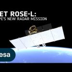
The upcoming Copernicus Radar Observation System for Europe in L-band (ROSE-L) will provide continuous day-and-night all-weather monitoring of Earth’s land, oceans and ice, and offer frequent images at a high spatial resolution.
ROSE-L will carry an active phased array synthetic aperture radar instrument. The radar antenna will be the largest planar antenna ever built measuring an impressive 40 sq m – roughly the size of 10 ping-pong tables.
ROSE-L will deliver essential information on forests and land cover, leading to improved monitoring of the terrestrial carbon cycle and carbon accounting.
The mission will also greatly extend our ability to monitor minute surface displacements and helping detect geohazards. It will automatically map surface soil moisture conditions and monitor sea and land ice – greatly helping climate change research and mitigation.
ROSE-L is one of six Copernicus Sentinel Expansion missions that ESA is developing on behalf of the EU. The missions will expand the current capabilities of the Copernicus Space Component – the world’s biggest supplier of Earth observation data.
This video features interviews with Malcolm Davidson, ROSE-L Mission Scientist, Nico Gebert, ROSE-L Payload Manager and Gianluigi Di Cosimo, ROSE-L Project Manager.
Credits: ESA – European Space Agency
★ Subscribe: http://bit.ly/ESAsubscribe and click twice on the bell button to receive our notifications.
We are Europe’s gateway to space. Our mission is to shape the development of Europe’s space capability and ensure that investment in space continues to deliver benefits to the citizens of Europe and the world. Check out https://www.esa.int/ to get up to speed on everything space related.
Chiara’s favourite satellite image is a rare (and almost cloud-free) view of the remote Elephant Island, in Antarctica.
This Copernicus Sentinel-2 image was captured a year ago and the full image has a 10 m resolution!
Do you agree with Chiara’s choice?
📸 Italy, South Georgia Island, Elephant Island: contains modified Copernicus Sentinel data (2016, 2018, 2023), processed by ESA, Creative Commons BY-SA 3.0 IGO.
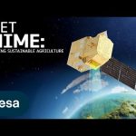
According to the Food and Agriculture Organization (FAO), global agricultural production will need to increase by 60% by 2050 to meet the food demands of the growing global population.
A new satellite called Copernicus Hyperspectral Imaging Mission for the Environment, or CHIME, is being developed to support EU policies on the management of natural resources – ultimately helping to address the global issue of food security.
CHIME will carry a unique visible to shortwave infrared spectrometer to provide routine hyperspectral observations to support new and enhanced services for sustainable agricultural and biodiversity management, as well as soil property characterisation.
CHIME is one of six Copernicus Sentinel Expansion missions that ESA is developing on behalf of the EU. The missions will expand the current capabilities of the Copernicus Space Component – the world’s biggest supplier of Earth observation data.
This video features interviews with Marco Celesti, CHIME Mission Scientist and Jens Nieke, CHIME Project Manager.
Credits: ESA – European Space Agency
★ Subscribe: http://bit.ly/ESAsubscribe and click twice on the bell button to receive our notifications.
We are Europe’s gateway to space. Our mission is to shape the development of Europe’s space capability and ensure that investment in space continues to deliver benefits to the citizens of Europe and the world. Check out https://www.esa.int/ to get up to speed on everything space related.
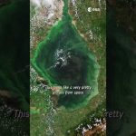
Although nice to see from space, the emerald-green swirls in the lake waters, visible in this image captured in August 2023, denote runaway blooms of toxic cyanobacteria, or blue–green algae, which pose a serious threat to ecology and human health.
With an area of over 13,000 sq km, Lake Maracaibo is generally considered the largest lake in South America, although by some estimates it should be considered an inlet of the Caribbean Sea since much of its water is brought in by its direct connection to the ocean.
📹 @EuropeanSpaceAgency
📸 contains modified Copernicus Sentinel data (2016), processed by ESA, Creative Commons CC BY-SA 3.0 IGO
Tracking ice lost from the world’s glaciers, ice sheets and frozen land shows that Earth is losing ice at an accelerating rate. Monitoring the cryosphere is crucial for assessing, predicting and adapting to climate change.
The Copernicus Polar Ice and Snow Topography Altimeter (CRISTAL) mission will provide a full picture of the changes taking place in some of the most inhospitable regions of the world. It will carry – for the first time – a dual-frequency radar altimeter, and microwave radiometer, that will measure and monitor sea-ice thickness, overlying snow depth and ice-sheet elevations.
These data will support maritime operations in the polar oceans and contribute to a better understanding of climate processes. CRISTAL will also support applications related to coastal and inland waters, as well as providing observations of ocean topography.
CRISTAL is one of six Copernicus Sentinel Expansion missions that ESA is developing on behalf of the EU. The missions will expand the current capabilities of the Copernicus Space Component – the world’s biggest supplier of Earth observation data.
This video features interviews with Kristof Gantois, CRISTAL Project Manager and Paolo Cipollini, CRISTAL Mission Scientist.
Credits: ESA – European Space Agency
★ Subscribe: http://bit.ly/ESAsubscribe and click twice on the bell button to receive our notifications.
We are Europe’s gateway to space. Our mission is to shape the development of Europe’s space capability and ensure that investment in space continues to deliver benefits to the citizens of Europe and the world. Check out https://www.esa.int/ to get up to speed on everything space related.
The Arctic is experiencing disproportionately higher temperature increases compared to the rest of the planet, triggering a series of cascading effects. This rapid warming has profound implications for global climate patterns, human populations and wildlife.
The Copernicus Imaging Microwave Radiometer mission (CIMR) will provide measurements to decision makers with evidence of change and impact in the polar regions – with a focus on the Arctic.
The mission has the largest radiometer developed by ESA and will provide high-resolution measurements related to sea ice, the ocean, snow and ice-sheet surfaces. This will be crucial in understanding the evolution of the climate in the polar region.
CIMR is one of six Copernicus Sentinel Expansion missions that ESA is developing on behalf of the EU. The missions will expand the current capabilities of the Copernicus Space Component – the world’s biggest supplier of Earth observation data.
This video features interviews with Craig Donlon, CIMR Mission Scientist, Rolv Midthassel, CIMR Payload Manager, Claudio Galeazzi, CIMR Project Manager, Mariel Triggianese, CIMR Satellite Engineering and AIV Manager, and Marcello Sallusti, CIMR System Performance and Operations Manager.
In the meantime Craig has changed his role but will retain his position as Mission Scientist.
Credits: ESA – European Space Agency
★ Subscribe: http://bit.ly/ESAsubscribe and click twice on the bell button to receive our notifications.
We are Europe’s gateway to space. Our mission is to shape the development of Europe’s space capability and ensure that investment in space continues to deliver benefits to the citizens of Europe and the world. Check out https://www.esa.int/ to get up to speed on everything space related.
2023’s highlight was the highly anticipated launch of Juice, Europe’s Jupiter Icy Moon Explorer. The Juice spacecraft was placed on course to Jupiter on the second-to-last Ariane 5 launch vehicle in April. After an eight-year journey, Juice will begin observing the giant gas planet and its three large ocean-bearing moons – Ganymede, Calisto and Europa.
The Euclid space telescope was launched in July with the aim of unravelling the enigmas of ‘dark matter’ and ‘dark energy’. Euclid’s first images were released in November, revealing razor-sharp astronomical images with detail never before seen by a telescope across such a large patch of the sky.
After almost five years in space, ESA’s Aeolus wind mission was retired. This trailblazing mission was tasked with observing wind patterns from space thereby improving weather forecasts and climate models.. Aeolus data and technology will have an important role to play in the accuracy of future weather forecasting. On 28 July, it burned up in an assisted re-entry – the first assisted re-entry by a mission which was not designed to do so.
As space debris becomes an increasingly serious issue, ESA is determined to search for solutions. Together with its commercial and institutional partners, ESA has developed the ‘Zero Debris Charter’, launched this year. By signing the Charter, space entities worldwide can register their intent to work together towards the sustainable use of Earth’s orbital environment.
Earlier in in 2023, MTG-I1, the first of the Meteosat Third Generation missions, sent back its first images. The satellite was launched in 2022 and carries two instruments: a flexible combined imager and a lighting imager. Both instruments performed beyond expectation and a stunning combined image from both was revealed.
Earth observation is key to keeping our planet and the population as a whole, safe. Today, monitoring earthquakes, forest fires or flooding from space already helps to coordinate rescue response but the data can also be used to better understand phenomena such as climate change and support the IPCC climate reports.
Last year, NASA’s Dart mission impacted on a small moonlet of the asteroid Didymos, changing its course. We’ll soon be launching ESA’s Hera spacecraft to collect data on the aftermath of this collision. The Hera spacecraft was integrated and underwent testing this year in ESA ESTEC’s test centre in the Netherlands.
2023 also saw the first hardware tests for the second generation of Galileo satellites but even more importantly the Galileo High Accuracy Service was launched in January. This new service delivers centimetre accuracy from space further cementing Galileo’s reputation as the most accurate satellite navigation system in the world.
★ Subscribe: http://bit.ly/ESAsubscribe and click twice on the bell button to receive our notifications.
We are Europe’s gateway to space. Our mission is to shape the development of Europe’s space capability and ensure that investment in space continues to deliver benefits to the citizens of Europe and the world. Check out https://www.esa.int/ to get up to speed on everything space related.
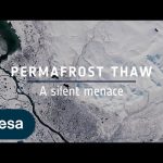
Ice is without doubt one of the first casualties of climate change, but the effects of our warming world are not only limited to ice melting on Earth’s surface. Ground that has been frozen for thousands of years, called permafrost, is thawing – adding to the climate crisis and causing serious issues for local communities.
Scientists estimate that the world’s permafrost holds almost double the amount of carbon that is currently in the atmosphere. When permafrost warms and thaws, it releases methane and carbon dioxide, adding these greenhouse gases to the atmosphere and making global warming even worse.
While permafrost cannot be directly observed from space, a lot of different types of satellite data, along with ground measurements and modelling, allow scientists to paint a picture of permafrost ground conditions.
Credits: ESA – European Space Agency
★ Subscribe: http://bit.ly/ESAsubscribe and click twice on the bell button to receive our notifications.
We are Europe’s gateway to space. Our mission is to shape the development of Europe’s space capability and ensure that investment in space continues to deliver benefits to the citizens of Europe and the world. Check out https://www.esa.int/ to get up to speed on everything space related.
The Copernicus Anthropogenic Carbon Dioxide Monitoring (CO2M) mission will be the first satellite mission to measure how much carbon dioxide is released into the atmosphere through human activity.
CO2M isn’t just a mission; it’s a crucial step in our commitment to understanding and mitigating climate change. It will offer unprecedented precision in monitoring carbon dioxide emissions from the combustion of fossil fuel at national and regional scales.
Its data will provide the EU with a unique and independent source of information to assess the effectiveness of policy measures and to track their impact towards decarbonising Europe ahead of the next Global Stocktake set to place in 2028.
The video features interviews with Valerie Fernandez, CO2M Mission Project Manager, Yannig Durand, CO2M Payload Manager and Yasjka Meijer, CO2M Mission Scientist.
We are Europe’s gateway to space. Our mission is to shape the development of Europe’s space capability and ensure that investment in space continues to deliver benefits to the citizens of Europe and the world. Check out https://www.esa.int/ to get up to speed on everything space related.
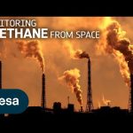
Methane is the second most important greenhouse gas contributor to climate change after carbon dioxide. Curbing methane emissions could deliver immediate and long-lasting benefits for the climate, seeing as the gas only lingers in the atmosphere for a relatively short time. Satellites have a really important role to play in reducing greenhouse gas emissions. The Tropomi instrument onboard the Copernicus Sentinel-5P satellite is the only instrument that maps global methane concentrations every single day. This lets scientists detect hotspots for large methane sources around the world – allowing us to address the consequences of methane emissions on our climate and environment.
Credits: ESA – European Space Agency
★ Subscribe: http://bit.ly/ESAsubscribe and click twice on the bell button to receive our notifications.
We are Europe’s gateway to space. Our mission is to shape the development of Europe’s space capability and ensure that investment in space continues to deliver benefits to the citizens of Europe and the world. Check out https://www.esa.int/ to get up to speed on everything space related.
The summer fire season is well under way in Europe – countries all around the Mediterranean are experiencing record temperatures coupled with huge wildfires that have led to mass evacuations. In this enthralling new ESA documentary, explore how people on the frontline are using space to better monitor and fight the flames.
Follow the incredible stories of the firefighters who dealt with unprecedented fires in Gironde, France, and the forest officers using satellite data to plan for the forests’ recovery. Journey into the heart of Earth’s elemental might and discover how space is changing the game for monitoring volcanic eruptions too – including one of the world’s most studied volcano, Mount Etna.
FIRE is the first episode of ESA’s new series centred around the elements and showcases how Earth observation has become crucial to those fighting climate change on the ground.
Chapters: 00:00 – 11:23 Fighting wildfires in Gironde 11:23 – 24:13 The fire from volcanoes – walking up Mount Etna 24:13 – 31:45 Regenerating the burnt forests and getting ready for the next fire season in Gironde 31:45 – 33:01 Outro
Credits: ESA – European Space Agency
★ Subscribe: http://bit.ly/ESAsubscribe and click twice on the bell button to receive our notifications.
We are Europe’s gateway to space. Our mission is to shape the development of Europe’s space capability and ensure that investment in space continues to deliver benefits to the citizens of Europe and the world. Check out https://www.esa.int/ to get up to speed on everything space related.
Discover the first results from Europe’s first Lightning Imager onboard the Meteosat Third Generation. The Lightning Imager can continuously detect rapid flashes of lighting in Earth’s atmosphere whether day or night from a distance of 36 000 km.
This is the first time a geostationary weather satellite has the capability to detect lightning across Europe, Africa and the surrounding waters. Each camera can capture up to 1000 images per second and will continuously observe lightning activity from space. The data will give weather forecasters greater confidence in their predictions of severe storms.
We are Europe’s gateway to space. Our mission is to shape the development of Europe’s space capability and ensure that investment in space continues to deliver benefits to the citizens of Europe and the world. Check out https://www.esa.int/ to get up to speed on everything space related.
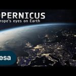
25 years ago, Copernicus set out to transform the way we see our planet. It is the largest environmental monitoring programme in the world. Learn more about the Copernicus programme and the Sentinel satellite missions developed by ESA. 👉 https://www.esa.int/Applications/Observing_the_Earth/Copernicus
Credits: ESA
★ Subscribe: http://bit.ly/ESAsubscribe and click twice on the bell button to receive our notifications.
We are Europe’s gateway to space. Our mission is to shape the development of Europe’s space capability and ensure that investment in space continues to deliver benefits to the citizens of Europe and the world. Check out https://www.esa.int/ to get up to speed on everything space related.
Enjoy a sneak peek of ESA’s new documentary that looks at fire in all its fury – and how satellite technology is helping to mitigate this consequence of climate change. Join us on this journey as we meet the firefighter who fought one of the largest wildfires in his career, climate scientists working with satellite data, and the people on the frontline using these data to aid those affected. The full documentary will be released this summer.
★ Subscribe: http://bit.ly/ESAsubscribe and click twice on the bell button to receive our notifications.
We are Europe’s gateway to space. Our mission is to shape the development of Europe’s space capability and ensure that investment in space continues to deliver benefits to the citizens of Europe and the world. Check out https://www.esa.int/ to get up to speed on everything space related.
As global temperatures increase, the melting of the massive ice sheets that blanket Antarctica and Greenland has accelerated, making a significant contribution to sea-level rise. In total, Earth is losing around a trillion tonnes of ice each year – which is not being replenished.
Andrew Shepherd of the University of Leeds is a leading climate scientist working with ESA and @NASA. Join Andrew as he discusses how long-term satellite observations from ESA’s Climate Change Initiative are key in monitoring changes in ice sheets over decades.
We are Europe’s gateway to space. Our mission is to shape the development of Europe’s space capability and ensure that investment in space continues to deliver benefits to the citizens of Europe and the world. Check out https://www.esa.int/ to get up to speed on everything space related.
1⃣ Climate Detectives – identify a climate problem in your area and investigate how to solve it using Earth Observation data. Learn more: https://climatedetectives.esa.int/
2⃣ AstroPi – write programs for computers placed on the International Space Station. Learn more: https://astro-pi.org/
3⃣ CanSat – build, test and launch a mini satellite the size of a soda can. Learn more: https://cansat.esa.int/
4⃣ PETRI – design and perform experiments investigating the effect of Earth’s gravity on scientific phenomena by using different facilities like Drop Towers, Parabolic Flights and even the International Space Station.
5⃣ Earth Observation courses – thanks to ESA Academy’s Training and Learning Programme, you can follow plenty of courses on different Earth Observation topics like remote sensing, satellite system design and space debris.
Which project would you like to join? Let us know in the comments! ⬇️
📽️ @EuropeanSpaceAgency
★ Subscribe: http://bit.ly/ESAsubscribe and click twice on the bell button to receive our notifications.
We are Europe’s gateway to space. Our mission is to shape the development of Europe’s space capability and ensure that investment in space continues to deliver benefits to the citizens of Europe and the world. Check out https://www.esa.int/ to get up to speed on everything space related.
Have you ever wondered what a volcano looks like from space? Today, we’re counting down our picks of the most impressive volcanoes around the world – captured by satellites. Our countdown includes Mount Fuji, Mount Mayon and Mount Vesuvius.
Are there any volcanoes we missed on our list? Let us know in the comments below.
00:00 – Intro
00:38 – Mount Fuji
01:27 – Mount St. Helens
02:14 – Mauna Loa
02:52 – Fagradalsfjall
03:33 – Kamchatka Peninsula
04:13 – Mount Vesuvius
05:15 – Volcán de Fuego
06:17 – Mount Mayon
07:04 – Emi Koussi
07:57 – Cumbre Vieja
08:47 – Mount Taranaki
09:40 – Galapagos Islands
10:20 – Anak Krakatoa
“Correction:” 2:17 – This footage does not show Mauna Loa but shows the Diamond Head, Hawaii.
“Correction:” 5:39 – This part of the image does not show the lava flow from the Volcán de Fuego
Credits: ESA
★ Subscribe: http://bit.ly/ESAsubscribe and click twice on the bell button to receive our notifications.
We are Europe’s gateway to space. Our mission is to shape the development of Europe’s space capability and ensure that investment in space continues to deliver benefits to the citizens of Europe and the world. Check out https://www.esa.int/ to get up to speed on everything space related.
In the 1980s, scientists discovered a gaping hole in Earth’s ozone layer, caused by humanmade chemicals. But how do we keep track of the status of the ozone hole?
This video briefly explores how satellites orbiting Earth are monitoring the ozone hole.
We are Europe’s gateway to space. Our mission is to shape the development of Europe’s space capability and ensure that investment in space continues to deliver benefits to the citizens of Europe and the world. Check out https://www.esa.int/ to get up to speed on everything space related.
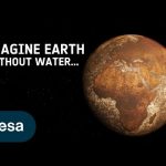
Imagine the world without water: as cold and lifeless as the planet Mars. Earth is unique in our solar system in being able to sustain liquid water on its surface. Water is essential for life and for Earth’s climate, helping transport heat around the planet, but it is difficult to track through the whole water cycle. The global view offered by satellites helps. ESA’s Climate Change Initiative is looking at a range of climate variables linked to the water cycle.
We are Europe’s gateway to space. Our mission is to shape the development of Europe’s space capability and ensure that investment in space continues to deliver benefits to the citizens of Europe and the world. Check out https://www.esa.int/ to get up to speed on everything space related.
In the 1980s, scientists discovered a gaping hole in Earth’s ozone layer, caused by humanmade chemicals. But what is the ozone hole? Join us to find out!
We are Europe’s gateway to space. Our mission is to shape the development of Europe’s space capability and ensure that investment in space continues to deliver benefits to the citizens of Europe and the world. Check out https://www.esa.int/ to get up to speed on everything space related.
The Copernicus Data Space Ecosystem offers immediate access to a wide range of open and free Earth observation data and services. Following from the success of the current Copernicus Data Hub distribution, the new service ensures continuity and extends the portfolio for data access and data processing possibilities.
The Copernicus Data Space Ecosystem represents a significant leap forward in the way users can access and work with Earth observation data. The service aims to further improve access and exploitation of the Copernicus satellites data.
We are Europe’s gateway to space. Our mission is to shape the development of Europe’s space capability and ensure that investment in space continues to deliver benefits to the citizens of Europe and the world. Check out https://www.esa.int/ to get up to speed on everything space related.
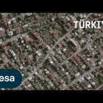
Türkiye and Syria are reeling from one of the worst earthquakes to strike the region in almost a century. Tens of thousands of people have been killed with many more injured in this tragedy. Turkish authorities, along with the United Nations and the International Federation Red Cross & Red Crescent Societies, activated the International Charter ‘Space and Major Disasters’. The Charter provides satellite images of the affected areas to support local teams with their rescue efforts. Philippe Bally, ESA Charter Representative, explains.
We are Europe’s gateway to space. Our mission is to shape the development of Europe’s space capability and ensure that investment in space continues to deliver benefits to the citizens of Europe and the world. Check out https://www.esa.int/ to get up to speed on everything space related.
Mecklenburg–West Pomerania is one of Germany’s least populated states. Nearly two-thirds is covered by farmland with the main crops being rye, wheat, barley and hay. The green areas present in this image are most likely winter wheat and winter rapeseed. The region’s pastures typically support sheep, horses and cattle.
On the state’s coastline on the Baltic Sea lie many holiday resorts, unspoilt nature and the islands of Rügen and Usedom, as well as many others.
We are Europe’s gateway to space. Our mission is to shape the development of Europe’s space capability and ensure that investment in space continues to deliver benefits to the citizens of Europe and the world. Check out https://www.esa.int/ to get up to speed on everything space related.
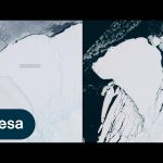
An iceberg around the size of Greater London broke off Antarctica’s Brunt Ice Shelf due to a natural process called ‘calving’. The iceberg, measuring 1550 sq km, detached from the 150 m-thick ice shelf a decade after scientists first spotted massive cracks in the shelf.
We are Europe’s gateway to space. Our mission is to shape the development of Europe’s space capability and ensure that investment in space continues to deliver benefits to the citizens of Europe and the world. Check out https://www.esa.int/ to get up to speed on everything space related.
We are Europe’s gateway to space. Our mission is to shape the development of Europe’s space capability and ensure that investment in space continues to deliver benefits to the citizens of Europe and the world. Check out https://www.esa.int/ to get up to speed on everything space related.