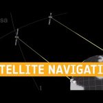
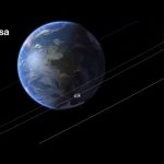
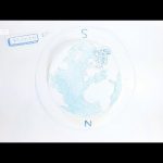
More than two billion smartphones, with users worldwide are now making use of Europe’s Galileo navigation satellite constellation. But how do satellites thousands of kilometres away in space manage to tell you where you are and where you’re going? Simply being so far away is part of the answer – learn the details of the world’s most precise navigation system in this new video.
★ Subscribe: http://bit.ly/ESAsubscribe and click twice on the bell button to receive our notifications.
We are Europe’s gateway to space. Our mission is to shape the development of Europe’s space capability and ensure that investment in space continues to deliver benefits to the citizens of Europe and the world. Check out https://www.esa.int/ to get up to speed on everything space related.
Preparing a small satellite to conduct some big science, an update on our upcoming mission to a metal-rich asteroid, and a new director for the International Space Station … a few of the stories to tell you about – This Week at NASA!
The journey of Resilience to the space station, the next ocean-observing satellite, and an update on a critical rocket test series for our Artemis missions … a few of the stories to tell you about – This Week at NASA!
Download link: images-assets.nasa.gov/video/The Journey of Resilience to The Space Station on This Week @NASA – November 21 2020/The Journey of Resilience to The Space Station on This Week @NASA – November 21 2020~orig.mp4
Producer: Andre Valentine
Editor: Sonnet Apple
Music: Universal Production Music
Satellite navigation is a big part of our daily lives. How do our phones and cars know where to go? Nicola de Quattro, head of engineering and innovation at Vitrociset Belgium, explains how sat nav works along with its present and future applications in this episode of Meet the Experts.
We are Europe’s gateway to space. Our mission is to shape the development of Europe’s space capability and ensure that investment in space continues to deliver benefits to the citizens of Europe and the world. Check out http://www.esa.int/ESA to get up to speed on everything space related.
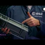
What would you do with a powerful computer based in space? At just 30 cm in height, OPS-SAT is a tiny CubeSat designed to serve as a large-scale software laboratory in orbit – containing one of the most powerful flight computers ever flown – to test innovative control software from teams all over Europe. Anyone can apply to try out their software aboard OPS-SAT, from companies to research teams to computer clubs, linking directly from the internet. The small satellite packs in a high-resolution camera, radio antennas, optical receiver, reaction wheels and GPS. OPS-SAT can be rebooted if any experimental software crashes, allowing otherwise risky inflight testing as a way to make space smarter.
★ Subscribe: http://bit.ly/ESAsubscribe and click twice on the bell button to receive our notifications.
We are Europe’s gateway to space. Our mission is to shape the development of Europe’s space capability and ensure that investment in space continues to deliver benefits to the citizens of Europe and the world. Check out http://www.esa.int/ESA to get up to speed on everything space related.
On 17 December, ESA will launch a first-of-its-kind space laboratory, OPS-SAT. The small, low-cost test satellite has been specifically designed for operational experiments in space, and includes the most powerful flight computer on board any current ESA spacecraft.
Consumer electronics have gone through a revolution over the last 30 years with computers becoming ever faster, smaller and better. But when it comes to million- or even billion-euro satellites, their onboard hardware and software have not seen this revolution because of the risks of testing new technology in flight.
As spacecraft managers dare to fly only tried-and-tested hard and software in the harsh conditions of space, innovation on the operational side of satellites is a very slow-moving process. This is where OPS-SAT steps in, bringing down the barriers to spacecraft operations it provides a chance to safely test out new mission control techniques.
Anyone can apply to become an ‘experimenter’ and test their innovative software and new mission operations techniques in space. Proving technology for future missions and paving the way for satellites to further evolve with minimum risk, OPS-SAT will be launched with ESA’s Cheops satellite from Europe’s Spaceport in Kourou, French Guiana.
★ Subscribe: http://bit.ly/ESAsubscribe and click twice on the bell button to receive our notifications.
We are Europe’s gateway to space. Our mission is to shape the development of Europe’s space capability and ensure that investment in space continues to deliver benefits to the citizens of Europe and the world. Check out http://www.esa.int/ESA to get up to speed on everything space related.
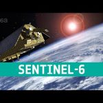
In a cleanroom in Ottobrunn, Germany, the latest Copernicus Sentinel satellite is ready for final testing before it is packed up and shipped to the US for liftoff next year. Designed and built to chart changing sea level, it is the first of two identical Sentinel-6 satellites that will be launched consecutively to continue the time series of sea-level measurements. This new mission builds on heritage from previous ocean topography satellites, including the French–US Topex-Poseidon and Jason missions, previous ESA missions such as the ERS satellites, Envisat and CryoSat, as well as Copernicus Sentinel-3. With millions of people around the world at risk from rising seas, it is essential to continue measuring the changing height of the sea surface so that decision-makers are equipped to take appropriate mitigating action – as is being currently highlighted at the COP-25 Climate Change Conference in Spain.
We are Europe’s gateway to space. Our mission is to shape the development of Europe’s space capability and ensure that investment in space continues to deliver benefits to the citizens of Europe and the world. Check out http://www.esa.int/ESA to get up to speed on everything space related.
SMOS has been in orbit for a decade. This remarkable satellite has not only exceeded its planned life in orbit, but also surpassed its original scientific goals. It was designed to deliver data on soil moisture and ocean salinity which are both crucial components of Earth’s water cycle. By consistently mapping these variables, SMOS is not only advancing our understanding of the water cycle and the exchange processes between Earth’s surface and the atmosphere, but is also helping to improve weather forecasts and contributing to climate research as well as contributing to a growing number practical everyday applications.
We are Europe’s gateway to space. Our mission is to shape the development of Europe’s space capability and ensure that investment in space continues to deliver benefits to the citizens of Europe and the world. Check out http://www.esa.int/ESA to get up to speed on everything space related.
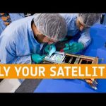
Fly Your Satellite! is an educational programme for university students, created by ESA after the launch of seven university CubeSats on the 2012 Vega maiden flight. Six teams participated in the first edition of the programme, which concluded in 2016 with the launch of three satellites, while in parallel a pilot edition was undertaken to deploy a satellite from the International Space Station. The second edition of Fly Your Satellite! is currently ongoing since 2017, and participating university teams are advancing closer towards testing and launch. The call for proposals for the third edition is now open.
We are Europe’s gateway to space. Our mission is to shape the development of Europe’s space capability and ensure that investment in space continues to deliver benefits to the citizens of Europe and the world. Check out http://www.esa.int/ESA to get up to speed on everything space related.
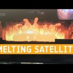
Researchers took one of the heaviest, bulkiest parts of an Earth-orbiting satellite, placed it in a plasma wind tunnel, then proceeded to melt it into vapour. Their goal was to better understand how satellites burn up during reentry, to minimise the risk of endangering anyone on the ground.
Taking place as part of our Clean Space initiative, the fiery testing occurred inside a plasma wind tunnel, reproducing reentry conditions, at the DLR German Aerospace Center’s site in Cologne.
A magnetotorquer – designed to interact magnetically with Earth’s magnetic field to shift satellite orientation – was heated to several thousands of degrees C within the hypersonic plasma.
As part of a larger effort called CleanSat, we are developing technologies and techniques to ensure future low-orbiting satellites are designed according to the concept of ‘D4D’ – design for demise – ensuring they will burn up entirely when they reenter the atmosphere.
We are Europe’s gateway to space. Our mission is to shape the development of Europe’s space capability and ensure that investment in space continues to deliver benefits to the citizens of Europe and the world. Check out http://www.esa.int/ESA to get up to speed on everything space related.
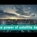
Satellites provides us with large volumes of spatio-temporal data, creating great opportunities for innovative entrepreneurs. ESA’s Business Applications programme is supporting European projects to turn these data into solutions for a wide range of socio-economic situations, as well as jobs and products. This video highlights three concrete examples: automated trains, rehabilitation and money transfers in isolated areas.
★ Subscribe: http://bit.ly/ESAsubscribe and click twice on the bell button to receive our notifications.
ESA is Europe’s gateway to space. Our mission is to shape the development of Europe’s space capability and ensure that investment in space continues to deliver benefits to the citizens of Europe and the world. Check out http://www.esa.int/ESA to get up to speed on everything space related.
Everybody is talking about 5G, the new generation of wireless communication. We are at the start of a revolution in connectivity for everything, everywhere, at all times.
Space plays at important roll in this revolution. We need satellites to ensure businesses and citizens can benefit smoothly from 5G.
★ Subscribe: http://bit.ly/ESAsubscribe and click twice on the bell button to receive our notifications.
ESA is Europe’s gateway to space. Our mission is to shape the development of Europe’s space capability and ensure that investment in space continues to deliver benefits to the citizens of Europe and the world. Check out http://www.esa.int/ESA to get up to speed on everything space related.
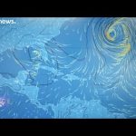
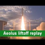
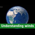
Following the launch of Aeolus on 22 August 2018, scientists have been busy fine-tuning and calibrating this latest Earth Explorer satellite. Aeolus carries a revolutionary instrument, which comprises a powerful laser, a large telescope and a very sensitive receiver. It works by emitting short, powerful pulses – 50 pulses per second – of ultraviolet light from a laser down into the atmosphere. The instrument then measures the backscattered signals from air molecules, dust particles and water droplets to provide vertical profiles that show the speed of the world’s winds in the lowermost 30 km of the atmosphere. These measurements are needed to improve weather forecasts. As part of the working being done to calibrate this novel mission, scientists have been taking similar measurements from an aircraft carrying an airborne version of Aeolus’ instrument. The pilot flies the plane under the satellite as it orbits above so that measurements of wind can be compared.
ESA is Europe’s gateway to space. Our mission is to shape the development of Europe’s space capability and ensure that investment in space continues to deliver benefits to the citizens of Europe and the world. Check out http://www.esa.int/ESA to get up to speed on everything space related.
After 11 years of 🌌breathtaking imagery, ⚙️unprecedented feats of engineering & 🛰️spacecraft records broken — it’s nearly time to bid farewell to NASA’s Dawn spacecraft as it comes to the expected end of the mission. Learn about its final orbits at Ceres: https://go.nasa.gov/dawnfinale
This edition of #Space comes from the coast of northern Norway, where we’ve come to the Andøya Space Centre to meet scientists working on a new satellite called Aeolus. This mission carries revolutionary laser technology to measure the wind around the entire globe. Lofted into orbit in August 2018 on a Vega rocket from French Guiana, Aeolus has only just begun its life in space. Engineers are now busy commissioning the mission to ensure that it will soon be ready to deliver novel data on winds. This will be used to improve our understanding of the atmosphere and to improve weather forecasts.
ESA is Europe’s gateway to space. Our mission is to shape the development of Europe’s space capability and ensure that investment in space continues to deliver benefits to the citizens of Europe and the world. Check out http://www.esa.int/ESA to get up to speed on everything space related.
#Space című műsorunkban ezúttal Észak-Norvégiából jelentkezünk, ahol az Andøya űrközpontban tudósokkal találkoztunk, akik egy új műholdon, az Aeolus-on dolgoznak. Ez egyedülálló módon az űrből méri a Föld szeleit. A tudósok jelenleg azon dolgoznak, hogy kalibrálják és érvényesítsék a méréseket, amelyeket a föld körüli pályáról kapnak. A Vega-rakéta robajával úttörő időjárási küldetés kezdődik: az Európai Űrügynökség régóta várt Aeolus-műholdját augusztus végén kilőtték az űrbe. A műhold gyorsan és alacsonyan repül, mindössze 320 kilométeres magasságban.
ESA is Europe’s gateway to space. Our mission is to shape the development of Europe’s space capability and ensure that investment in space continues to deliver benefits to the citizens of Europe and the world. Check out http://www.esa.int/ESA to get up to speed on everything space related.
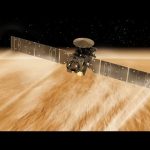
ESA’s Earth Explorer Aeolus satellite lifted off on a Vega rocket from Europe’s Spaceport in Kourou, French Guiana, at 21:20 GMT (23:20 CEST, 18:20 local time) on 22 August 2018. Aeolus carries one of the most sophisticated instruments ever to be put into orbit. The first of its kind, the Aladin instrument includes revolutionary laser technology to generate pulses of ultraviolet light that are beamed down into the atmosphere to profile the world’s winds – a completely new approach to measuring the wind from space. By profiling the lowermost 30 km of the atmosphere, Aeolus will give scientists global information on the speed of the wind in near-real time. This will improve our understanding of how wind, pressure, temperature and humidity are interlinked. This new mission will also provide insight into how the wind influences the exchange of heat and moisture between Earth’s surface and the atmosphere. These aspects are important for understanding climate change. As well as advancing science and improving weather forecasts, data from Aeolus will be used in air-quality models to improve forecasts of dust and other airborne particles that affect public health.
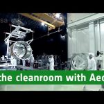
Discover more about our planet with the Earth from Space video programme. In this special edition, ESA’s Aeolus mission scientist, Anne Grete Straume, joins us in the cleanroom at Airbus Defence and Space in Toulouse, France. She explains how winds are generated, how they affect our weather, and how Aeolus will measure the wind and how this information will be used to improve weather forecasts and climate models.
Discover more about our planet with the Earth from Space video programme. In this special edition, ESA’s Aeolus Project Manager, Anders Elfving, joins us in the cleanroom at Airbus Defence and Space in Toulouse, France, to talk about the challenges in developing the mission’s pioneering laser technology.
5G, the next generation of communication services, will deliver ultra-fast speeds, connect all people and devices to the internet and minimise delays. It will affect everybody, changing the way we communicate, work and interact with technology.
Space has an invaluable role to play in the 5G ecosystem. Satellites can extend, enhance, and provide reliability and security to 5G like no other, helping to deliver its promise of global, ubiquitous connectivity, with no noticeable difference to the end-user. ESA’s Satellite for 5G (S45G) programme aims promote the value-added benefits of space to 5G, by developing and demonstrating integrated satellite- and terrestrial-based 5G services, across multiple markets and use cases.
Having a stressful day? We got you covered! Sit back, turn the volume up and enjoy a relaxing moment brought to you by ESA and Lufthansa exploring the countries which make up the European Space Agency with images taken by the Copernicus Sentinel-1A, Sentinel-2A and Sentinel-3A, Proba-V and Envisat satellites.
Don’t forget to favourite this video. You will always have a space to relax with us.
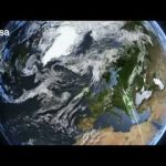
Earth from Space is presented by Kelsea Brennan-Wessels from the ESA Web TV virtual studios. In this edition, Sentinel-3A treats us to a view stretching from Sardinia to Romania.
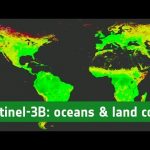
Following its launch in February 2016 and subsequent commissioning phase, the Copernicus Sentinel-3A satellite has been systematically measuring our oceans, land, ice and atmosphere. The information feeds a range of practical applications and is used for monitoring and understanding large-scale global dynamics. Sentinel-3A will soon be joined in orbit by its identical twin, Sentinel-3B. Both satellites carry a suite of cutting-edge instruments to supply a new generation of data products, which are particularly useful for marine applications. For example, they monitor ocean-surface temperatures for ocean and weather forecasting services, aquatic biological productivity, ocean pollution and sea-level change. The mission also delivers unique and timely information about changing land cover, vegetation, urban heat islands, and for tracking wildfires. With the two satellites in orbit, global coverage and data delivery will be optimised.
Since arriving at Mars in October 2016, the ExoMars Trace Gas Orbiter has been aerobraking its way into a close orbit of the Red Planet by using the top of the atmosphere to create drag and slow down. It is almost in the right orbit to begin observations – only a few hundred kilometres to go! With aerobraking complete, additional manoeuvres will bring the craft into a near-circular two-hour orbit, about 400 km above the planet, by the end of April. The mission’s main goal is to take a detailed inventory of the atmosphere, sniffing out gases like methane, which may be an indicator of active geological or biological activity. The camera will help to identify surface features that may be related to gas emissions. The spacecraft will also look for water-ice hidden below the surface, which could influence the choice of landing sites for future exploration. It will also relay large volumes of science data from NASA’s rovers on the surface back to Earth and from the ESA–Roscosmos ExoMars rover, which is planned for launch in 2020.
ESA’s Earth Explorer Aeolus satellite will be launched later this year to measure the world’s winds from space. The satellite carries one of the most sophisticated instruments ever to be put into orbit: Aladin, which includes two powerful lasers, a large telescope and very sensitive receivers. The laser generates ultraviolet light that is beamed down into the atmosphere to profile the world’s winds – a completely new approach to measuring the wind from space. These vertical slices through the atmosphere, along with information it gathers on aerosols and clouds, will improve our understanding of atmospheric dynamics and contribute to climate research. As well as advancing science, Aeolus will play an important role in improving weather forecasts. The mission will also complement information about the atmosphere being provided by the Copernicus Sentinel missions.
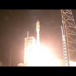
On Friday, August 18, NASA launched the third in a series of three advanced, Tracking and Data Relay Satellites, known as TDRS-M, from Cape Canaveral Air Force Station, in Florida. This latest addition to the fleet will augment a space communications network that provides the critical path for high data-rate communication to a host of spacecraft including the International Space Station and its resupply vehicles, the Hubble Space Telescope and many of NASA’s Earth-observing fleet spacecraft.
NASA successfully launched eight small satellites that will provide scientists with advanced technology to see inside tropical storms and hurricanes like never before. Called the Cyclone Global Navigation Satellite System (CYGNSS), the constellation of eight microsatellite observatories launched Dec. 12 aboard an Orbital ATK air-launched Pegasus XL launch vehicle from Cape Canaveral Air Force Station in Florida. The rocket was dropped and launched from Orbital’s Stargazer L-1011 aircraft over the Atlantic Ocean off the coast of central Florida.
The first spacecraft in a new series of NASA-built advanced geostationary weather satellites launched into orbit aboard a United Launch Alliance Atlas V rocket Nov. 19 from Cape Canaveral Air Force Station in Florida. Once in geostationary orbit, GOES-R will be known as GOES-16 and will provide images of weather patterns and severe storms as regularly as every five minutes or as frequently as every 30 seconds. These images can be used to aid in weather forecasts, severe weather outlooks, watches and warnings, lightning conditions, maritime forecasts and aviation forecasts.
ESA’s proposed e.Deorbit mission plans to demonstrate the retrieval and disposal of a derelict satellite from low-Earth orbit. The mission needs to capture a massive, drifting object left in an uncertain state, which may well be tumbling rapidly. Several capture mechanisms are being studied in parallel – including casting a net.
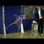
Polish company SKA Polska won this new ESA Member State’s first competitive contract to design a prototype net gun that could be tested in microgravity on a parabolic flight. Wojtek Gołebiowski of SKA Polska brought it along to the Industry Days of ESA’s Clean Space initiative – tasked with safeguarding both terrestrial and orbital environments – in May 2016. The net gun is comparatively low power (because it was designed for weightlessness) but here he demonstrates how it works on some low-flying drones. Results from firing the net, which is multi-coloured to make it easier to track by cameras, are being used to sharpen the fidelity of software models of net behaviour.
Tiny satellites the size of a small cube, jam-packed with the most advanced nanotechnologies: is this the future of Space missions?
To find out, ESA Euronews went to Tallin, Estonia, where students at the Mektory Space Centre are preparing the launch of their first nanosatellite.
Nanosatellites – tiny cubes of 10cm x 10cm x 10cm, full of nanotechnologies — are going to be more and more important in the future of space exploration, from Mars missions, to the surveillance of asteroids, which could potentially be dangerous for our planet.
Also known as ‘CubeSats’ these tiny satellites open up a whole world of possibilities for those who want to explore space.
Plymouth is one of England’s historic port cities, a place from which sailors, soldiers and scientists have set off to sea for centuries. Today there’s a new twist to the tale though, as oceanographers now have a huge fleet of satellites in space to add to their list of high quality data sources in order to study and understand our seas.
The field of satellite ocean observation is due to get a boost later this year as ESA’s Sentinel-3 will join the fleet of Earth observers already in orbit. It’s part of Europe’s Copernicus programme, and heralds a new era in ocean observation by offering an uninterrupted flow of data from its speedy polar orbit, now and well into the future.
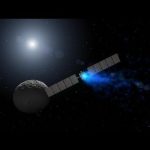
Last summer, they were considered lost: two Galileo satellites ended in the wrong orbit after their launch by a Soyuz from Kourou, French Guiana. But now the two satellites have been recovered and they should be able to fulfil at least partially their mission – a situation made possible thanks to expertise and hard work in the extended Galileo team, from ESA, to agencies partners and industry.
Accurate information about the environmental is crucial. It helps to understand how our planet and climate are changing, the role human activity play in these changes and how this affects our daily lives. Responding to these challenges, the EU and ESA have developed an Earth observation programme called Copernicus, formerly known as Global Monitoring for Environment and Security, – a programme that becomes operational with the launch of Sentinel-1A.
Singer Tasmin Archer kindly sent this message to Europe’s ‘sleeping satellite’, ESA’s comet-chaser Rosetta. Thanks, Tasmin!
Tasmin Archer is the well-known British singer, whose song ‘Sleeping Satellite’ about the Apollo missions to the Moon was her first single released in 1992. The song went to Number 1 in the UK and Ireland singles charts, and also broke into the US, German and Australian music charts. The song has been covered by numerous artists, including Kim Wilde. Tasmin famously performed an acoustic version of Sleeping Satellite at the International Astronautical Congress Opening ceremony in Glasgow, September 2008 (see http://youtu.be/owYZOOIXUAs).
Video copyright: T. Archer Sleeping Satellite written by: T. Archer, J. Beck, J. Hughes (courtesy Quiverdisc) Video produced by tasminarcher.com
Earth’s magnetic field is continuously changing. Magnetic north wanders, and every few hundred thousand years the polarity gradually flips, so that a compass would point south instead of north.
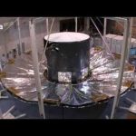
Gaia Deployable Sunshield Assembly (DSA) integrated onto the spacecraft and undergoing deployment testing at Astrium Toulouse. Since the DSA will operate in microgravity, it is not designed to support its own weight in the one-g environment at Earth’s surface. During deployment testing, the DSA panels are attached to a system of support cables and counterweights that bears their weight, preventing damage and providing a realistic test environment. The support system is clearly visible in the video.
As the DSA deploys, the flight model thermal tent comes into view and the mechanically representative dummy payload can be seen through the aperture in the tent. Towards the end of the deployment sequence, the flight model service module comes into view.
This test demonstrated correctness of alignment following integration, confirmed the deployment functionality and verified the flatness of the deployed DSA.
The video shows an edited, time-lapse sequence from the deployment of the DSA during a test campaign; the entire deployment sequence takes about 20 minutes.
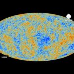
Scientists have traced a unique new map of the first light of the universe, and raised profound questions about the Big Bang.The image of the cosmic microwave background they have released was taken by ESA’s Planck satellite, and its results could have a significant impact on the field of cosmology.
“It turns that most of this image, most of this map, fits beautifully our very simple model. At the same time we find some strange things, and this is where it starts to get interesting, because we see some signs of things that do not fit,” explains ESA’s Planck Project Scientist Jan Tauber.
“Roughly speaking the things that we are finding that are not as we expect are features that are across the whole sky. When you look only at the large features on this map you find that that our best fitting model, our best theory has a problem fitting the data, there is a lack of signal that we would expect to see,” he says.
The news that the early universe is not quite as was thought has left the greatest minds in cosmology spinning with excitement.
George Efstathiou, Professor of Astrophysics, University of Cambridge, is a key member of the Planck Science Team.
“The idea that you can actually experimentally test what happened at the Big Bang still amazes me,” he says.
The Big Bang theory remains intact of course, but the concept of inflation could be put to test by the Planck data.
“We see these strange patterns that are not expected in inflationary theory, the simplest inflationary theories,” explains Efstathiou.
“So there’s a real possibility that we have an incomplete picture. It may be that we have been fooled, that inflation didn’t happen. It’s perfectly possible that there was some phase of the universe before the Big Bang actually happened where you can track the history of the universe to a pre-Big Bang period.”
The Planck mission could test ideas about how the early universe was formed.The puzzle is that at small scales the data fits the theoretical model very nicely, but at larger scales the signal from the cosmic microwave background is much weaker than expected.
Efstathiou is looking for answers: “Can we find a theoretical explanation that links together the different phenomena that we have seen, the different little discrepancies, with inflationary theory? That’s where there’s the potential for a paradigm shift, because at the moment there’s no obvious theoretical explanation that links together these anomalies that we have seen. But if you found a theory that links phenomena that were previously unrelated, then that’s a pointer to new physics.”
It appears that the audacious Planck mission really will shed new light on the dawn of time.
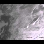
The meteor that exploded over the Urals of central Russia was seen by Eumetsat’s Meteosat-9, at the edge of the satellite view. Hundreds of people were reportedly injured as the meteor’s massive sonic boom caused widespread damage.