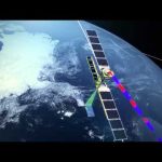
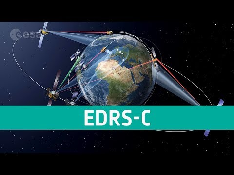
Launched in April 2014, Sentinel-1A carries an advanced radar instrument to image Earth’s surface through cloud and rain, regardless of whether it is day or night. Among its many applications Sentinel-1 routinely monitors shipping zones, maps sea ice and provides information on winds and waves for marine traffic, tracks changes in the way land is being use and provides imagery for rapid response to disasters such as floods, and monitors uplift and subsidence. The satellite transmits data to Earth when passing over ground stations in Norway, Italy and Spain. For continual data delivery, the satellite is also equipped with a laser terminal to transmit data to satellites in geostationary orbit carrying the European Data Relay System (EDRS). These satellites then transmit the Sentinel-1 data to the ground. Complementing the Sentinel ground-station network, EDRS will ensure the timely availability of large volumes of data.
Currently, a precursor optical communications terminal and downlink system is carried on the geostationary Alphasat, Europe’s largest telecommunications satellite. The first EDRS element will be carried on the Eutelsat-9B satellite, which will be launched in 2015. In the meantime, Sentinel-1A can use the precursor instrument on Alphasat to further improve the availability of its data. Sentinel-2A, scheduled to be launched in the spring of 2015, also carries the same optical communications payload.

Leave a Reply