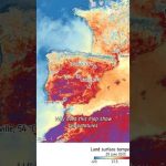
Satellites like Copernicus Sentinel-3 measure land surface temperature — that’s the heat coming directly from the ground, not the air above it. And yes, it’s often hotter in the summer than what your app tells you.
📹 European Space Agency (ESA) 📸 Contains modified Copernicus Sentinel data (2025), processed by ESA
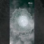
A new study shows that the Nord Stream methane leak that happened in 2022 was bigger than we thought. How much bigger? Watch our video until the end to find out.
📹 European Space Agency (ESA) 📸 Pexels, contains modified Copernicus Sentinel data (2022), processed by ESA, GHGSat, Pléiades Neo, Planet Labs PBC
As recently reported by Copernicus ECMWF in its European State of the Climate Report, Europe experienced several climate extremes like glacier ice loss, severe floods, wildfires, and heatwaves. But the continent didn’t experience the same weather uniformly: data show a distinct east‑west contrast during 2024, with eastern areas generally sunny and warm while western areas were cloudier and wetter.
📹 European Space Agency (ESA) 📸 Contains modified CopernicusEU Sentinel data (2022 & 2024), processed by ESA CC BY-SA 3.0 IGO 📊 C3S/Copernicus ECMWF/KNMI
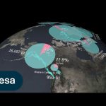
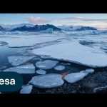
As part of a community effort, the Glacier Mass Balance Intercomparison Exercise, Glambie, has compiled all major studies using observations from a wealth of different techniques to provide an estimate of the world’s glacier mass change over the last two decades. The results, published in the journal Nature, show that ice melting from glaciers around the world is depleting regional freshwater resources and driving global sea levels to rise at ever-faster rates. The animation here illustrates the different observation methods used in the research, and Vatnajökull in Iceland as an example.
We are Europe’s gateway to space. Our mission is to shape the development of Europe’s space capability and ensure that investment in space continues to deliver benefits to the citizens of Europe and the world. Check out https://www.esa.int/ to get up to speed on everything space related.
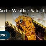
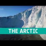
The effects of the climate crisis are felt more acutely in the Arctic than anywhere else on the planet. The weather in the Arctic is not only severe, but it changes extremely quickly. More frequent data are urgently needed to improve weather forecasts for this susceptible polar region.
Enter ESA’s Arctic Weather Satellite: a brand new prototype mission to show exactly how this can be achieved. The satellite will provide precise, short-term weather forecasts for the Arctic region. It is equipped with a 19-channel cross-track scanning microwave radiometer which will provide high-resolution humidity and temperature soundings of the atmosphere in all weather conditions.
The Arctic Weather Satellite is the forerunner of a potential constellation of satellites, called EPS-Sterna, that ESA would build for Eumetsat if this first prototype Arctic Weather Satellite performs well.
Credits: ESA – European Space Agency
★ Subscribe: http://bit.ly/ESAsubscribe and click twice on the bell button to receive our notifications.
We are Europe’s gateway to space. Our mission is to shape the development of Europe’s space capability and ensure that investment in space continues to deliver benefits to the citizens of Europe and the world. Check out https://www.esa.int/ to get up to speed on everything space related.
ESA’s EarthCARE mission is ready for lift-off! EarthCARE is a groundbreaking satellite mission designed to unravel the mysteries of Earth’s clouds and aerosols. EarthCARE will shed light on the role that clouds and aerosols play in heating and cooling Earth’s atmosphere – contributing to our better understanding of climate change. During our live coverage, we’ll hear from mission scientists and spacecraft operators, then follow the launch on a SpaceX Falcon 9 from California, expected at 00:20 CEST. Live from ESA’s spacecraft operations centre in Germany, we take you into the main control room around 01:12 CEST for the satellite’s acquisition of signal – EarthCARE’s first sign of life from space.
Credits: ESA/SpaceX
Timestaps of the video: 00:00 – 38:24 – Start of ESA WebTV Programme – Live from the European Space Operations Centre 38:25 – 50:44 – SpaceX live broadcast begins 50:45 – 1:01:40 – Lift-off 1:01:41 – 1:06:35 – Spacecraft deployment 1:06:36 – 1:40:40 – Stay tuned 1:40:41 – 1:44:50 – ESA WebTV Programme – Live from the European Space Operations Centre 1:44:51 – 1:55:00 – Acquisition of signal
★ Subscribe: http://bit.ly/ESAsubscribe and click twice on the bell button to receive our notifications.
We are Europe’s gateway to space. Our mission is to shape the development of Europe’s space capability and ensure that investment in space continues to deliver benefits to the citizens of Europe and the world. Check out https://www.esa.int/ to get up to speed on everything space related.
As we approach the launch of ESA’s EarthCARE mission, we caught up with some of the scientists, engineers and experts behind the mission.
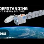
With the climate crisis increasingly tightening its grip, ESA’s Earth Cloud Aerosol and Radiation Explorer mission (EarthCARE) will shed new light on the complex interactions between clouds, aerosols and radiation in Earth’s atmosphere.
EarthCARE is the largest and most complex Earth Explorer mission. It comes at a critical time in the development of kilometre-scale resolution, global climate models and will provide an important contribution to an improved understanding of cloud convection and its role in Earth’s radiation budget.
EarthCARE is an ESA mission, but it has been developed as a cooperation between ESA and JAXA, the Japanese Space Agency.
This video features interviews with: Pavlos Kollias from Stony Brook University – McGill University, Thorsten Fehr, EarthCARE Mission Scientist at ESA, Robin Hogan, Senior Scientist at ECMWF, Dirk Bernaerts, EarthCARE Project Manager at ESA, Kotska Wallace, Mission and Optical Payload Manager at ESA, Tomomi Nio, EarthCARE Mission Manager at JAXA, Eiichi Tomita, EarthCARE/CPR Project Manager at JAXA, Ulla Wandinger, Senior Scientist at Leibniz Institute for Tropospheric Research and Bjoern Frommknecht, EarthCARE Mission Manager at ESA.
Follow the EarthCARE launch campaign blog for more updates.
Credits: ESA – European Space Agency
★ Subscribe: http://bit.ly/ESAsubscribe and click twice on the bell button to receive our notifications.
We are Europe’s gateway to space. Our mission is to shape the development of Europe’s space capability and ensure that investment in space continues to deliver benefits to the citizens of Europe and the world. Check out https://www.esa.int/ to get up to speed on everything space related.
After years of development and a rigorous testing programme, ESA’s EarthCARE satellite has left Munich, Germany, and is now on its away to SpaceX’s launch site in Vandenberg, California. Once it arrives, it will be put into storage for a few weeks until it is time to ready the satellite for liftoff – which is scheduled to launch in May on a Falcon 9 rocket.
The Earth Cloud Aerosol and Radiation Explorer, or EarthCARE for short, is the most complex Earth Explorer mission to date. The new satellite will look at the role that clouds and aerosols play in heating and cooling Earth’s atmosphere – contributing to our understanding of climate change.
With its unique set of four instruments, EarthCARE will examine the role clouds and aerosols play in reflecting solar radiation back into space and also in trapping infrared radiation emitted from Earth’s surface.
EarthCARE is a joint venture between ESA and JAXA, the Japan Aerospace Exploration Agency.
This video features interviews with Simonetta Cheli, Director of Earth Observation Programmes at ESA, Thorsten Fehr, ESA’s EarthCARE Mission Scientist, Dirk Bernaerts, ESA’s EarthCARE Project Manager and Eiichi Tomita, JAXA’s EarthCARE/CPR Project Manager.
Credits: ESA – European Space Agency
★ Subscribe: http://bit.ly/ESAsubscribe and click twice on the bell button to receive our notifications.
We are Europe’s gateway to space. Our mission is to shape the development of Europe’s space capability and ensure that investment in space continues to deliver benefits to the citizens of Europe and the world. Check out https://www.esa.int/ to get up to speed on everything space related.
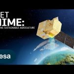
According to the Food and Agriculture Organization (FAO), global agricultural production will need to increase by 60% by 2050 to meet the food demands of the growing global population.
A new satellite called Copernicus Hyperspectral Imaging Mission for the Environment, or CHIME, is being developed to support EU policies on the management of natural resources – ultimately helping to address the global issue of food security.
CHIME will carry a unique visible to shortwave infrared spectrometer to provide routine hyperspectral observations to support new and enhanced services for sustainable agricultural and biodiversity management, as well as soil property characterisation.
CHIME is one of six Copernicus Sentinel Expansion missions that ESA is developing on behalf of the EU. The missions will expand the current capabilities of the Copernicus Space Component – the world’s biggest supplier of Earth observation data.
This video features interviews with Marco Celesti, CHIME Mission Scientist and Jens Nieke, CHIME Project Manager.
Credits: ESA – European Space Agency
★ Subscribe: http://bit.ly/ESAsubscribe and click twice on the bell button to receive our notifications.
We are Europe’s gateway to space. Our mission is to shape the development of Europe’s space capability and ensure that investment in space continues to deliver benefits to the citizens of Europe and the world. Check out https://www.esa.int/ to get up to speed on everything space related.
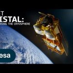
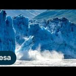
Tracking ice lost from the world’s glaciers, ice sheets and frozen land shows that Earth is losing ice at an accelerating rate. Monitoring the cryosphere is crucial for assessing, predicting and adapting to climate change.
The Copernicus Polar Ice and Snow Topography Altimeter (CRISTAL) mission will provide a full picture of the changes taking place in some of the most inhospitable regions of the world. It will carry – for the first time – a dual-frequency radar altimeter, and microwave radiometer, that will measure and monitor sea-ice thickness, overlying snow depth and ice-sheet elevations.
These data will support maritime operations in the polar oceans and contribute to a better understanding of climate processes. CRISTAL will also support applications related to coastal and inland waters, as well as providing observations of ocean topography.
CRISTAL is one of six Copernicus Sentinel Expansion missions that ESA is developing on behalf of the EU. The missions will expand the current capabilities of the Copernicus Space Component – the world’s biggest supplier of Earth observation data.
This video features interviews with Kristof Gantois, CRISTAL Project Manager and Paolo Cipollini, CRISTAL Mission Scientist.
Credits: ESA – European Space Agency
★ Subscribe: http://bit.ly/ESAsubscribe and click twice on the bell button to receive our notifications.
We are Europe’s gateway to space. Our mission is to shape the development of Europe’s space capability and ensure that investment in space continues to deliver benefits to the citizens of Europe and the world. Check out https://www.esa.int/ to get up to speed on everything space related.
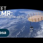
The Arctic is experiencing disproportionately higher temperature increases compared to the rest of the planet, triggering a series of cascading effects. This rapid warming has profound implications for global climate patterns, human populations and wildlife.
The Copernicus Imaging Microwave Radiometer mission (CIMR) will provide measurements to decision makers with evidence of change and impact in the polar regions – with a focus on the Arctic.
The mission has the largest radiometer developed by ESA and will provide high-resolution measurements related to sea ice, the ocean, snow and ice-sheet surfaces. This will be crucial in understanding the evolution of the climate in the polar region.
CIMR is one of six Copernicus Sentinel Expansion missions that ESA is developing on behalf of the EU. The missions will expand the current capabilities of the Copernicus Space Component – the world’s biggest supplier of Earth observation data.
This video features interviews with Craig Donlon, CIMR Mission Scientist, Rolv Midthassel, CIMR Payload Manager, Claudio Galeazzi, CIMR Project Manager, Mariel Triggianese, CIMR Satellite Engineering and AIV Manager, and Marcello Sallusti, CIMR System Performance and Operations Manager.
In the meantime Craig has changed his role but will retain his position as Mission Scientist.
Credits: ESA – European Space Agency
★ Subscribe: http://bit.ly/ESAsubscribe and click twice on the bell button to receive our notifications.
We are Europe’s gateway to space. Our mission is to shape the development of Europe’s space capability and ensure that investment in space continues to deliver benefits to the citizens of Europe and the world. Check out https://www.esa.int/ to get up to speed on everything space related.
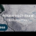
Ice is without doubt one of the first casualties of climate change, but the effects of our warming world are not only limited to ice melting on Earth’s surface. Ground that has been frozen for thousands of years, called permafrost, is thawing – adding to the climate crisis and causing serious issues for local communities.
Scientists estimate that the world’s permafrost holds almost double the amount of carbon that is currently in the atmosphere. When permafrost warms and thaws, it releases methane and carbon dioxide, adding these greenhouse gases to the atmosphere and making global warming even worse.
While permafrost cannot be directly observed from space, a lot of different types of satellite data, along with ground measurements and modelling, allow scientists to paint a picture of permafrost ground conditions.
Credits: ESA – European Space Agency
★ Subscribe: http://bit.ly/ESAsubscribe and click twice on the bell button to receive our notifications.
We are Europe’s gateway to space. Our mission is to shape the development of Europe’s space capability and ensure that investment in space continues to deliver benefits to the citizens of Europe and the world. Check out https://www.esa.int/ to get up to speed on everything space related.
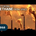
Methane is the second most important greenhouse gas contributor to climate change after carbon dioxide. Curbing methane emissions could deliver immediate and long-lasting benefits for the climate, seeing as the gas only lingers in the atmosphere for a relatively short time. Satellites have a really important role to play in reducing greenhouse gas emissions. The Tropomi instrument onboard the Copernicus Sentinel-5P satellite is the only instrument that maps global methane concentrations every single day. This lets scientists detect hotspots for large methane sources around the world – allowing us to address the consequences of methane emissions on our climate and environment.
Credits: ESA – European Space Agency
★ Subscribe: http://bit.ly/ESAsubscribe and click twice on the bell button to receive our notifications.
We are Europe’s gateway to space. Our mission is to shape the development of Europe’s space capability and ensure that investment in space continues to deliver benefits to the citizens of Europe and the world. Check out https://www.esa.int/ to get up to speed on everything space related.
According to the @worldmetorg, July 2023 is likely to have been the hottest month on record. While much of Europe, North America and Asia suffered the immediate consequences of these brutal temperatures, extreme events are also hitting hard far away in the icy reaches of Antarctica. In a paper published today, scientists highlight Antarctica’s vulnerability to extremes and the role that satellites play in monitoring this remote region.
The summer fire season is well under way in Europe – countries all around the Mediterranean are experiencing record temperatures coupled with huge wildfires that have led to mass evacuations. In this enthralling new ESA documentary, explore how people on the frontline are using space to better monitor and fight the flames.
Follow the incredible stories of the firefighters who dealt with unprecedented fires in Gironde, France, and the forest officers using satellite data to plan for the forests’ recovery. Journey into the heart of Earth’s elemental might and discover how space is changing the game for monitoring volcanic eruptions too – including one of the world’s most studied volcano, Mount Etna.
FIRE is the first episode of ESA’s new series centred around the elements and showcases how Earth observation has become crucial to those fighting climate change on the ground.
Chapters: 00:00 – 11:23 Fighting wildfires in Gironde 11:23 – 24:13 The fire from volcanoes – walking up Mount Etna 24:13 – 31:45 Regenerating the burnt forests and getting ready for the next fire season in Gironde 31:45 – 33:01 Outro
Credits: ESA – European Space Agency
★ Subscribe: http://bit.ly/ESAsubscribe and click twice on the bell button to receive our notifications.
We are Europe’s gateway to space. Our mission is to shape the development of Europe’s space capability and ensure that investment in space continues to deliver benefits to the citizens of Europe and the world. Check out https://www.esa.int/ to get up to speed on everything space related.
As global temperatures increase, the melting of the massive ice sheets that blanket Antarctica and Greenland has accelerated, making a significant contribution to sea-level rise. In total, Earth is losing around a trillion tonnes of ice each year – which is not being replenished.
Andrew Shepherd of the University of Leeds is a leading climate scientist working with ESA and @NASA. Join Andrew as he discusses how long-term satellite observations from ESA’s Climate Change Initiative are key in monitoring changes in ice sheets over decades.
We are Europe’s gateway to space. Our mission is to shape the development of Europe’s space capability and ensure that investment in space continues to deliver benefits to the citizens of Europe and the world. Check out https://www.esa.int/ to get up to speed on everything space related.
Thanks to ESA’s CryoSat satellite and a breakthrough way of using its data, scientists have discovered that glaciers worldwide have shrunk by a total of 2% in just 10 years, and it’s because of higher air temperatures.
We are Europe’s gateway to space. Our mission is to shape the development of Europe’s space capability and ensure that investment in space continues to deliver benefits to the citizens of Europe and the world. Check out https://www.esa.int/ to get up to speed on everything space related.
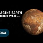
Imagine the world without water: as cold and lifeless as the planet Mars. Earth is unique in our solar system in being able to sustain liquid water on its surface. Water is essential for life and for Earth’s climate, helping transport heat around the planet, but it is difficult to track through the whole water cycle. The global view offered by satellites helps. ESA’s Climate Change Initiative is looking at a range of climate variables linked to the water cycle.
We are Europe’s gateway to space. Our mission is to shape the development of Europe’s space capability and ensure that investment in space continues to deliver benefits to the citizens of Europe and the world. Check out https://www.esa.int/ to get up to speed on everything space related.
In the 1980s, scientists discovered a gaping hole in Earth’s ozone layer, caused by humanmade chemicals. But what is the ozone hole? Join us to find out!
We are Europe’s gateway to space. Our mission is to shape the development of Europe’s space capability and ensure that investment in space continues to deliver benefits to the citizens of Europe and the world. Check out https://www.esa.int/ to get up to speed on everything space related.
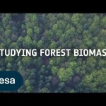
In this video, forestry expert Maurizio Santoro, senior researcher at Gamma Remote Sensing and one of the leaders of ESA projects related to the Climate Change Initiative (CCI), explains how the use of various data, whether in synergy or in comparison, can bring a great contribution/benefit to the field of mapping biomass and measuring this Essential Climate Variable.
★ Subscribe: http://bit.ly/ESAsubscribe and click twice on the bell button to receive our notifications.
We are Europe’s gateway to space. Our mission is to shape the development of Europe’s space capability and ensure that investment in space continues to deliver benefits to the citizens of Europe and the world. Check out https://www.esa.int/ to get up to speed on everything space related.
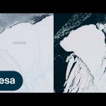
An iceberg around the size of Greater London broke off Antarctica’s Brunt Ice Shelf due to a natural process called ‘calving’. The iceberg, measuring 1550 sq km, detached from the 150 m-thick ice shelf a decade after scientists first spotted massive cracks in the shelf.
We are Europe’s gateway to space. Our mission is to shape the development of Europe’s space capability and ensure that investment in space continues to deliver benefits to the citizens of Europe and the world. Check out https://www.esa.int/ to get up to speed on everything space related.
In this week’s edition of the Earth from Space programme, we take a look at the remarkable moraine patterns of Malaspina Glacier – the largest piedmont glacier in the world – through the eyes of Copernicus Sentinel-2.
We are Europe’s gateway to space. Our mission is to shape the development of Europe’s space capability and ensure that investment in space continues to deliver benefits to the citizens of Europe and the world. Check out https://www.esa.int/ to get up to speed on everything space related.
ESA’s Council at Ministerial level taking place on 22-23 November 2022. It is a crucial milestone as Europe sets out its ambitions and plans for space activities in the coming years and decades.
We want to strengthen Europe’s space sector and ensure we continue to serve European citizens by, for example: Tick preparing new groundbreaking missions to make new scientific discoveries, tick observing the Earth to make sure we collect enough data to mitigate climate change, Tick launching new nav satellites to improve GPS signals across Europe Tick and supporting entrepreneurs and space related businesses.
Stay tuned and find out more about what we are putting on the table at CM22.
★ Subscribe: http://bit.ly/ESAsubscribe and click twice on the bell button to receive our notifications.
We are Europe’s gateway to space. Our mission is to shape the development of Europe’s space capability and ensure that investment in space continues to deliver benefits to the citizens of Europe and the world. Check out https://www.esa.int/ to get up to speed on everything space related.
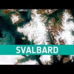
This week’s edition of the Earth from Space programme features a rare, cloud-free Copernicus Sentinel-2 acquisition over the Norwegian archipelago of Svalbard.
We are Europe’s gateway to space. Our mission is to shape the development of Europe’s space capability and ensure that investment in space continues to deliver benefits to the citizens of Europe and the world. Check out https://www.esa.int/ to get up to speed on everything space related.
This week’s edition of the Earth from Space programme features a Copernicus Sentinel-1 radar image of the Mississippi River, one of the longest rivers in North America.
We are Europe’s gateway to space. Our mission is to shape the development of Europe’s space capability and ensure that investment in space continues to deliver benefits to the citizens of Europe and the world. Check out https://www.esa.int/ to get up to speed on everything space related.
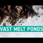
This week’s edition of the Earth from Space programme features a Copernicus Sentinel-2 image of melt ponds in the province of Avannaata in West Greenland.
We are Europe’s gateway to space. Our mission is to shape the development of Europe’s space capability and ensure that investment in space continues to deliver benefits to the citizens of Europe and the world. Check out https://www.esa.int/ to get up to speed on everything space related.
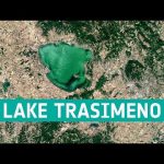
In this week’s edition of the Earth from Space programme, the Copernicus Sentinel-2 mission takes us over Lake Trasimeno, the fourth largest lake in Italy.
We are Europe’s gateway to space. Our mission is to shape the development of Europe’s space capability and ensure that investment in space continues to deliver benefits to the citizens of Europe and the world. Check out https://www.esa.int/ to get up to speed on everything space related.
This week’s edition of the Earth from Space programme features a Copernicus Sentinel-3 image showing the scale of Britain’s heatwave as it baked in extreme temperatures in August.
We are Europe’s gateway to space. Our mission is to shape the development of Europe’s space capability and ensure that investment in space continues to deliver benefits to the citizens of Europe and the world. Check out https://www.esa.int/ to get up to speed on everything space related.
The series of heatwaves we are currently experiencing in western Europe is a clear sign of human-induced global warming. ESA’s Clement Albergel explains how we monitor these events using satellites such as the Copernicus Sentinel-3 mission and puts them in the context of the long-term climate data record generated via ESA’s Climate Change Initiative.
Credits: ESA
★ Subscribe: http://bit.ly/ESAsubscribe and click twice on the bell button to receive our notifications.
We are Europe’s gateway to space. Our mission is to shape the development of Europe’s space capability and ensure that investment in space continues to deliver benefits to the citizens of Europe and the world. Check out https://www.esa.int/ to get up to speed on everything space related.
Satellites observe the Earth using a range of wavelengths on the electromagnetic spectrum. Different wavelengths allow us to probe different aspects of Earth’s land, atmosphere and ocean. By sampling the electromagnetic spectrum at multiple wavelengths, we can build a more complete picture of Earth’s complex climate system.
We are Europe’s gateway to space. Our mission is to shape the development of Europe’s space capability and ensure that investment in space continues to deliver benefits to the citizens of Europe and the world. Check out https://www.esa.int/ to get up to speed on everything space related.
Glaciers across the globe have lost over nine trillion tonnes of ice in half a century. How will glaciers look over the coming decades? “It all depends on what humans are doing now in terms of greenhouse gas emissions:” this is the message one scientist delivered during an ESA-led expedition to the Gorner Glacier in Switzerland – one of the biggest ice masses in the Alps.
As world leaders gather for the 26th @United Nations Climate Change Conference of Parties, watch the exclusive premiere of the documentary that follows ESA astronaut Luca Parmitano, along with a team of glaciologists and climate experts, on their journey across the Alps to learn how rising global temperatures are taking their toll on glaciers.
The documentary features breathtaking scenery of the Gorner Glacier as well as interviews with climate specialists as they explain how we can monitor glaciers using both satellite data and in situ measurements.
We are Europe’s gateway to space. Our mission is to shape the development of Europe’s space capability and ensure that investment in space continues to deliver benefits to the citizens of Europe and the world. Check out https://www.esa.int/ to get up to speed on everything space related.
Satellites play a vital role in monitoring the rapid changes taking place in the Arctic. Tracking ice lost from the world’s glaciers, ice sheets and frozen land shows that Earth is losing ice at an accelerating rate. Currently more than a trillion tonnes of ice is lost each year. The sooner Earth’s temperature is stabilised, the more manageable the impacts of ice loss will be.
Credit: ESA/Planetary Visions
★ Subscribe: http://bit.ly/ESAsubscribe and click twice on the bell button to receive our notifications.
We are Europe’s gateway to space. Our mission is to shape the development of Europe’s space capability and ensure that investment in space continues to deliver benefits to the citizens of Europe and the world. Check out https://www.esa.int/ to get up to speed on everything space related.
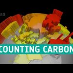
The Paris Agreement adopted a target for global warming not to exceed 1.5°C. This sets a limit on the additional carbon we can add to the atmosphere – the carbon budget. Only 18% of the carbon budget is now left. That is about 10 years at current emission rates.
Each country reports its annual greenhouse gas emissions to the United Nations. Scientists then set these emissions against estimates of the carbon absorbed by Earth’s natural carbon sinks. This is known as the bottom-up approach to calculating the carbon budget.
Another way to track carbon sources and sinks is to measure the amounts of greenhouse gases in the atmosphere from space – the top-down approach. As well as tracking atmospheric carbon, ESA’s Climate Change Initiative is using satellite observations to track other carbon stocks on land and sea.
How we use the land accounts for about a quarter of our greenhouse gas emissions. Forests are the largest store of carbon on the land. Fire acts as a conduit for carbon to pass from the land to the atmosphere. And phytoplankton in the ocean is an important carbon sink.
ESA’s RECCAP-2 project is using this information to reconcile the differences between the bottom-up and top-down approaches. Observations are combined with atmospheric and biophysical computer models to deduce carbon fluxes at the surface. This will improve the precision of each greenhouse gas budget and help separate natural fluxes from agricultural and fossil fuel emissions. This work will help us gauge whether we can stay within the 1.5°C carbon budget, or if more warming is in store.
Credits: ESA/Planetary Visions
★ Subscribe: http://bit.ly/ESAsubscribe and click twice on the bell button to receive our notifications.
We are Europe’s gateway to space. Our mission is to shape the development of Europe’s space capability and ensure that investment in space continues to deliver benefits to the citizens of Europe and the world. Check out https://www.esa.int/ to get up to speed on everything space related.
The giant A-68A iceberg could strike land this month – wreaking havoc near the waters of the South Georgia Island.
Since its ‘birth’ in 2017, the iceberg has travelled thousands of kilometres from the Larsen C ice shelf, in Antarctica, and now lies around 120 km from South Georgia. If it remains on its current path, the iceberg could ground in the shallow waters offshore – threatening wildlife, including penguins and seals.
Satellite missions are being used to track the berg on its journey over the past three years. The Copernicus Sentinel-1 radar mission, with its ability to see through clouds and the dark, has been instrumental in mapping the polar regions in winter.
Credits: ESA
★ Subscribe: http://bit.ly/ESAsubscribe and click twice on the bell button to receive our notifications.
We are Europe’s gateway to space. Our mission is to shape the development of Europe’s space capability and ensure that investment in space continues to deliver benefits to the citizens of Europe and the world. Check out https://www.esa.int/ to get up to speed on everything space related.
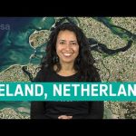
The Copernicus Sentinel-2 mission takes us over Zeeland – the westernmost province in the Netherlands, in this week’s edition of the Earth from Space programme.
We are Europe’s gateway to space. Our mission is to shape the development of Europe’s space capability and ensure that investment in space continues to deliver benefits to the citizens of Europe and the world. Check out http://www.esa.int/ESA to get up to speed on everything space related.
We are Europe’s gateway to space. Our mission is to shape the development of Europe’s space capability and ensure that investment in space continues to deliver benefits to the citizens of Europe and the world. Check out http://www.esa.int/ESA to get up to speed on everything space related.
The Arctic is one of the most rapidly changing regions in the world. Diminishing sea ice, thawing permafrost and melting glaciers are all direct effects of rising global temperatures – driven by human-made emissions. Learn more about how satellites flying 800 km above our heads can help us monitor and understand the changes occurring in this remote region.
★ Subscribe: http://bit.ly/ESAsubscribe and click twice on the bell button to receive our notifications.
We are Europe’s gateway to space. Our mission is to shape the development of Europe’s space capability and ensure that investment in space continues to deliver benefits to the citizens of Europe and the world. Check out http://www.esa.int/ESA to get up to speed on everything space related.
The Copernicus Sentinel-2 mission takes us over New York City – the most populous city in the United States, in this week’s edition of the Earth from Space programme.
We are Europe’s gateway to space. Our mission is to shape the development of Europe’s space capability and ensure that investment in space continues to deliver benefits to the citizens of Europe and the world. Check out http://www.esa.int/ESA to get up to speed on everything space related.
The Copernicus Sentinel-2 mission takes us over the Tarawa Atoll in the Republic of Kiribati – a remote Pacific nation threatened by rising seas, in this week’s edition of the Earth from Space programme.
We are Europe’s gateway to space. Our mission is to shape the development of Europe’s space capability and ensure that investment in space continues to deliver benefits to the citizens of Europe and the world. Check out http://www.esa.int/ESA to get up to speed on everything space related.