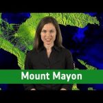
Explore the Philippines’ Mount Mayon, one of the world’s most active volcanoes, in this episode of Earth from Space, presented by Kelsea Brennan-Wessels from the ESA Web TV virtual studios.
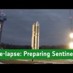
See in this time-lapse how the Sentinel-3B satellite was prepared for its liftoff on 25 April 2018 from Plesetsk in Russia.
Sentinel-3B joined its twin, Sentinel-3A, in orbit. The pairing of identical satellites provides the best coverage and data delivery for Europe’s Copernicus programme – the largest environmental monitoring programme in the world. The satellites carry the same suite of cutting-edge instruments to measure oceans, land, ice and atmosphere.
Credits: Directed by Stephane Corvaja, ESA; Edited by Manuel Pedoussaut, Zetapress; Music by Hubrid-Rockot
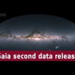
Astronomy is undergoing a revolution with the release of precision data on 1.7 billion stars in our galaxy from the Gaia space telescope. We head to the historic Observatory of Paris and ESA’s ESTEC base in the Netherlands to find out more.
It’s fair to say that science has been waiting for centuries, or even millennia for such a detailed survey of the Milky Way, and right now star-gazers are swamped with fresh, high-quality data that they can use to answer every question about the galaxy they ever wanted to ask.
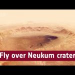
This movie, based on images taken by ESA’s Mars Express, showcases the 102 km wide Neukum Crater in the southern hemisphere of Mars.
The crater is named for the German physicist and planetary scientist, Gerhard Neukum, one of the founders of ESA’s Mars Express mission who inspired and led the development of the high-resolution stereo camera on Mars Express.
This complex impact crater has a diverse geologic history, as indicated by various features on the crater rim and floor. Particularly striking are the dark dune fields, likely made up of volcanic material blown in and shaped by strong winds.
The crater’s shallow interior has been infilled by sediments over its history. It is also marked with two irregular depressions that may be a sign of a weaker material that has since eroded away, leaving behind some islands of more resistant material.
Over time the crater rim has undergone varying degrees of collapse, with landslides and slumped material visible in the crater walls. Many smaller craters have also overprinted the rim and pockmarked the interior since Neukum Crater was formed, highlighting its long history.
Neukum Crater is situated in Noachis Terra, one of the oldest known regions on Mars, dating back to at least 3.9 billion years.
Credits: Animation: ESA/DLR/FU Berlin, CC BY-SA 3.0 IGO; Music: Coldnoise, CC BY-SA 4.0 and Adrian Neesemann
‘Horizons’ is the name of ESA astronaut Alexander Gerst’s second mission to the International Space Station.
The mission name evokes exploring our Universe, looking far beyond our planet and broadening our knowledge. Alexander would also like to make people realise that there is always a chance to go beyond their personal horizons.
Alexander will be launched on 6 June with US astronaut Serena Auñón-Chancellor and Russian cosmonaut Sergei Prokopyev from the Baikonur cosmodrome, Kazakhstan in the Soyuz MS-09 spacecraft.
Alexander will take over command of the International Space Station for the second half of his mission. Alexander Gerst is the 11th German citizen to fly into space.
The astronaut is now in the last stages of training for his challenging spaceflight. The science programme is packed with European research: more than 50 experiments will deliver benefits to people back on Earth and prepare for future space exploration.
Credits: ESA
Spacecraft in orbit and on Mars’s surface have made many exciting discoveries, transforming our understanding of the planet and unveiling clues to the formation of our Solar System, as well as helping us understand our home planet. The next step is to bring samples to Earth for detailed analysis in sophisticated laboratories where results can be verified independently and samples can be reanalysed as laboratory techniques continue to improve.
Bringing Mars to Earth is no simple undertaking—it would require at least three missions from Earth and one never-been-done-before rocket launch from Mars.
A first mission, NASA’s 2020 Mars Rover, is set to collect surface samples in pen-sized canisters as it explores the Red Planet. Up to 31 canisters will be filled and readied for a later pickup – geocaching gone interplanetary.
In the same period, ESA’s ExoMars rover, which is also set to land on Mars in 2021, will be drilling up to two meters below the surface to search for evidence of life.
A second mission with a small fetch rover would land nearby and retrieve the samples in a Martian search-and-rescue operation. This rover would bring the samples back to its lander and place them in a Mars Ascent Vehicle – a small rocket to launch the football-sized container into Mars orbit.
A third launch from Earth would provide a spacecraft sent to orbit Mars and rendezvous with the sample containers. Once the samples are safely collected and loaded into an Earth entry vehicle, the spacecraft would return to Earth, release the vehicle to land in the United States, where the samples will be retrieved and placed in quarantine for detailed analysis by a team of international scientists.
Earth from Space is presented by Kelsea Brennan-Wessels from the ESA Web TV virtual studios. A mosaic of cloud-free images from the Copernicus Sentinel-3A satellite spanning Europe is featured in this edition.
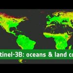
The Copernicus Sentinel-3B satellite spent six weeks at the Plesetsk cosmodrome in Russia being carefully prepared for liftoff. After being shipped from France to the launch site, the satellite was tested, joined to the rocket launch adapter, sealed from view in the fairing and taken by train to the launch pad. Sentinel-3B lifted off on 25 April 2018 at 17:57 GMT (19:57 CEST).
It joins its twin, Sentinel-3A, in orbit. The pairing of identical satellites provides the best coverage and data delivery for Europe’s Copernicus programme – the largest environmental monitoring programme in the world. The satellites carry the same suite of cutting-edge instruments to measure oceans, land, ice and atmosphere. While these data are fed primarily into the Copernicus Marine Environment Monitoring Service, all the Copernicus services benefit to produce knowledge and information products in near-real time for a wide range of applications. The Sentinel-3 mission is essential for applications for ocean and coastal monitoring, numerical weather and ocean prediction, sea-level change and sea-surface topography monitoring, ocean primary production estimation and land-cover change mapping.
The second data release of ESA’s Gaia mission has produced an extraordinary catalogue of over one and a half billion stars in our galaxy. Based on observations between July 2014 to May 2016, it includes the most accurate information yet on the positions, brightness, distance, motion, colour and temperature of stars in the Milky Way as well as information on asteroids and quasars.
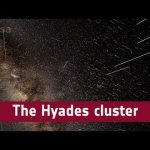
Animated 3D view of the sky as observed by ESA’s Gaia satellite using information from the mission’s second data release.
The bright band in the left half of the image is the Milky Way, where most of the stars in our Galaxy reside. The animation starts with the Orion constellation at the centre; we then move towards the neighbouring Taurus constellation and to the Hyades star cluster, which is part of this constellation. Hyades is the closest open cluster to the Solar System, some 150 light-years away.
The animation first shows the 3D structure of the cluster, based on accurate position and distance information from Gaia. Then an animated view of the future motions of stars is shown – both in Hyades and beyond. This is based on Gaia’s measurements of the velocity of stars across the sky, also known as proper motion.
Credit: ESA/Gaia/DPAC, CC BY SA 3.0 IGO
Acknowledgement: Gaia Data Processing and Analysis Consortium (DPAC); Gaia Sky; S. Jordan / T. Sagristà, Astronomisches Rechen-Institut, Zentrum für Astronomie der Universität Heidelberg, Germany
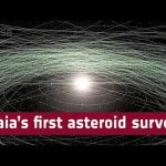
Animated view of 14 099 asteroids in our Solar System, as viewed by ESA’s Gaia satellite using information from the mission’s second data release. The orbits of the 200 brightest asteroids are also shown, as determined using Gaia data.
In future data releases, Gaia will also provide asteroid spectra and enable a complete characterisation of the asteroid belt. The combination of dynamical and physical information that is being collected by Gaia provides an unprecedented opportunity to improve our understanding of the origin and the evolution of the Solar System.
Credit: ESA/Gaia/DPAC, CC BY SA 3.0 IGO
Acknowledgement: Gaia Data Processing and Analysis Consortium (DPAC); Orbits: Gaia Coordinating Unit 4; P. Tanga, Observatoire de la Côte d’Azur, France; F. Spoto, IMCCE, Observatoire de Paris, France; Animation: Gaia Sky; S. Jordan / T. Sagristà, Astronomisches Rechen-Institut, Zentrum für Astronomie der Universität Heidelberg, Germany
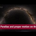
A 360° animated view of the entire sky on 25 April 2018.
After a few seconds, the stars start moving in the sky according to parallax, an apparent shift caused by Earth’s yearly motion around the Sun. Then, constellation outlines appear as visual aids. Finally, stars start moving according to their true motion through space, which is visible on the sky as proper motion. Parallaxes have been exaggerated by 100 000 and proper motions have been speeded up by one trillion (10^12) to make them visible in this animation. This animation is based on data from the second data release of ESA’s Gaia satellite, which has measured the positions, parallaxes and motions of more than one billion stars across the sky to unprecedented accuracy.
ESA/Gaia/DPAC, CC BY SA 3.0 IGO
Acknowledgement: Gaia Data Processing and Analysis Consortium (DPAC); Gaia Sky; S. Jordan / T. Sagristà, Astronomisches Rechen-Institut, Zentrum für Astronomie der Universität Heidelberg, Germany
Meet our new space explorers, the spacecraft of the BepiColombo mission, as they begin their adventure to planet Mercury. But first, they have to navigate through Amsterdam Schiphol airport to reach Europe’s spaceport in Kourou, French Guiana.
The spacecraft really do depart from Schiphol; along with essential ground-support equipment they are scheduled to fly in a series of Antonov aircraft during the last week of April and first week of May. Upon arrival at Kourou, an intensive six-months of preparations will prepare the mission for launch. The launch window opens 5 October until 29 November 2018.
Find out more about the BepiColombo mission on esa.int/bepicolombo
On 25 April 2018, ESA’s Gaia mission will publish its much awaited second data release, including high-precision measurements of nearly 1.7 billion stars in our Galaxy.
Scientists who have been working on creating and validating the data contained in the catalogue tell us why they are waiting for this extraordinary release.
Featured in the video: Antonella Vallenari (INAF, Astronomical Observatory of Padua), Anthony Brown (Leiden University), Timo Prusti (European Space Agency), Annie Robin (Institut UTINAM, OSU THETA Franche-Comté-Bourgogne), Laurent Eyer (University of Geneva) and Federica Spoto (IMCCE, Observatory of Paris).
A media briefing on the second Gaia data release will be held at the ILA Berlin Air and Space Show in Germany on 25 April 11:00-12:15 CEST. Watch the webstream at www.esa.int/live
We meet a surfing scientist and toxic algae hunters to see how Sentinel-3 satellite data is used to study the coastline of the English Channel in this month’s episode of Space.
Bob Brewin is pioneering a new technique in satellite oceanography – by going surfing. The Plymouth Marine Laboratory scientist uses his board to take sea surface temperature measurements, and then use them to better interpret data from European satellite Sentinel-3.
In this special edition of Earth from Space, senior project scientist at Gamma Remote Sensing, Dr Maurizio Santoro, joins the show to discuss how his team estimates forest biomass from space.
When people think about the big players of the space industry, they don’t tend to think about Europe. But believe it or not the European Space Agency or ESA has the second highest budget out of any space agency. So what are they doing with all that money?
Our alien friend Paxi, ESA Education’s mascot, went to visit American astronaut Scott Tingle on board the International Space Station. Tingle tells Paxi about how astronauts sleep in weightlessness, an important aspect of living on the ISS.
Having a stressful day? We got you covered! Sit back, turn the volume up and enjoy a relaxing moment brought to you by ESA and Lufthansa exploring the countries which make up the European Space Agency with images taken by the Copernicus Sentinel-1A, Sentinel-2A and Sentinel-3A, Proba-V and Envisat satellites.
Don’t forget to favourite this video. You will always have a space to relax with us.
Every week, on average, a substantial, inert satellite drops into our atmosphere and burns up. Monitoring these reentries and warning European civil authorities has become routine work for ESA’s space debris experts.
Each year, about 100 tonnes of defunct satellites, uncontrolled spacecraft, spent upper stages and discarded items like instrument covers are dragged down by Earth’s upper atmosphere, ending their lives in flaming arcs across the sky.
Some of these objects are big and chunky, and pieces of them survive the fiery reentry to reach the surface. Our planet, however, is a big place, mostly covered by water, and much of what falls down is never seen by anyone, sinking to the bottom of some ocean, or landing far from human habitation.
While still in orbit, these and many other objects are tracked by a US military radar network, which shares the data with ESA, since Europe has no such capability of its own.It’s the task of ESA’s Space Debris team to look at these data and issue updates to ESA Member States and partner civil authorities around the globe.
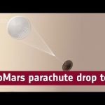
The video features footage taken of the parachute deployment as seen from the ground, as well as from onboard GoPros fixed to the drop test vehicle and looking up at the parachute. The test focused on the deployment and inflation of the second main stage 35m-wide parachute, which will be the largest to fly on Mars.
Discussing the test are Stephane Langlois, ESA ExoMars engineer, and John Underwood, principal engineer at Vorticity.
The test was carried out by Vorticity Ltd under supervision of Thales Alenia Space France, Thales Alenia Space Italy and ESA, in Kiruna, Sweden, on 2 March 2018.
Having a stressful day? We got you covered!Sit back, turn the volume up and enjoy a relaxing moment brought to you by ESA and Lufthansa getting lost in the beauty of our planet with images captured by Envisat, JAXA ALOS, KARI Kompsat-2, GeoEye Ikonos-2 and NASA Landsat-5 and Landsat-7 satellites.
Don’t forget to favourite this video. You will always have a space to relax with us.
Earth from Space is presented by Kelsea Brennan-Wessels from the ESA Web TV virtual studios. In this edition, Sentinel-2A satellite takes us over Japan’s capital, the world’s largest megacity.
Having a stressful day? We got you covered! Sit back, turn the volume up and enjoy a relaxing moment brought to you by ESA and Lufthansa exploring the coldest parts of our planet with a collection of ice images captured by the Envisat satellite.
Don’t forget to favourite this video. You will always have a space to relax with us.
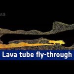
The “Cueva de los Verdes” lava tube in Lanzarote, Spain, is one of the world’s largest volcanic cave complexes with a total length of about 8 km.
Geology experts from ESA’s Pangaea-X campaign mapped most of the lava tube system as part of a project supported by local authorities Cabildo of Lanzarote and the University of Padova, Italy. The data was acquired in November 2017 by Leica Geosystems.
The map comes alive in great detail in 3D, helping institutions to protect the subterranean environment. The map also provides scientific data to study the origins of the tube and its peculiar formations.
Pangaea-X is a test campaign that brings together geology, high-tech survey equipment and space exploration. Learn more about the science and technology behind this campaign visiting http://blogs.esa.int/pangaea
Earth from Space is presented by Kelsea Brennan-Wessels from the ESA Web TV virtual studios. In this edition, Sentinel-3A treats us to a view stretching from Sardinia to Romania.
Following its launch in February 2016 and subsequent commissioning phase, the Copernicus Sentinel-3A satellite has been systematically measuring our oceans, land, ice and atmosphere. The information feeds a range of practical applications and is used for monitoring and understanding large-scale global dynamics. Sentinel-3A will soon be joined in orbit by its identical twin, Sentinel-3B. Both satellites carry a suite of cutting-edge instruments to supply a new generation of data products, which are particularly useful for marine applications. For example, they monitor ocean-surface temperatures for ocean and weather forecasting services, aquatic biological productivity, ocean pollution and sea-level change. The mission also delivers unique and timely information about changing land cover, vegetation, urban heat islands, and for tracking wildfires. With the two satellites in orbit, global coverage and data delivery will be optimised.
The sixth Space App Camp was held at ESA’s establishment in Frascati, Italy, in September 2017. The camp offers access to the latest space data – particularly from the European Copernicus programme – to app developers, who work to make the information accessible to a broad audience. Twenty-four developers from 14 countries attended the 2017 camp. In this short video, participants talk about why they attended and what they hoped to achieve.
Located in Frascati, Italy, ESRIN – known as the ESA Centre for Earth Observation – is one of the five ESA specialised centres situated in Europe. The mission and payload operations of ESA’s Earth observation satellites are managed here and ESRIN is the primary source for the acquisition, distribution and exploitation of data from these and other non-ESA satellites.Within ESRIN, a key role in Europe’s space effort has been undertaken with the development of the new small launcher, Vega, which took its maiden voyage in February 2012. ESRIN designs and develops all ESA-wide software for corporate applications and is responsible for developing security measures for classified space programmes. The European Centre for Space Records (ECSR) is also based at ESRIN. The ECSR appraises and preserves the valuable technical records of completed ESA projects together with their management archives to safeguard this valuable knowledge for generations to come.Finally, ESRIN is home to ESA’s Near-Earth Object Coordination Centre. The centre serves as the central access point to a network of European near-Earth object data sources and information providers being established under ESA’s Space Situational Awareness (SSA) Programme.For more information, visit the ESRIN site.
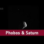
These observations of Phobos and Saturn were taken by the Super Resolution Channel of the High Resolution Stereo Camera on Mars Express. The video comprises 30 separate images acquired during Mars Express orbit 16 346 on 26 November 2016. The slight up and down movement of Saturn and Phobos in these images is caused by the oscillation of the spacecraft’s orientation after completing the turn towards the moon. Phobos can be seen in the foreground, partially illuminated, with Saturn visible as a small ringed dot in the distance. For more information go tohttp://www.esa.int/Our_Activities/Space_Science/Mars_Express/Mars_Express_views_moons_set_against_Saturn_s_rings
From ESA astronaut Luca Parmitano’s hometown in Catania, Italy, Luca talks about the science he ran on the International Space Station.
The European laboratory Columbus was launched in 2008 and offers scientists a permanent place in space to conduct research that is out of this world.
Luca’s first spaceflight was in 2013 with Russian cosmonaut Fyodor Yurchikhin and NASA astronaut Karen Nyberg. He conducted over 20 experiments during the Volare mission as flight engineer for Expeditions 36 and 37 and he was the first of ESA’s new generation of astronauts to fly into space.
Luca talks about space research, being a human guinea pig, dieting to avoid bone disease osteoporosis, human physiology, using ultrasound remotely to diagnose back problems, measuring eye pressure and how his body and mind reacted to living in weightlessness.
Luca is set for a second mission to the International Space Station in 2019.
The Rio Tinto river snakes through the Spanish countryside for 100 kilometres, a dark, blood-red stain of acid water and rusty-looking rocks that scientists love to study. Both ESA and NASA experts regularly spend weeks in the Rio Tinto, examining the life underground, and using it as a test bed to look for life on Mars.
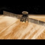
Since arriving at Mars in October 2016, the ExoMars Trace Gas Orbiter has been aerobraking its way into a close orbit of the Red Planet by using the top of the atmosphere to create drag and slow down. It is almost in the right orbit to begin observations – only a few hundred kilometres to go! With aerobraking complete, additional manoeuvres will bring the craft into a near-circular two-hour orbit, about 400 km above the planet, by the end of April. The mission’s main goal is to take a detailed inventory of the atmosphere, sniffing out gases like methane, which may be an indicator of active geological or biological activity. The camera will help to identify surface features that may be related to gas emissions. The spacecraft will also look for water-ice hidden below the surface, which could influence the choice of landing sites for future exploration. It will also relay large volumes of science data from NASA’s rovers on the surface back to Earth and from the ESA–Roscosmos ExoMars rover, which is planned for launch in 2020.
ESA’s Earth Explorer Aeolus satellite will be launched later this year to measure the world’s winds from space. The satellite carries one of the most sophisticated instruments ever to be put into orbit: Aladin, which includes two powerful lasers, a large telescope and very sensitive receivers. The laser generates ultraviolet light that is beamed down into the atmosphere to profile the world’s winds – a completely new approach to measuring the wind from space. These vertical slices through the atmosphere, along with information it gathers on aerosols and clouds, will improve our understanding of atmospheric dynamics and contribute to climate research. As well as advancing science, Aeolus will play an important role in improving weather forecasts. The mission will also complement information about the atmosphere being provided by the Copernicus Sentinel missions.
The European Space Agency (ESA) is part of an international effort to monitor and – ultimately – tackle space debris. This junk – accumulated in orbit since the dawn of the space age sixty years ago – poses an increasing risk to operational spacecraft.
ESA is developing missions to tackle the problem to help prevent a serious collision in space. The Agency is also monitoring possible dangers caused by fragments of redundant spacecraft falling to Earth, such as China’s space station Tiangong-1 – due to enter the atmosphere in the coming months.